
| Birth | : | 17 May 1918 Cardston, Claresholm Census Division, Alberta, Canada |
| Death | : | 14 Oct 2011 Vulcan, Strathmore Census Division, Alberta, Canada |
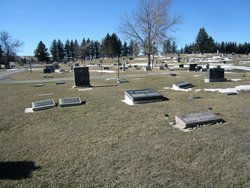
| Burial | : | Carmangay Cemetery, Carmangay, Strathmore Census Division, Canada |
| Coordinate | : | 50.1214300, -113.1434300 |
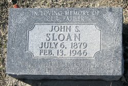
| Description | : | VULCAN FUNERAL HOME - OBIT EXCERPTS MITH, EMMA May 17, 1918 – October 14, 2011 Our mother Emma Sloan Smith, passed away at the Vulcan Community Health Centre October 14,2011. She was also predeceased by her baby boy who lived six hours, two grandsons, Kenneth in 1978 and Reid Karl in 1996, her husband Fay D. Smith in 1981 and Raymond Fath to whom she was married 1996-2002. Mother was a survivor of the 1918 flu epidemic and at the age of 6 months was left with chronic bronchiectasis. In spite of her... Read More |
frequently asked questions (FAQ):
-
Where is Emma Margaret Sloan Smith's memorial?
Emma Margaret Sloan Smith's memorial is located at: Carmangay Cemetery, Carmangay, Strathmore Census Division, Canada.
-
When did Emma Margaret Sloan Smith death?
Emma Margaret Sloan Smith death on 14 Oct 2011 in Vulcan, Strathmore Census Division, Alberta, Canada
-
Where are the coordinates of the Emma Margaret Sloan Smith's memorial?
Latitude: 50.1214300
Longitude: -113.1434300
Family Members:
Parent

Spouse

Siblings

Children
Flowers:


Nearby Cemetories:
1. Carmangay Cemetery
Carmangay, Strathmore Census Division, Canada
Coordinate: 50.1214300, -113.1434300
2. Isol Russell Grave
Champion, Strathmore Census Division, Canada
Coordinate: 50.1792300, -113.2102100
3. Alston Cemetery
Vulcan, Strathmore Census Division, Canada
Coordinate: 50.1652820, -113.2450470
4. Carmangay Hutterite Cemetery
Carmangay, Strathmore Census Division, Canada
Coordinate: 50.0841743, -113.0067984
5. Elinor Cemetery
Barons, Lethbridge Census Division, Canada
Coordinate: 50.0271520, -113.2340240
6. Champion Cemetery
Champion, Strathmore Census Division, Canada
Coordinate: 50.2329200, -113.1441800
7. Fath Hill Catholic Cemetery
Champion, Strathmore Census Division, Canada
Coordinate: 50.2153400, -113.2544200
8. Barons Cemetery
Barons, Lethbridge Census Division, Canada
Coordinate: 49.9756500, -113.0993100
9. Cleverville Cemetery
Champion, Strathmore Census Division, Canada
Coordinate: 50.2736100, -113.1661700
10. Keho Lake Hutterite Cemetery
Barons, Lethbridge Census Division, Canada
Coordinate: 49.9891594, -113.0160634
11. Shadow Ranch Hutterite Cemetery
Champion, Strathmore Census Division, Canada
Coordinate: 50.1820466, -112.8929664
12. Little Bow Hutterite Cemetery
Stavely, Claresholm Census Division, Canada
Coordinate: 50.2142141, -113.3694417
13. Bowville Cemetery
Carmangay, Strathmore Census Division, Canada
Coordinate: 50.0847700, -112.8720800
14. White Lake Hutterite Cemetery
Nobleford, Lethbridge Census Division, Canada
Coordinate: 49.9154153, -113.2084160
15. Albion Ridge Cemetery
Barons, Lethbridge Census Division, Canada
Coordinate: 49.9598350, -112.9169650
16. White Lake Cemetery
Nobleford, Lethbridge Census Division, Canada
Coordinate: 49.9018700, -113.2107750
17. Saint Peter's Lutheran Cemetery
Claresholm, Claresholm Census Division, Canada
Coordinate: 50.0487620, -113.4822460
18. Five Mile Cemetery
Claresholm, Claresholm Census Division, Canada
Coordinate: 50.0188250, -113.4705730
19. Nobleford Monarch Cemetery
Nobleford, Lethbridge Census Division, Canada
Coordinate: 49.8456500, -113.0942100
20. Reid Hill Cemetery
Vulcan, Strathmore Census Division, Canada
Coordinate: 50.3974000, -113.0295500
21. Granum Christian Reformed Church Cemetery
Granum, Claresholm Census Division, Canada
Coordinate: 49.8622100, -113.3436600
22. Vulcan Cemetery
Vulcan, Strathmore Census Division, Canada
Coordinate: 50.4032200, -113.2774100
23. Jumbo Valley Hutterite Cemetery
Granum, Claresholm Census Division, Canada
Coordinate: 49.8452911, -113.3425358
24. Claresholm Cemetery
Claresholm, Claresholm Census Division, Canada
Coordinate: 50.0114784, -113.5946503