
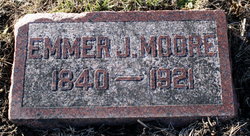
Emmer Jane Walbridge Moore
| Birth | : | 30 Nov 1840 Erie County, Pennsylvania, USA |
| Death | : | 20 Dec 1921 Pawnee City, Pawnee County, Nebraska, USA |
| Burial | : | Pawnee City Cemetery, Pawnee City, Pawnee County, USA |
| Coordinate | : | 40.1109009, -96.1608810 |
| Plot | : | Orig. 34 1/2- 2 |
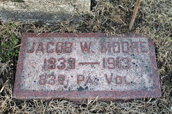
| Description | : | Daughter of John Walbridge & Jane Malory Walbridge. Sister of Florence Helen Walbridge Jordan. Married to Jacob William Moore Dec. 26, 1864. They were the parents of six daughters. (Pawnee Library, book of obits in the Pawnee Republican.) TABLE ROCK ARGUS, Dec.23, 1921. Mrs. Emmer F. Moore, widow of the late Jacob Moore, died at Pawnee City on December 20th, age 81 years and 20 days. The funeral was held from the home of George W. Tracy, at Pawnee City yesterday. Mrs. Moore was mother of Mrs. J. B. Phillips of our city and spent much time with her daughter here since the death of... Read More |
frequently asked questions (FAQ):
-
Where is Emmer Jane Walbridge Moore's memorial?
Emmer Jane Walbridge Moore's memorial is located at: Pawnee City Cemetery, Pawnee City, Pawnee County, USA.
-
When did Emmer Jane Walbridge Moore death?
Emmer Jane Walbridge Moore death on 20 Dec 1921 in Pawnee City, Pawnee County, Nebraska, USA
-
Where are the coordinates of the Emmer Jane Walbridge Moore's memorial?
Latitude: 40.1109009
Longitude: -96.1608810
Family Members:
Spouse
Children

Flowers:


Nearby Cemetories:
1. Pawnee City Cemetery
Pawnee City, Pawnee County, USA
Coordinate: 40.1109009, -96.1608810
2. East Amish Cemetery
Table Rock, Pawnee County, USA
Coordinate: 40.1310000, -96.0854000
3. Evergreen Cemetery
Pawnee County, USA
Coordinate: 40.0485992, -96.1417007
4. Pleasant Valley Cemetery
Pawnee County, USA
Coordinate: 40.0299988, -96.1554794
5. Table Rock Cemetery
Table Rock, Pawnee County, USA
Coordinate: 40.1791400, -96.1037400
6. Prairie Star Pioneer Cemetery
Du Bois, Pawnee County, USA
Coordinate: 40.0293000, -96.1041000
7. Beranek Cemetery
Table Rock, Pawnee County, USA
Coordinate: 40.2042007, -96.1607971
8. Pleasant Ridge Cemetery
Du Bois, Pawnee County, USA
Coordinate: 40.0156000, -96.1494000
9. West Branch Cemetery
Pawnee County, USA
Coordinate: 40.0787940, -96.2797160
10. Saint Anthonys Cemetery
Steinauer, Pawnee County, USA
Coordinate: 40.2075005, -96.2189026
11. Johnson Creek Cemetery
Pawnee City, Pawnee County, USA
Coordinate: 40.0270000, -96.2465000
12. Clear Creek Cemetery
Table Rock, Pawnee County, USA
Coordinate: 40.2193985, -96.1391983
13. Bohemian Cemetery
Table Rock, Pawnee County, USA
Coordinate: 40.1786003, -96.0374985
14. Saint Peters Evangelican Cemetery
Du Bois, Pawnee County, USA
Coordinate: 40.0010000, -96.1095000
15. Dry Branch Pioneer Cemetery
Richardson County, USA
Coordinate: 40.1292000, -96.0100021
16. DuBois Cemetery
Du Bois, Pawnee County, USA
Coordinate: 40.0231018, -96.0488968
17. Bohemian Cemetery
Richardson County, USA
Coordinate: 40.1175003, -95.9955978
18. Saint Johns Cemetery
Table Rock, Pawnee County, USA
Coordinate: 40.2148000, -96.0657000
19. Salems Cemetery
Steinauer, Pawnee County, USA
Coordinate: 40.2166000, -96.2555000
20. McCaffrey Cemetery
Nemaha County, USA
Coordinate: 39.9827100, -96.1474500
21. Madden Cemetery
Axtell, Marshall County, USA
Coordinate: 39.9866800, -96.2490300
22. Friedens United Church of Christ Cemetery
Bern, Nemaha County, USA
Coordinate: 39.9929008, -96.0529480
23. Saint Peters Lutheran Church Cemetery
Steinauer, Pawnee County, USA
Coordinate: 40.2555000, -96.1801000
24. Cincinnati Cemetery
Du Bois, Pawnee County, USA
Coordinate: 40.0042000, -96.0274963