
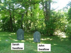
Ens John Swallow
| Birth | : | 12 Aug 1709 Chelmsford, Middlesex County, Massachusetts, USA |
| Death | : | 15 Feb 1776 Dunstable, Middlesex County, Massachusetts, USA |
| Burial | : | Fern Hill Cemetery, Menlo, Pacific County, USA |
| Coordinate | : | 46.6338997, -123.6585999 |
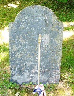
| Inscription | : | Here lies the body of ENSIGN JOHN SWALLOW who departed this life Feb. 5, 1776 aged 66 years, 5 mos., and 21 days Source: Nason, Elias "History of Dunstable, Massachusetts": A Mudge & Son, printers, Boston 1 |
| Description | : | John Swallow was the son of Ambrose, Jr. and Sarah (Barrett) Swallow, born in Chelmsford, Middlesex, Massachusetts 2 August 1709. He settled in the northern part of Groton, Middlesex, Massachusetts and in 1753 his farm and other lands were annexed to Dunstable, Middlesex, Massachusetts. He married 1st Deborah (?) who was the mother of two sons, John and Amaziah. He married 2nd, Sarah Nutting, daughter of Jonathan and Mary (Green) Nutting. She was the mother of eight children. He united with the church of Groton, 29 October 1732, and he and his wife, Sarah, were foundation members of... Read More |
frequently asked questions (FAQ):
-
Where is Ens John Swallow's memorial?
Ens John Swallow's memorial is located at: Fern Hill Cemetery, Menlo, Pacific County, USA.
-
When did Ens John Swallow death?
Ens John Swallow death on 15 Feb 1776 in Dunstable, Middlesex County, Massachusetts, USA
-
Where are the coordinates of the Ens John Swallow's memorial?
Latitude: 46.6338997
Longitude: -123.6585999
Family Members:
Spouse
Children
Flowers:


Nearby Cemetories:
1. Fern Hill Cemetery
Menlo, Pacific County, USA
Coordinate: 46.6338997, -123.6585999
2. Giesy Family Cemetery
Menlo, Pacific County, USA
Coordinate: 46.6446780, -123.6625170
3. Odd Fellows Cemetery
South Bend, Pacific County, USA
Coordinate: 46.6647130, -123.7541360
4. Riddell Street Cemetery
Raymond, Pacific County, USA
Coordinate: 46.6945200, -123.7358600
5. F O E 1631 Cemetery
Raymond, Pacific County, USA
Coordinate: 46.7006000, -123.7319000
6. Washington Cemetery
Raymond, Pacific County, USA
Coordinate: 46.7005997, -123.7319031
7. Maple Hill Cemetery
Lebam, Pacific County, USA
Coordinate: 46.5653150, -123.5671480
8. Fir Grove Cemetery
Lebam, Pacific County, USA
Coordinate: 46.5604910, -123.5548970
9. Holy Family Catholic Cemetery
Frances, Pacific County, USA
Coordinate: 46.5403270, -123.5000130
10. Campbell Family Cemetery
Frances, Pacific County, USA
Coordinate: 46.5346950, -123.4939790
11. North River Cemetery
Brooklyn, Pacific County, USA
Coordinate: 46.7750090, -123.4877010
12. Wilsonville Cemetery
Pacific County, USA
Coordinate: 46.6379710, -123.9387740
13. Bay Center Cemetery
Bay Center, Pacific County, USA
Coordinate: 46.5986490, -123.9355650
14. Vesta Cemetery
Vesta, Grays Harbor County, USA
Coordinate: 46.8301850, -123.5900460
15. Bay Center Pioneer Cemetery
Bay Center, Pacific County, USA
Coordinate: 46.6298850, -123.9538870
16. Saint Joseph Cemetery
Pe Ell, Lewis County, USA
Coordinate: 46.5732590, -123.3012070
17. Saint Josephs Catholic Cemetery
Pe Ell, Lewis County, USA
Coordinate: 46.5648880, -123.3031070
18. Forest Lawn Cemetery
Pe Ell, Lewis County, USA
Coordinate: 46.5649190, -123.3008280
19. Shoalwater Bay Indian Tribal Cemetery
Pacific County, USA
Coordinate: 46.7217040, -124.0152920
20. Dryad Cemetery
Dryad, Lewis County, USA
Coordinate: 46.6467667, -123.2665329
21. Oysterville Cemetery
Oysterville, Pacific County, USA
Coordinate: 46.5478670, -124.0337350
22. Salmon Creek Cemetery
Deep River, Wahkiakum County, USA
Coordinate: 46.3634000, -123.7164000
23. Deep River Cemetery
Deep River, Wahkiakum County, USA
Coordinate: 46.3587910, -123.6849890
24. Salmon Creek Cemetery Old
Wahkiakum County, USA
Coordinate: 46.3578630, -123.7178340