
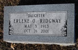
Erlene Ornba Kuhner Ridgway
| Birth | : | 3 May 1913 Clarence, Shelby County, Missouri, USA |
| Death | : | 26 Oct 2001 Clarence, Shelby County, Missouri, USA |
| Burial | : | Smithfield Memorial Park, Evanston South, Gawler, Australia |
| Coordinate | : | -34.6581280, 138.7140465 |
| Plot | : | AOUW Block 6 Row 5 Lot 37s |
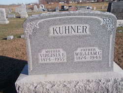
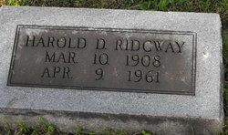
| Description | : | Obituary: Jefferson City News Tribune, Sunday, October 28, 2001 Erlene O. Ridgway, 88, Eldon, died Oct. 26, 2001, at Clarence Care Center. She was born May 3, 1913, a daughter of William Christian and Virginia Ellen Taylor Kuhner. She was married in 1937 to Harold Ridgway, who preceded her in death. She was married in 1954 to Marion Coats, who also preceded her in death. She graduated in 1933 from Clarence High School and attended Kirksville State Teachers College. She owned and operated a clothing store in Eldon for 50 years. She was an active member of Eldon United Methodist Church. Survivors... Read More |
frequently asked questions (FAQ):
-
Where is Erlene Ornba Kuhner Ridgway's memorial?
Erlene Ornba Kuhner Ridgway's memorial is located at: Smithfield Memorial Park, Evanston South, Gawler, Australia.
-
When did Erlene Ornba Kuhner Ridgway death?
Erlene Ornba Kuhner Ridgway death on 26 Oct 2001 in Clarence, Shelby County, Missouri, USA
-
Where are the coordinates of the Erlene Ornba Kuhner Ridgway's memorial?
Latitude: -34.6581280
Longitude: 138.7140465
Family Members:
Parent

Spouse
Siblings
Flowers:


Nearby Cemetories:
1. Smithfield Memorial Park
Evanston South, Gawler, Australia
Coordinate: -34.6581280, 138.7140465
2. Loos Cemetery
Buchfelde, Light Regional Council, Australia
Coordinate: -34.6070670, 138.7090900
3. Buchfelde Cemetery
Buchfelde, Light Regional Council, Australia
Coordinate: -34.6095060, 138.6931750
4. Uley Baptist Church Cemetery
Uleybury, Playford City, Australia
Coordinate: -34.6954070, 138.7575960
5. Angle Vale Methodist Cemetery
Angle Vale, Playford City, Australia
Coordinate: -34.6417580, 138.6421660
6. Stone Hill Wesleyan Methodist Cemetery
Gawler River, Light Regional Council, Australia
Coordinate: -34.6153450, 138.6595850
7. Holy Cross Anglican Church
Elizabeth, Salisbury City, Australia
Coordinate: -34.7147160, 138.6724910
8. Zoar Bible Christian Cemetery
Penfield, Playford City, Australia
Coordinate: -34.6825160, 138.6358430
9. One Tree Hill Uniting Church Cemetery
One Tree Hill, Playford City, Australia
Coordinate: -34.7185200, 138.7682710
10. Gawler East Anglican Churchyard
Gawler East, Gawler, Australia
Coordinate: -34.5935650, 138.7637550
11. Willaston General Cemetery
Willaston, Gawler, Australia
Coordinate: -34.5779870, 138.7417230
12. Angle Vale Carclew Primitive Methodist Cemetery
Penfield, Playford City, Australia
Coordinate: -34.6404900, 138.6140060
13. Sturton Family Cemetery
Penfield, Playford City, Australia
Coordinate: -34.7255460, 138.6375980
14. Little Para Wesleyan Cemetery
Hillbank, Playford City, Australia
Coordinate: -34.7479620, 138.6836570
15. Kangaroo Flat Methodist Cemetery
Kangaroo Flat, Light Regional Council, Australia
Coordinate: -34.5527800, 138.6922060
16. Concordia Pioneer Cemetery
Concordia, Barossa Council, Australia
Coordinate: -34.5748700, 138.8016100
17. Salisbury Pioneer Catholic Cemetery
Salisbury, Salisbury City, Australia
Coordinate: -34.7627130, 138.6520780
18. Golden Grove Cemetery
Golden Grove, Tea Tree Gully City, Australia
Coordinate: -34.7748502, 138.7318420
19. Salisbury Methodist Church Cemetery
Salisbury, Salisbury City, Australia
Coordinate: -34.7616800, 138.6452510
20. Bethesda Bible Christian Cemetery
Lewiston, District Council of Mallala, Australia
Coordinate: -34.6123460, 138.5811100
21. St. John's Churchyard
Salisbury, Salisbury City, Australia
Coordinate: -34.7644090, 138.6463600
22. Greenwith Uniting Church
Golden Grove, Tea Tree Gully City, Australia
Coordinate: -34.7849500, 138.7187400
23. Golden Grove Uniting Church
Golden Grove, Tea Tree Gully City, Australia
Coordinate: -34.7883129, 138.7091051
24. Salisbury Memorial Park
Salisbury, Salisbury City, Australia
Coordinate: -34.7737160, 138.6382070