
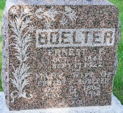

Ernest Frederick Boelter
| Birth | : | 1 Oct 1849 Mecklenburg-Vorpommern, Germany |
| Death | : | 17 Sep 1922 Walnut, Knox County, Nebraska, USA |
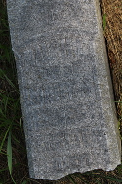
| Burial | : | Evergreen Cemetery, Miamiville, Clermont County, USA |
| Coordinate | : | 39.2113500, -84.3098300 |
| Description | : | Ernest F. Boelter, born in Teschendorf, Germany, October 1, 1846, came to America in 1870. He spent four years in Wisconsin, Then came to Nebraska and settled in Knox County, west of Walnut near a brother, Karl F., who had come to America a few years previous from Prussia. Ernest became a citizen of the United States April 25, 1883. His brother, Karl, also known as Charlie, became a citizen of the United States, October 17, 1881. Karl never married. He was born January 26, 1841 and died August 9, 1906. Ernest was married April 7, 1881 to Mary Odren,... Read More |
frequently asked questions (FAQ):
-
Where is Ernest Frederick Boelter's memorial?
Ernest Frederick Boelter's memorial is located at: Evergreen Cemetery, Miamiville, Clermont County, USA.
-
When did Ernest Frederick Boelter death?
Ernest Frederick Boelter death on 17 Sep 1922 in Walnut, Knox County, Nebraska, USA
-
Where are the coordinates of the Ernest Frederick Boelter's memorial?
Latitude: 39.2113500
Longitude: -84.3098300
Family Members:
Spouse

Children

Flowers:


Nearby Cemetories:
1. Evergreen Cemetery
Miamiville, Clermont County, USA
Coordinate: 39.2113500, -84.3098300
2. Waldschmidt Cemetery
Camp Dennison, Hamilton County, USA
Coordinate: 39.1944900, -84.2882200
3. Laurel Memorial Gardens
Symmes, Hamilton County, USA
Coordinate: 39.2352982, -84.3125000
4. Ranson Family Cemetery
Top-of-the-Ridge, Clermont County, USA
Coordinate: 39.2077220, -84.2719890
5. Brown Family Cemetery
Top-of-the-Ridge, Clermont County, USA
Coordinate: 39.1968980, -84.2695320
6. Milford Cemetery
Milford, Clermont County, USA
Coordinate: 39.1795550, -84.2908500
7. Milford First United Methodist Church Columbarium
Milford, Clermont County, USA
Coordinate: 39.1768880, -84.2910680
8. Jewish Cemeteries of Greater Cincinnati – Loveland
Loveland, Clermont County, USA
Coordinate: 39.2281970, -84.2641830
9. Concord Methodist Episcopal Cemetery
Sundale, Clermont County, USA
Coordinate: 39.2318820, -84.2599380
10. Hopewell Cemetery
Montgomery, Hamilton County, USA
Coordinate: 39.2439003, -84.3482971
11. Covalt Cemetery
Terrace Park, Hamilton County, USA
Coordinate: 39.1671400, -84.3028080
12. Saint Thomas Episcopal Church Columbarium
Terrace Park, Hamilton County, USA
Coordinate: 39.1666300, -84.3029760
13. Indian Hill Episcopal Presbyterian Churchyard
Cincinnati, Hamilton County, USA
Coordinate: 39.1748880, -84.3441490
14. Knox Presbyterian Church Columbarium
Hyde Park, Hamilton County, USA
Coordinate: 39.1846081, -84.3569411
15. Montgomery United Jewish Cemetery
Montgomery, Hamilton County, USA
Coordinate: 39.2441700, -84.3502800
16. Hetzler Family Cemetery
Madeira, Hamilton County, USA
Coordinate: 39.1914024, -84.3625946
17. Chapel of the Rose and Columbarium
Montgomery, Hamilton County, USA
Coordinate: 39.2473160, -84.3460530
18. Jesuit Cemetery
Milford, Clermont County, USA
Coordinate: 39.1655400, -84.2932700
19. Old Indian Hill Baptist Churchyard
Indian Hill, Hamilton County, USA
Coordinate: 39.1628685, -84.3127518
20. Greenlawn Cemetery
Milford, Clermont County, USA
Coordinate: 39.1706009, -84.2758026
21. Saint Andrews Cemetery
Milford, Clermont County, USA
Coordinate: 39.1632996, -84.2941971
22. Kerr Cemetery
Symmes Township, Hamilton County, USA
Coordinate: 39.2574600, -84.2832600
23. Mulberry Cemetery
Milford, Clermont County, USA
Coordinate: 39.1947784, -84.2469864
24. Apgar Farm Cemetery
Loveland, Hamilton County, USA
Coordinate: 39.2622299, -84.2948761