
| Birth | : | 12 Aug 1871 Teeds Grove, Clinton County, Iowa, USA |
| Death | : | 25 Jan 1951 Turner County, South Dakota, USA |
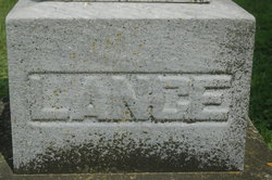
| Burial | : | Mount Hope Cemetery, Ashland, Ashland County, USA |
| Coordinate | : | 46.5621986, -90.9039001 |
| Description | : | Ernest Lange, son of Christian and Margaret Lange was born on Aug. 12, 1871 in Teeds Grove, IA. He passed away Jan. 25, 1951 at the age of 79 years, 5 months and 13 days. On Oct. 12, 1898 he was united in marriage to Anna Jensen. They lived in eastern Iowa for 7 years before coming to South Dakota where he farmed for a number of years in Turner County before moving to Hurley, where he resided until his death. To this union seven children were born, Mrs. Evalena Benson, Mrs. Leona Allen, Ray and Edward, all of Hurley, Virtus of Sioux Falls,... Read More |
frequently asked questions (FAQ):
-
Where is Ernest Lange's memorial?
Ernest Lange's memorial is located at: Mount Hope Cemetery, Ashland, Ashland County, USA.
-
When did Ernest Lange death?
Ernest Lange death on 25 Jan 1951 in Turner County, South Dakota, USA
-
Where are the coordinates of the Ernest Lange's memorial?
Latitude: 46.5621986
Longitude: -90.9039001
Family Members:
Parent

Spouse

Siblings
Children
Flowers:


Nearby Cemetories:
1. Mount Hope Cemetery
Ashland, Ashland County, USA
Coordinate: 46.5621986, -90.9039001
2. Saint Agnes Cemetery
Ashland, Ashland County, USA
Coordinate: 46.5614014, -90.9075012
3. B'Nai Israel Cemetery
Ashland, Ashland County, USA
Coordinate: 46.5600014, -90.9116974
4. Heitsch Family Burial Plot
Barksdale, Bayfield County, USA
Coordinate: 46.6315661, -90.9560996
5. Church Corner Cemetery
Washburn, Bayfield County, USA
Coordinate: 46.6595000, -90.9889000
6. Moquah National Cemetery
Moquah, Bayfield County, USA
Coordinate: 46.5702860, -91.0718390
7. Moquah Cemetery
Moquah, Bayfield County, USA
Coordinate: 46.5701980, -91.0731530
8. Woodland Cemetery
Washburn, Bayfield County, USA
Coordinate: 46.6845100, -90.9049800
9. Calvary Cemetery
Washburn, Bayfield County, USA
Coordinate: 46.6852989, -90.9008026
10. Saints Peter and Paul Catholic Cemetery
Moquah, Bayfield County, USA
Coordinate: 46.5698013, -91.0842972
11. Saint Peters Cemetery
Benoit, Bayfield County, USA
Coordinate: 46.5236015, -91.0781021
12. Old Apostolic Lutheran Cemetery
Marengo, Ashland County, USA
Coordinate: 46.4408640, -90.8473530
13. Bad River Cemetery
Odanah, Ashland County, USA
Coordinate: 46.5992100, -90.7208900
14. Saint Anne Catholic Cemetery
Sanborn, Ashland County, USA
Coordinate: 46.4294281, -90.9071426
15. Benoit Cemetery
Benoit, Bayfield County, USA
Coordinate: 46.5026016, -91.0794983
16. Old Calvary Cemetery
Washburn, Bayfield County, USA
Coordinate: 46.7072906, -90.8947830
17. Fish Creek Cemetery
Ino, Bayfield County, USA
Coordinate: 46.5241165, -91.1252823
18. Moland Lutheran Church Cemetery
Mason, Bayfield County, USA
Coordinate: 46.4131012, -90.9897995
19. Mason Cemetery
Mason, Bayfield County, USA
Coordinate: 46.4401800, -91.0555800
20. Maple Grove Cemetery
Marengo, Ashland County, USA
Coordinate: 46.3852997, -90.8606033
21. Moe Cemetery
Mason, Bayfield County, USA
Coordinate: 46.3789200, -90.9498900
22. Saint Florians Cemetery
Ino, Bayfield County, USA
Coordinate: 46.5161438, -91.1750412
23. Birch Lake Cemetery
Mason, Bayfield County, USA
Coordinate: 46.3569603, -90.9666595
24. Mount Hope Cemetery
High Bridge, Ashland County, USA
Coordinate: 46.3859700, -90.7353300