

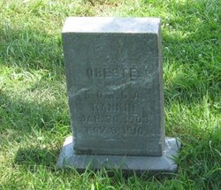
Ernest Oliver Rankin
| Birth | : | 3 Sep 1872 Attica, Marion County, Iowa, USA |
| Death | : | 29 Mar 1916 Knoxville, Marion County, Iowa, USA |
| Burial | : | Liverpool Road Cemetery, Birkdale, Metropolitan Borough of Sefton, England |
| Coordinate | : | 53.6083620, -3.0257140 |
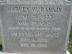
| Description | : | Ernest was the son of Harvey W. Rankin & Violette Henderson. He was married to Clara Alice Maddy. |
frequently asked questions (FAQ):
-
Where is Ernest Oliver Rankin's memorial?
Ernest Oliver Rankin's memorial is located at: Liverpool Road Cemetery, Birkdale, Metropolitan Borough of Sefton, England.
-
When did Ernest Oliver Rankin death?
Ernest Oliver Rankin death on 29 Mar 1916 in Knoxville, Marion County, Iowa, USA
-
Where are the coordinates of the Ernest Oliver Rankin's memorial?
Latitude: 53.6083620
Longitude: -3.0257140
Family Members:
Parent

Spouse
Siblings

Children
Flowers:


Nearby Cemetories:
1. Liverpool Road Cemetery
Birkdale, Metropolitan Borough of Sefton, England
Coordinate: 53.6083620, -3.0257140
2. Sacred Heart RC Cemetery
Birkdale, Metropolitan Borough of Sefton, England
Coordinate: 53.6066100, -3.0270100
3. Christ Church Churchyard
Southport, Metropolitan Borough of Sefton, England
Coordinate: 53.6327778, -2.9953770
4. Duke Street Cemetery
Southport, Metropolitan Borough of Sefton, England
Coordinate: 53.6343536, -2.9993131
5. Ardwick Cemetery
Ardwick, Metropolitan Borough of Manchester, England
Coordinate: 53.6302778, -2.9900000
6. Southport Crematorium
Scarisbrick, West Lancashire District, England
Coordinate: 53.6235810, -2.9600210
7. Holy Trinity Church
Southport, Metropolitan Borough of Sefton, England
Coordinate: 53.6503800, -2.9969150
8. St. Marie on the Sands
Southport, Metropolitan Borough of Sefton, England
Coordinate: 53.6524320, -3.0023440
9. St. Peter's Churchyard
Formby, Metropolitan Borough of Sefton, England
Coordinate: 53.5663834, -3.0594721
10. St. Cuthbert's Churchyard
Halsall, West Lancashire District, England
Coordinate: 53.5852140, -2.9529650
11. St. Mark Churchyard
Scarisbrick, West Lancashire District, England
Coordinate: 53.6134600, -2.9403800
12. Our Lady Of Compassion RC Churchyard
Formby, Metropolitan Borough of Sefton, England
Coordinate: 53.5574060, -3.0575020
13. St. Michael and All Angels Churchyard
Great Altcar, Metropolitan Borough of Sefton, England
Coordinate: 53.5507770, -3.0279540
14. Emmanuel Parish Church
Southport, Metropolitan Borough of Sefton, England
Coordinate: 53.6604534, -2.9748117
15. Emmanuel Church Garden of Remembrance
North Meols, West Lancashire District, England
Coordinate: 53.6607130, -2.9753420
16. St. Elizabeth's Churchyard
Scarisbrick, West Lancashire District, England
Coordinate: 53.6124460, -2.9206340
17. St Cuthberts Churchyard
Southport, Metropolitan Borough of Sefton, England
Coordinate: 53.6603230, -2.9620310
18. St. Luke Churchyard
Formby, Metropolitan Borough of Sefton, England
Coordinate: 53.5520000, -3.0869800
19. St Thomas Churchyard
Lydiate, Metropolitan Borough of Sefton, England
Coordinate: 53.5443480, -2.9621640
20. Our Lady's Roman Catholic Churchyard
Lydiate, Metropolitan Borough of Sefton, England
Coordinate: 53.5396850, -2.9599940
21. Saint John Crossens Churchyard
Crossens, Metropolitan Borough of Sefton, England
Coordinate: 53.6733410, -2.9478740
22. St Catherine Churchyard
Lydiate, Metropolitan Borough of Sefton, England
Coordinate: 53.5368000, -2.9612660
23. Ince Blundell Cemetery
Ince Blundell, Metropolitan Borough of Sefton, England
Coordinate: 53.5213570, -3.0208750
24. Christ Churchyard
Aughton, West Lancashire District, England
Coordinate: 53.5583510, -2.9046990