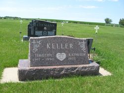
| Birth | : | 3 Apr 1925 Glencross, Dewey County, South Dakota, USA |
| Death | : | 18 May 2006 Mobridge, Walworth County, South Dakota, USA |
| Burial | : | Deer Creek United Methodist Church Cemetery, Forest Hill, Harford County, USA |
| Coordinate | : | 39.6130981, -76.3522034 |
| Description | : | Ervin Markus Keller was a man of many skills. He was a dairy farmer. He was a knowledgeable carpenter, but he couldn't always buy the tools he needed. He was known to make tools he needed including a machine that twisted twine into rope. Although he finished school early in his teens, he was an avid reader and knew there was much more to learn about the world. Ervin was a founding director of the TC&G Water Association and served on the board for many years. He was also a member of the Board of Directors of the Glencross Co-op. The... Read More |
frequently asked questions (FAQ):
-
Where is Ervin Markus Keller's memorial?
Ervin Markus Keller's memorial is located at: Deer Creek United Methodist Church Cemetery, Forest Hill, Harford County, USA.
-
When did Ervin Markus Keller death?
Ervin Markus Keller death on 18 May 2006 in Mobridge, Walworth County, South Dakota, USA
-
Where are the coordinates of the Ervin Markus Keller's memorial?
Latitude: 39.6130981
Longitude: -76.3522034
Family Members:
Parent
Spouse
Siblings
Flowers:
Nearby Cemetories:
1. Deer Creek United Methodist Church Cemetery
Forest Hill, Harford County, USA
Coordinate: 39.6130981, -76.3522034
2. Mount Tabor United Methodist Church Cemetery
Bel Air, Harford County, USA
Coordinate: 39.5863991, -76.3308029
3. Centre Cemetery
Forest Hill, Harford County, USA
Coordinate: 39.5963700, -76.3899500
4. Hickory Baptist Church Cemetery
Forest Hill, Harford County, USA
Coordinate: 39.5779600, -76.3452000
5. Baptist View Regular Baptist Church Cemetery
Forest Hill, Harford County, USA
Coordinate: 39.6012900, -76.3964900
6. Forest Friends Meeting Cemetery
Forest Hill, Harford County, USA
Coordinate: 39.5837212, -76.3816452
7. Saint Ignatius Cemetery
Hickory, Harford County, USA
Coordinate: 39.5736008, -76.3550034
8. Emory United Methodist Church Cemetery
Street, Harford County, USA
Coordinate: 39.6511002, -76.3367004
9. Clarks United Methodist Church Cemetery
Bel Air, Harford County, USA
Coordinate: 39.6036100, -76.3004600
10. Dallam-Webster Family Cemetery
Bel Air, Harford County, USA
Coordinate: 39.5722400, -76.3339100
11. Christ Church Cemetery
Forest Hill, Harford County, USA
Coordinate: 39.5744019, -76.3874969
12. Welcome Home Freewill Baptist Church Cemetery
Bel Air, Harford County, USA
Coordinate: 39.5689000, -76.3244800
13. Thomas Run Church Cemetery
Churchville, Harford County, USA
Coordinate: 39.5935000, -76.2923300
14. Ascension Cemetery
Street, Harford County, USA
Coordinate: 39.6467018, -76.2928009
15. Highland Presbyterian Church Cemetery
Street, Harford County, USA
Coordinate: 39.6675700, -76.3790100
16. Chestnut Grove Cemetery
Street, Harford County, USA
Coordinate: 39.6493988, -76.4156036
17. Fairview Cemetery
Harford County, USA
Coordinate: 39.5805900, -76.4212600
18. Southampton Farm Cemetery
Southampton, Harford County, USA
Coordinate: 39.5486600, -76.3344700
19. Bel Air Memorial Gardens
Bel Air, Harford County, USA
Coordinate: 39.5468000, -76.3617900
20. Holy Cross Episcopal Church Cemetery
Burns Corner, Harford County, USA
Coordinate: 39.6653000, -76.4067800
21. William Watters United Methodist Church Cemetery
Coopstown, Harford County, USA
Coordinate: 39.6011009, -76.4408035
22. Broad Creek Cemetery
Scarboro, Harford County, USA
Coordinate: 39.6605988, -76.2846985
23. Saint Matthews Lutheran Church Columbarium
Bel Air, Harford County, USA
Coordinate: 39.5440430, -76.3268720
24. Trappe Missionary Baptist Church Cemetery
Darlington, Harford County, USA
Coordinate: 39.6171989, -76.2589035


