
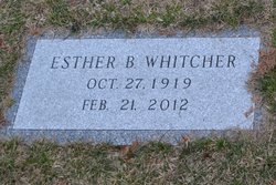
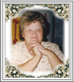
Esther Irene “Gram” Ball Whitcher
| Birth | : | 27 Oct 1919 Landaff, Grafton County, New Hampshire, USA |
| Death | : | 21 Feb 2012 Laconia, Belknap County, New Hampshire, USA |
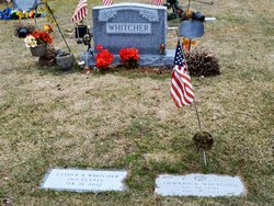
| Burial | : | High Street Cemetery, Glencliff, Grafton County, USA |
| Coordinate | : | 43.9851100, -71.8913900 |
| Description | : | Warren, NH – Esther Irene Whitcher, 92, of Lake Tarleton Road, died February 21, 2012 at Lakes Region General Hospital, Laconia, NH. Esther was affectionately known to all in the community as "Gram." She was born in Landaff, NH, October 27, 1919, a daughter of Bert and Eva (Moulton) Ball. For several years she worked at the former Lake Tarleton Club in Piermont, and later retired from the NH Home for the Elderly in Glencliff. Esther was a member of the Warren United Methodist Church, a member of more than 50 years of the Pythian Sisters, and a member of the... Read More |
frequently asked questions (FAQ):
-
Where is Esther Irene “Gram” Ball Whitcher's memorial?
Esther Irene “Gram” Ball Whitcher's memorial is located at: High Street Cemetery, Glencliff, Grafton County, USA.
-
When did Esther Irene “Gram” Ball Whitcher death?
Esther Irene “Gram” Ball Whitcher death on 21 Feb 2012 in Laconia, Belknap County, New Hampshire, USA
-
Where are the coordinates of the Esther Irene “Gram” Ball Whitcher's memorial?
Latitude: 43.9851100
Longitude: -71.8913900
Family Members:
Spouse

Children
Flowers:


Nearby Cemetories:
1. High Street Cemetery
Glencliff, Grafton County, USA
Coordinate: 43.9851100, -71.8913900
2. Oliverian Road Cemetery
Benton, Grafton County, USA
Coordinate: 43.9978145, -71.9209265
3. Pine Hill Cemetery
Warren, Grafton County, USA
Coordinate: 43.9370003, -71.8929977
4. Lund Cemetery
Warren, Grafton County, USA
Coordinate: 43.9882800, -71.9589200
5. Warren Village Cemetery
Warren, Grafton County, USA
Coordinate: 43.9326200, -71.8917600
6. Number 6 Cemetery
East Haverhill, Grafton County, USA
Coordinate: 44.0326400, -71.9518600
7. East Piermont Cemetery
Piermont, Grafton County, USA
Coordinate: 43.9438890, -71.9689890
8. Rodimon-Cross Cemetery
Piermont, Grafton County, USA
Coordinate: 43.9901100, -71.9924500
9. Clough Cemetery
Warren, Grafton County, USA
Coordinate: 43.9090200, -71.8878800
10. East Haverhill Cemetery
East Haverhill, Grafton County, USA
Coordinate: 44.0289688, -71.9889297
11. Brown Farmstead Cemetery
Benton, Grafton County, USA
Coordinate: 44.0778000, -71.8420830
12. East Side Cemetery
Wentworth, Grafton County, USA
Coordinate: 43.8837000, -71.9002200
13. Clay Hollow Cemetery
Piermont, Grafton County, USA
Coordinate: 43.9597220, -72.0333330
14. East Orford Cemetery
Orford, Grafton County, USA
Coordinate: 43.9096900, -72.0032600
15. East Cemetery
Benton, Grafton County, USA
Coordinate: 44.0985985, -71.8846970
16. Center Haverhill Cemetery
Center Haverhill, Grafton County, USA
Coordinate: 44.0770650, -71.9868740
17. Foster Cemetery
Wentworth, Grafton County, USA
Coordinate: 43.8708100, -71.9127800
18. Wentworth Village Cemetery
Wentworth, Grafton County, USA
Coordinate: 43.8707280, -71.9128410
19. West Cemetery
Benton, Grafton County, USA
Coordinate: 44.1033700, -71.9014000
20. Blake Cemetery
Stinson Lake, Grafton County, USA
Coordinate: 43.8827780, -71.7975000
21. Ladd Street Cemetery
Haverhill, Grafton County, USA
Coordinate: 44.0439600, -72.0532800
22. Abbott Cemetery
North Haverhill, Grafton County, USA
Coordinate: 44.0821730, -72.0186420
23. Cedar Grove Cemetery
Piermont, Grafton County, USA
Coordinate: 43.9720300, -72.0813400
24. South Lawn Cemetery
Piermont, Grafton County, USA
Coordinate: 43.9667600, -72.0812500