

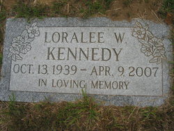
Loralee Whitcher Kennedy
| Birth | : | 13 Oct 1939 Warren, Grafton County, New Hampshire, USA |
| Death | : | 9 Apr 2007 Manchester, Hillsborough County, New Hampshire, USA |
| Burial | : | High Street Cemetery, Glencliff, Grafton County, USA |
| Coordinate | : | 43.9851100, -71.8913900 |
| Description | : | Mrs. Loralee Kennedy, 67, of Island Road Warren, died, Monday, April 09th, 2007 at Catholic Medical Center, in Manchester. Mrs. Kennedy was born in Warren, on October 13, 1939, the daughter of the late Edward L. and Esther (Ball) Whitcher. She attended Orford High School. Mrs. Kennedy worked as a Waitress at Moosilauke Inn, she also was employed several years at Glencliff Home for the Elderly. She was co-owner of Moosilauke View Restaurant, for several years. Most recently she worked as a clerk for Baker River Market as well as the Warren Village Market. She was a member of the Warren... Read More |
frequently asked questions (FAQ):
-
Where is Loralee Whitcher Kennedy's memorial?
Loralee Whitcher Kennedy's memorial is located at: High Street Cemetery, Glencliff, Grafton County, USA.
-
When did Loralee Whitcher Kennedy death?
Loralee Whitcher Kennedy death on 9 Apr 2007 in Manchester, Hillsborough County, New Hampshire, USA
-
Where are the coordinates of the Loralee Whitcher Kennedy's memorial?
Latitude: 43.9851100
Longitude: -71.8913900
Family Members:
Parent

Spouse

Siblings
Children
Flowers:


Nearby Cemetories:
1. High Street Cemetery
Glencliff, Grafton County, USA
Coordinate: 43.9851100, -71.8913900
2. Oliverian Road Cemetery
Benton, Grafton County, USA
Coordinate: 43.9978145, -71.9209265
3. Pine Hill Cemetery
Warren, Grafton County, USA
Coordinate: 43.9370003, -71.8929977
4. Lund Cemetery
Warren, Grafton County, USA
Coordinate: 43.9882800, -71.9589200
5. Warren Village Cemetery
Warren, Grafton County, USA
Coordinate: 43.9326200, -71.8917600
6. Number 6 Cemetery
East Haverhill, Grafton County, USA
Coordinate: 44.0326400, -71.9518600
7. East Piermont Cemetery
Piermont, Grafton County, USA
Coordinate: 43.9438890, -71.9689890
8. Rodimon-Cross Cemetery
Piermont, Grafton County, USA
Coordinate: 43.9901100, -71.9924500
9. Clough Cemetery
Warren, Grafton County, USA
Coordinate: 43.9090200, -71.8878800
10. East Haverhill Cemetery
East Haverhill, Grafton County, USA
Coordinate: 44.0289688, -71.9889297
11. Brown Farmstead Cemetery
Benton, Grafton County, USA
Coordinate: 44.0778000, -71.8420830
12. East Side Cemetery
Wentworth, Grafton County, USA
Coordinate: 43.8837000, -71.9002200
13. Clay Hollow Cemetery
Piermont, Grafton County, USA
Coordinate: 43.9597220, -72.0333330
14. East Orford Cemetery
Orford, Grafton County, USA
Coordinate: 43.9096900, -72.0032600
15. East Cemetery
Benton, Grafton County, USA
Coordinate: 44.0985985, -71.8846970
16. Center Haverhill Cemetery
Center Haverhill, Grafton County, USA
Coordinate: 44.0770650, -71.9868740
17. Foster Cemetery
Wentworth, Grafton County, USA
Coordinate: 43.8708100, -71.9127800
18. Wentworth Village Cemetery
Wentworth, Grafton County, USA
Coordinate: 43.8707280, -71.9128410
19. West Cemetery
Benton, Grafton County, USA
Coordinate: 44.1033700, -71.9014000
20. Blake Cemetery
Stinson Lake, Grafton County, USA
Coordinate: 43.8827780, -71.7975000
21. Ladd Street Cemetery
Haverhill, Grafton County, USA
Coordinate: 44.0439600, -72.0532800
22. Abbott Cemetery
North Haverhill, Grafton County, USA
Coordinate: 44.0821730, -72.0186420
23. Cedar Grove Cemetery
Piermont, Grafton County, USA
Coordinate: 43.9720300, -72.0813400
24. South Lawn Cemetery
Piermont, Grafton County, USA
Coordinate: 43.9667600, -72.0812500