
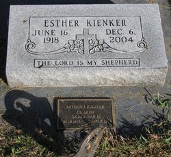
Esther Irene Moerer Kienker
| Birth | : | 16 Jun 1918 Johnson, Nemaha County, Nebraska, USA |
| Death | : | 6 Dec 2004 Auburn, Nemaha County, Nebraska, USA |
| Burial | : | Otaki Public Cemetery, Otaki, Kapiti Coast District, New Zealand |
| Coordinate | : | -40.7528152, 175.1497955 |
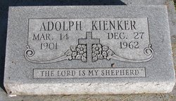
| Description | : | Esther Irene Moerer was the 4th child of August Franz Moerer. She was bapt. July 7, 1918 at St.Paul(Hickory Grove) Lutheran Church rural Auburn, NE. Her sponsors were Louise Stutheit and Anna Moerer. She died at the age of 86 years. She married Feb. 10, 1950, Johnson, Nemaha, NE. to Adolph Henry Kienker. b. 1900 and d. 1962. They had 3 children. Linda, Susan and Sandra. Esther and Adolph lived in Johnson, NE. |
frequently asked questions (FAQ):
-
Where is Esther Irene Moerer Kienker's memorial?
Esther Irene Moerer Kienker's memorial is located at: Otaki Public Cemetery, Otaki, Kapiti Coast District, New Zealand.
-
When did Esther Irene Moerer Kienker death?
Esther Irene Moerer Kienker death on 6 Dec 2004 in Auburn, Nemaha County, Nebraska, USA
-
Where are the coordinates of the Esther Irene Moerer Kienker's memorial?
Latitude: -40.7528152
Longitude: 175.1497955
Family Members:
Parent
Spouse
Siblings
Flowers:


Nearby Cemetories:
1. Otaki Public Cemetery
Otaki, Kapiti Coast District, New Zealand
Coordinate: -40.7528152, 175.1497955
2. Pukekaraka Cemetery
Otaki, Kapiti Coast District, New Zealand
Coordinate: -40.7453310, 175.1434230
3. Otaki Catholic Cemetery
Otaki, Kapiti Coast District, New Zealand
Coordinate: -40.7453400, 175.1426220
4. Rangiatea Churchyard
Otaki, Kapiti Coast District, New Zealand
Coordinate: -40.7499200, 175.1375800
5. Manakau Cemetery
Manakau, Horowhenua District, New Zealand
Coordinate: -40.7289340, 175.2067100
6. Kuku Māori Cemetery
Ohau, Horowhenua District, New Zealand
Coordinate: -40.6743300, 175.2402000
7. Waikanae Cemetery
Waikanae, Kapiti Coast District, New Zealand
Coordinate: -40.8678660, 175.0513240
8. Takamore Urupā
Waikanae Beach, Kapiti Coast District, New Zealand
Coordinate: -40.8721430, 175.0295190
9. Old Levin Cemetery
Levin, Horowhenua District, New Zealand
Coordinate: -40.6248570, 175.2710830
10. McDonald Family Cemetery
Hokio, Horowhenua District, New Zealand
Coordinate: -40.6038400, 175.2331650
11. Arapawaiti Cemetery Reserve
Paraparaumu Beach, Kapiti Coast District, New Zealand
Coordinate: -40.8811810, 175.0047520
12. Paraparaumu Beach Cemetery
Paraparaumu Beach, Kapiti Coast District, New Zealand
Coordinate: -40.8965800, 174.9862800
13. Avenue Cemetery
Levin, Horowhenua District, New Zealand
Coordinate: -40.5974007, 175.2957001
14. Awa Tapu Cemetery
Paraparaumu, Kapiti Coast District, New Zealand
Coordinate: -40.9328870, 175.0122070
15. Puaotapu Cemetery
Koputaroa, Horowhenua District, New Zealand
Coordinate: -40.5602300, 175.3522700
16. MacKay Family Cemetery
Kapiti Coast District, New Zealand
Coordinate: -40.9726800, 174.9833330
17. Mira Family Urupā
Paraparaumu, Kapiti Coast District, New Zealand
Coordinate: -40.9753380, 174.9643460
18. Shannon Cemetery
Shannon, Horowhenua District, New Zealand
Coordinate: -40.5476570, 175.4006020
19. Poutu (Shannon) Marae Cemetery
Moutoa, Horowhenua District, New Zealand
Coordinate: -40.5222650, 175.4003673
20. Foxton Cemetery
Foxton, Horowhenua District, New Zealand
Coordinate: -40.4800880, 175.3133440
21. Ihakara Gardens
Foxton, Horowhenua District, New Zealand
Coordinate: -40.4702980, 175.2815650
22. David Leary Memorial
Eketahuna, Tararua District, New Zealand
Coordinate: -40.7079188, 175.5836626
23. Akatarawa Cemetery
Upper Hutt City, New Zealand
Coordinate: -41.0876320, 175.1025870
24. Pukerua Bay Urupā
Pukerua Bay, Porirua City, New Zealand
Coordinate: -41.0300425, 174.8969530