
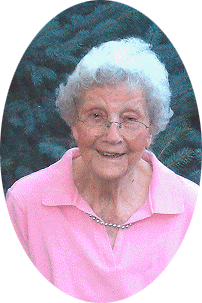
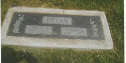
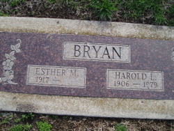
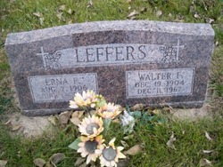
Esther Mabel Leffers Bryan
| Birth | : | 20 Aug 1917 Creston, Platte County, Nebraska, USA |
| Death | : | 14 May 2010 Columbus, Platte County, Nebraska, USA |
| Burial | : | Edge Cemetery, Whitesville, Daviess County, USA |
| Coordinate | : | 37.6491670, -86.8883330 |
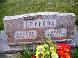
| Description | : | Daughter of August and Meta (Kruse) Leffers. She attended St. John's Lutheran Church (LCMS) where she was baptized, confirmed, and attended grade school. On September 27, 1940, Esther was united in marriage to Harold Bryan in Fremont, Nebraska. The couple made their home in Columbus. Esther enjoyed playing cards, gardening, fishing, and needle work. She was a member of Immanuel Lutheran Church where she had been a member of the Ladies Missionary League and the Sewing Circle. Esther enjoyed traveling and the beach. She had a love for the out of doors... Read More |
frequently asked questions (FAQ):
-
Where is Esther Mabel Leffers Bryan's memorial?
Esther Mabel Leffers Bryan's memorial is located at: Edge Cemetery, Whitesville, Daviess County, USA.
-
When did Esther Mabel Leffers Bryan death?
Esther Mabel Leffers Bryan death on 14 May 2010 in Columbus, Platte County, Nebraska, USA
-
Where are the coordinates of the Esther Mabel Leffers Bryan's memorial?
Latitude: 37.6491670
Longitude: -86.8883330
Family Members:
Parent

Spouse
Siblings


Flowers:


Nearby Cemetories:
1. Edge Cemetery
Whitesville, Daviess County, USA
Coordinate: 37.6491670, -86.8883330
2. Saint Mary of the Woods Cemetery
Whitesville, Daviess County, USA
Coordinate: 37.6605988, -86.8711014
3. Passionist Monastery Cemetery
Whitesville, Daviess County, USA
Coordinate: 37.6674350, -86.9092460
4. Barnetts Knob Cemetery
Whitesville, Daviess County, USA
Coordinate: 37.6753006, -86.8578033
5. Hendrix Cemetery
Ohio County, USA
Coordinate: 37.6557800, -86.8402300
6. Cates Cemetery
Whitesville, Daviess County, USA
Coordinate: 37.6819000, -86.8574982
7. Howard Family Cemetery
Fordsville, Ohio County, USA
Coordinate: 37.6636900, -86.8398890
8. Friendship Baptist Church Cemetery
Philpot, Daviess County, USA
Coordinate: 37.6520600, -86.9565100
9. Antioch Cemetery
Adaburg, Ohio County, USA
Coordinate: 37.5969300, -86.8624600
10. Jackson Cemetery
Masonville, Daviess County, USA
Coordinate: 37.6397018, -86.9593964
11. Hardin Family Cemetery North
Deanefield, Ohio County, USA
Coordinate: 37.6513888, -86.8136110
12. Hardin Cemetery
Deanefield, Ohio County, USA
Coordinate: 37.6450000, -86.8133330
13. Ellis Cemetery
Ohio County, USA
Coordinate: 37.6767006, -86.8191986
14. Old Bells Run Cemetery
Bells Run, Ohio County, USA
Coordinate: 37.5937400, -86.9280300
15. Adaburg Baptist Church Cemetery
Adaburg, Ohio County, USA
Coordinate: 37.5916800, -86.8524900
16. Bell's Run Cemetery
Bells Run, Ohio County, USA
Coordinate: 37.5929500, -86.9293900
17. Deanefield Cemetery
Deanefield, Ohio County, USA
Coordinate: 37.6611730, -86.8031970
18. Bellamy Cemetery
Ohio County, USA
Coordinate: 37.6397018, -86.8016968
19. Karn Family Cemetery
Philpot, Daviess County, USA
Coordinate: 37.7097740, -86.9388123
20. Karn's Grove Baptist Church Cemetery
Philpot, Daviess County, USA
Coordinate: 37.7102000, -86.9390600
21. Aetnaville Cemetery
Aetnaville, Ohio County, USA
Coordinate: 37.6780464, -86.7946315
22. Union Grove Cemetery
Bells Run, Ohio County, USA
Coordinate: 37.5710080, -86.9119000
23. Graves Family Cemetery
Ohio County, USA
Coordinate: 37.5919912, -86.9651932
24. Sugar Grove Baptist Church Cemetery
Fordsville, Ohio County, USA
Coordinate: 37.6169100, -86.7896500