
| Birth | : | 19 Jun 1902 Minden, Kearney County, Nebraska, USA |
| Death | : | 2 Jul 2000 Horseshoe Bend, Izard County, Arkansas, USA |
| Burial | : | Pawnee City Cemetery, Pawnee City, Pawnee County, USA |
| Coordinate | : | 40.1109009, -96.1608810 |
| Plot | : | Hazel Hill 6- 6- 12 |
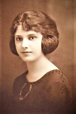
| Description | : | Married to Ross Morrison Barr in 1925. Suggested edit: Ethel Irene Barr, 98, Horseshoe Bend, Ark., widow of Ross, died Sunday July 2, 2000. Born, Minden. Survivors: brothers, Clifford Jorgensen, Lincoln, Gilbert Jorgensen, Cambria, Calif.; sisters, Marjorie Clark, Los Gatos, Calif., Jeanette Frasier, Fort Collins, Colo., Carol Tempe, Pinehurst, N.C., Jane Wulf, Houston. Services: 10 a.m. Wednesday, United Methodist Church, Horseshoe Bend, Ark. Burial: 10:30 a.m. Friday, Pawnee Cemetery, Pawnee City. Wherry Mortuary, Pawnee City. Lincoln Journal Star (NE) - Tuesday, July 4, 2000 Contributor: Amy Caddell (46939056) • [email protected] |
frequently asked questions (FAQ):
-
Where is Ethel Irene Jorgensen Barr's memorial?
Ethel Irene Jorgensen Barr's memorial is located at: Pawnee City Cemetery, Pawnee City, Pawnee County, USA.
-
When did Ethel Irene Jorgensen Barr death?
Ethel Irene Jorgensen Barr death on 2 Jul 2000 in Horseshoe Bend, Izard County, Arkansas, USA
-
Where are the coordinates of the Ethel Irene Jorgensen Barr's memorial?
Latitude: 40.1109009
Longitude: -96.1608810
Family Members:
Parent

Spouse
Siblings
Children
Flowers:


Nearby Cemetories:
1. Pawnee City Cemetery
Pawnee City, Pawnee County, USA
Coordinate: 40.1109009, -96.1608810
2. East Amish Cemetery
Table Rock, Pawnee County, USA
Coordinate: 40.1310000, -96.0854000
3. Evergreen Cemetery
Pawnee County, USA
Coordinate: 40.0485992, -96.1417007
4. Pleasant Valley Cemetery
Pawnee County, USA
Coordinate: 40.0299988, -96.1554794
5. Table Rock Cemetery
Table Rock, Pawnee County, USA
Coordinate: 40.1791400, -96.1037400
6. Prairie Star Pioneer Cemetery
Du Bois, Pawnee County, USA
Coordinate: 40.0293000, -96.1041000
7. Beranek Cemetery
Table Rock, Pawnee County, USA
Coordinate: 40.2042007, -96.1607971
8. Pleasant Ridge Cemetery
Du Bois, Pawnee County, USA
Coordinate: 40.0156000, -96.1494000
9. West Branch Cemetery
Pawnee County, USA
Coordinate: 40.0787940, -96.2797160
10. Saint Anthonys Cemetery
Steinauer, Pawnee County, USA
Coordinate: 40.2075005, -96.2189026
11. Johnson Creek Cemetery
Pawnee City, Pawnee County, USA
Coordinate: 40.0270000, -96.2465000
12. Clear Creek Cemetery
Table Rock, Pawnee County, USA
Coordinate: 40.2193985, -96.1391983
13. Bohemian Cemetery
Table Rock, Pawnee County, USA
Coordinate: 40.1786003, -96.0374985
14. Saint Peters Evangelican Cemetery
Du Bois, Pawnee County, USA
Coordinate: 40.0010000, -96.1095000
15. Dry Branch Pioneer Cemetery
Richardson County, USA
Coordinate: 40.1292000, -96.0100021
16. DuBois Cemetery
Du Bois, Pawnee County, USA
Coordinate: 40.0231018, -96.0488968
17. Bohemian Cemetery
Richardson County, USA
Coordinate: 40.1175003, -95.9955978
18. Saint Johns Cemetery
Table Rock, Pawnee County, USA
Coordinate: 40.2148000, -96.0657000
19. Salems Cemetery
Steinauer, Pawnee County, USA
Coordinate: 40.2166000, -96.2555000
20. McCaffrey Cemetery
Nemaha County, USA
Coordinate: 39.9827100, -96.1474500
21. Madden Cemetery
Axtell, Marshall County, USA
Coordinate: 39.9866800, -96.2490300
22. Friedens United Church of Christ Cemetery
Bern, Nemaha County, USA
Coordinate: 39.9929008, -96.0529480
23. Saint Peters Lutheran Church Cemetery
Steinauer, Pawnee County, USA
Coordinate: 40.2555000, -96.1801000
24. Cincinnati Cemetery
Du Bois, Pawnee County, USA
Coordinate: 40.0042000, -96.0274963