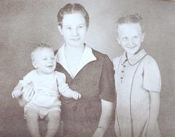
Ethel Leona Moser Payne
| Birth | : | 13 Oct 1896 Missouri, USA |
| Death | : | 27 Jan 1971 El Dorado, Butler County, Kansas, USA |
| Burial | : | St. John the Divine Churchyard, Acklington, Northumberland Unitary Authority, England |
| Coordinate | : | 55.3106000, -1.6435000 |
| Plot | : | Section: G Lot: 207 Space: 1 |
frequently asked questions (FAQ):
-
Where is Ethel Leona Moser Payne's memorial?
Ethel Leona Moser Payne's memorial is located at: St. John the Divine Churchyard, Acklington, Northumberland Unitary Authority, England.
-
When did Ethel Leona Moser Payne death?
Ethel Leona Moser Payne death on 27 Jan 1971 in El Dorado, Butler County, Kansas, USA
-
Where are the coordinates of the Ethel Leona Moser Payne's memorial?
Latitude: 55.3106000
Longitude: -1.6435000
Family Members:
Spouse
Children
Flowers:
Nearby Cemetories:
1. St. John the Divine Churchyard
Acklington, Northumberland Unitary Authority, England
Coordinate: 55.3106000, -1.6435000
2. Chevington Cemetery
Alnwick, Northumberland Unitary Authority, England
Coordinate: 55.2905270, -1.6148670
3. Amble West Cemetery
Amble, Northumberland Unitary Authority, England
Coordinate: 55.3311820, -1.5922950
4. Felton Cemetery
Felton, Northumberland Unitary Authority, England
Coordinate: 55.3020920, -1.7118410
5. Amble East Cemetery
Amble, Northumberland Unitary Authority, England
Coordinate: 55.3333190, -1.5696400
6. St John The Baptist Churchyard
Alnmouth, Northumberland Unitary Authority, England
Coordinate: 55.3882090, -1.6124020
7. St Mary the Virgin Churchyard
Longframlington, Northumberland Unitary Authority, England
Coordinate: 55.3028950, -1.7952920
8. Longframlington Church Cemetery Extension
Longframlington, Northumberland Unitary Authority, England
Coordinate: 55.3014700, -1.7950600
9. Alnmouth Cemetery
Alnmouth, Northumberland Unitary Authority, England
Coordinate: 55.3951400, -1.6064100
10. St. Mary The Virgin Churchyard
Lesbury, Northumberland Unitary Authority, England
Coordinate: 55.3986820, -1.6277570
11. Longframlington Cemetery
Longframlington, Northumberland Unitary Authority, England
Coordinate: 55.3085440, -1.8003926
12. Saint Helen’s Churchyard
Longhorsley, Northumberland Unitary Authority, England
Coordinate: 55.2432500, -1.7588200
13. Saint Bartholomew’s Churchyard
Cresswell, Northumberland Unitary Authority, England
Coordinate: 55.2331200, -1.5444900
14. Alnwick Cemetery
Alnwick, Northumberland Unitary Authority, England
Coordinate: 55.4037170, -1.6919940
15. Brinkburn Priory
Brinkburn, Northumberland Unitary Authority, England
Coordinate: 55.2788120, -1.8191170
16. Brinkburn Priory and Manor House
Longframlington, Northumberland Unitary Authority, England
Coordinate: 55.2789620, -1.8194090
17. St Cuthbert Churchyard
Hebron, Northumberland Unitary Authority, England
Coordinate: 55.2023450, -1.6963700
18. Saint Michael's Churchyard
Alnwick, Northumberland Unitary Authority, England
Coordinate: 55.4169400, -1.7111000
19. Saint John's Churchyard
Longhirst, Northumberland Unitary Authority, England
Coordinate: 55.1936200, -1.6474840
20. Alnwick Abbey
Alnwick, Northumberland Unitary Authority, England
Coordinate: 55.4198500, -1.7191400
21. St Peter's & St Paul's Churchyard
Longhoughton, Northumberland Unitary Authority, England
Coordinate: 55.4289930, -1.6169950
22. St John the Baptist Churchyard
Edlingham, Northumberland Unitary Authority, England
Coordinate: 55.3758250, -1.8212200
23. Lynemouth Cemetery
Lynemouth, Northumberland Unitary Authority, England
Coordinate: 55.2031759, -1.5361996
24. Fairmoor Cemetery
Morpeth, Northumberland Unitary Authority, England
Coordinate: 55.1861980, -1.7163260

