
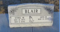
Ethel May Landreth Blair
| Birth | : | 16 May 1933 Sheridan County, Nebraska, USA |
| Death | : | 6 May 2016 Hay Springs, Sheridan County, Nebraska, USA |
| Burial | : | Gordon Cemetery, Gordon, Sheridan County, USA |
| Coordinate | : | 42.7858009, -102.2102966 |
| Description | : | Ethel May Landreth Blair May 16,1933-May 6,2016 Ethel May Landreth Blair, 83, of Clinton died, May 06,2016 at Pioneer Manor in Hay Springs. She was born May 16,1933 on the family farm north of Hay Springs to Alva and Eva (Polen) Landreth. She was the 8th of 10 children. The family moved to a farm north of Rushville where she grew up and attended country school through the 8th grade. Not having the opportunity to go to high school, she proudly earned her GED in 1980 with her sister Grace. In her younger years, she worked various food service jobs before she... Read More |
frequently asked questions (FAQ):
-
Where is Ethel May Landreth Blair's memorial?
Ethel May Landreth Blair's memorial is located at: Gordon Cemetery, Gordon, Sheridan County, USA.
-
When did Ethel May Landreth Blair death?
Ethel May Landreth Blair death on 6 May 2016 in Hay Springs, Sheridan County, Nebraska, USA
-
Where are the coordinates of the Ethel May Landreth Blair's memorial?
Latitude: 42.7858009
Longitude: -102.2102966
Family Members:
Parent
Spouse

Siblings

Flowers:


Nearby Cemetories:
1. Gordon Cemetery
Gordon, Sheridan County, USA
Coordinate: 42.7858009, -102.2102966
2. Mount Hope Cemetery
Gordon, Sheridan County, USA
Coordinate: 42.7113991, -102.2241974
3. Dane Cemetery
Cherry County, USA
Coordinate: 42.7924300, -102.0824700
4. Bethel Cemetery
Sheridan County, USA
Coordinate: 42.9011002, -102.3208008
5. Lavaca Cemetery
Irwin, Cherry County, USA
Coordinate: 42.7332993, -102.0175018
6. Amity Cemetery
Sheridan County, USA
Coordinate: 42.8036003, -102.4389038
7. Fair View Cemetery
Rushville, Sheridan County, USA
Coordinate: 42.7155991, -102.4325027
8. Saint Aloysius Cemetery
Sheridan County, USA
Coordinate: 42.9015500, -102.4025500
9. Saint Marys Cemetery
Rushville, Sheridan County, USA
Coordinate: 42.7174988, -102.4436035
10. Feather on Head Cemetery
Oglala Lakota County, USA
Coordinate: 43.0311012, -102.1611023
11. Holly Cemetery
Rushville, Sheridan County, USA
Coordinate: 42.8575120, -102.5370990
12. Novotny Cemetery
Hay Springs, Sheridan County, USA
Coordinate: 42.7742004, -102.5963974
13. Davis Cemetery
Rushville, Sheridan County, USA
Coordinate: 42.5421000, -102.4118800
14. Wolf Creek Community Cemetery
Oglala Lakota County, USA
Coordinate: 43.0405750, -102.3966490
15. Spotted Bear Family Cemetery
Denby, Oglala Lakota County, USA
Coordinate: 43.0608200, -102.3376600
16. Preble Cemetery
Sheridan County, USA
Coordinate: 42.6504000, -102.5765000
17. Abold Family Cemetery
Rushville, Sheridan County, USA
Coordinate: 42.8863500, -102.6158000
18. Bomar Cemetery
Hay Springs, Sheridan County, USA
Coordinate: 42.8062000, -102.6459600
19. Native American Cemetery
Oglala, Oglala Lakota County, USA
Coordinate: 43.0886002, -102.3550034
20. White Clay Cemetery
Rushville, Sheridan County, USA
Coordinate: 42.9732820, -102.5667230
21. Knight Cemetery
Oglala Lakota County, USA
Coordinate: 43.1039009, -102.1200027
22. Holy Cross Cemetery
Pine Ridge, Oglala Lakota County, USA
Coordinate: 43.0194016, -102.5503006
23. Pine Ridge Presbyterian Cemetery
Pine Ridge, Oglala Lakota County, USA
Coordinate: 43.0235200, -102.5506200
24. Beguin Cemetery
Sheridan County, USA
Coordinate: 42.5107994, -102.4982986