
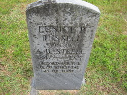
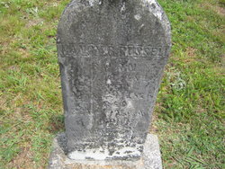
Eunice P. Russell Steele
| Birth | : | 1847 |
| Death | : | 31 Dec 1927 Thomasville, Davidson County, North Carolina, USA |
| Burial | : | Franklinville United Methodist Church Cemetery, Franklinville, Randolph County, USA |
| Coordinate | : | 35.7462900, -79.7037500 |
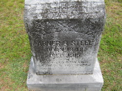
| Description | : | Father: Matthew W. Russell b: 18 SEP 1812 in Randolph County, North Carolina Mother: Eliza Louisa Cranford b: 29 JUL 1816 in North Carolina Marriage 1 Abner Branson Steele b: 1842 in Randolph County, North Carolina * Married: 31 DEC 1893 in Randolph County, North Carolina |
frequently asked questions (FAQ):
-
Where is Eunice P. Russell Steele's memorial?
Eunice P. Russell Steele's memorial is located at: Franklinville United Methodist Church Cemetery, Franklinville, Randolph County, USA.
-
When did Eunice P. Russell Steele death?
Eunice P. Russell Steele death on 31 Dec 1927 in Thomasville, Davidson County, North Carolina, USA
-
Where are the coordinates of the Eunice P. Russell Steele's memorial?
Latitude: 35.7462900
Longitude: -79.7037500
Family Members:
Parent
Spouse
Siblings

Flowers:


Nearby Cemetories:
1. Franklinville United Methodist Church Cemetery
Franklinville, Randolph County, USA
Coordinate: 35.7462900, -79.7037500
2. First Baptist Church Cemetery
Franklinville, Randolph County, USA
Coordinate: 35.7482230, -79.6908630
3. Billy Trogdon Cemetery
Asheboro, Randolph County, USA
Coordinate: 35.7392800, -79.7219100
4. Clear View Baptist Church Cemetery
Franklinville, Randolph County, USA
Coordinate: 35.7530800, -79.7234300
5. Old Salem Cemetery
Franklinville, Randolph County, USA
Coordinate: 35.7414017, -79.6742020
6. Cedar Falls United Methodist Church Cemetery
Asheboro, Randolph County, USA
Coordinate: 35.7472920, -79.7338990
7. Cedar Falls Baptist Church Cemetery
Cedar Falls, Randolph County, USA
Coordinate: 35.7480800, -79.7357800
8. Pleasant Cross Christian Church Cemetery
Asheboro, Randolph County, USA
Coordinate: 35.7254000, -79.7268740
9. Providence Baptist Church Cemetery
Asheboro, Randolph County, USA
Coordinate: 35.7231400, -79.7237930
10. Shady Grove Community Cemetery
Asheboro, Randolph County, USA
Coordinate: 35.7192180, -79.7287920
11. Ramseur Wesleyan Church Cemetery
Ramseur, Randolph County, USA
Coordinate: 35.7305670, -79.6593030
12. Sunset Knoll Cemetery
Ramseur, Randolph County, USA
Coordinate: 35.7313995, -79.6500015
13. Whites Memorial Baptist Church Cemetery
Franklinville, Randolph County, USA
Coordinate: 35.7939680, -79.7149760
14. Friendship AME Church Cemetery
Ramseur, Randolph County, USA
Coordinate: 35.7463280, -79.6437970
15. Patterson Grove Christian Church Cemetery
Ramseur, Randolph County, USA
Coordinate: 35.7743940, -79.6536550
16. Pleasant Ridge Christian Church Cemetery
Ramseur, Randolph County, USA
Coordinate: 35.7046860, -79.6670060
17. Odell Trogdon Cemetery
Grays Chapel, Randolph County, USA
Coordinate: 35.7947200, -79.7300200
18. Harmony Baptist Church Cemetery
Ramseur, Randolph County, USA
Coordinate: 35.7241680, -79.6418910
19. Giles Chapel United Methodist Church Cemetery
Asheboro, Randolph County, USA
Coordinate: 35.7462270, -79.7752450
20. Parks-Stout Cemetery
Randolph County, USA
Coordinate: 35.7205460, -79.6373740
21. Mount Tabor Community Church Cemetery
Asheboro, Randolph County, USA
Coordinate: 35.6892900, -79.7318400
22. Whites Chapel United Methodist Church Cemetery
Liberty, Randolph County, USA
Coordinate: 35.7850520, -79.6422990
23. Cool Springs Baptist Church Cemetery
Franklinville, Randolph County, USA
Coordinate: 35.8072420, -79.6805660
24. Faith Temple Baptist Church Cemetery
Franklinville, Randolph County, USA
Coordinate: 35.8023770, -79.7460950