
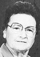

Evelyn Ann Miller Hoppe
| Birth | : | 30 Jan 1916 Colwich, Sedgwick County, Kansas, USA |
| Death | : | 27 Apr 2007 Sedgwick County, Kansas, USA |
| Burial | : | Watervale Cemetery, Clare, District Council of Clare and Gilbert Valleys, Australia |
| Coordinate | : | -33.9678890, 138.6546991 |
| Plot | : | Lot 47 |
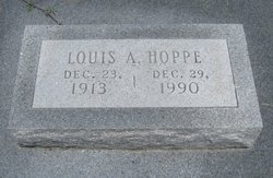
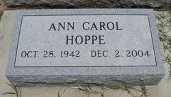
| Description | : | GODDARD - Hoppe, Evelyn A. (Miller), age 91, homemaker, died Friday, April 27, 2007. Visitation, 9am-4pm, Thurs, at Webb-Shinkle Mortuary, Clearwater. Rosary, 7pm, Thurs. Funeral Mass, 11am, Fri, both at St. John's Catholic Church, Clonmel. Preceded in death by husband, Lou Hoppe; daughter, Ann Carol Hoppe, sister, Delphine Bedessem; brother, Julius Miller. Survivors: sons and daughters-in-law, Gary and Marilyn Hoppe of Wichita, Gene and Carolann Hoppe of Independence, MO; daughter and son-in-law, Jane and Mark Thimesch of St. Joseph, MO; sister, Jean Ruppenthal of Leavenworth, KS; 10 grandchildren, 16 great-grandchildren, 1 great-great grandchild. Memorial: St. John's Catholic Church, 18630 W.... Read More |
frequently asked questions (FAQ):
-
Where is Evelyn Ann Miller Hoppe's memorial?
Evelyn Ann Miller Hoppe's memorial is located at: Watervale Cemetery, Clare, District Council of Clare and Gilbert Valleys, Australia.
-
When did Evelyn Ann Miller Hoppe death?
Evelyn Ann Miller Hoppe death on 27 Apr 2007 in Sedgwick County, Kansas, USA
-
Where are the coordinates of the Evelyn Ann Miller Hoppe's memorial?
Latitude: -33.9678890
Longitude: 138.6546991
Family Members:
Flowers:


Nearby Cemetories:
1. Watervale Cemetery
Clare, District Council of Clare and Gilbert Valleys, Australia
Coordinate: -33.9678890, 138.6546991
2. Leasingham Upper Skilly Cemetery
Auburn, District Council of Clare and Gilbert Valleys, Australia
Coordinate: -33.9996690, 138.6179280
3. St. Mark's Angelican Cemetery
Penwortham, District Council of Clare and Gilbert Valleys, Australia
Coordinate: -33.9214510, 138.6413830
4. St John’s Anglican Cemetery
Auburn, District Council of Clare and Gilbert Valleys, Australia
Coordinate: -34.0264310, 138.6835587
5. Mintaro Cemetery
Mintaro, District Council of Clare and Gilbert Valleys, Australia
Coordinate: -33.9175520, 138.7164540
6. Auburn Cemetery
Auburn, District Council of Clare and Gilbert Valleys, Australia
Coordinate: -34.0314560, 138.7036850
7. Mintaro Catholic Cemetery
Mintaro, District Council of Clare and Gilbert Valleys, Australia
Coordinate: -33.9124530, 138.7194630
8. Sevenhill Cemetery
Sevenhill, District Council of Clare and Gilbert Valleys, Australia
Coordinate: -33.8861020, 138.6312260
9. Springfield Cemetery
Williamstown, Barossa Council, Australia
Coordinate: -34.0000000, 138.5500000
10. Clare Spring Farm Wesleyan Cemetery
Clare, District Council of Clare and Gilbert Valleys, Australia
Coordinate: -33.8630660, 138.6387190
11. Undalya St. Patrick's Catholic Cemetery
Undalya, District Council of Clare and Gilbert Valleys, Australia
Coordinate: -34.0756230, 138.6930860
12. Hoyleton Public Cemetery
Hoyleton, Wakefield Regional Council, Australia
Coordinate: -34.0482700, 138.5571510
13. Kybunga Cemetery
Hoyleton, Wakefield Regional Council, Australia
Coordinate: -33.9202100, 138.5197360
14. Clare General Cemetery
Clare, District Council of Clare and Gilbert Valleys, Australia
Coordinate: -33.8429900, 138.6016430
15. Manoora Catholic Cemetery
Manoora, District Council of Clare and Gilbert Valleys, Australia
Coordinate: -33.9911920, 138.8144040
16. St. Michael's Catholic Cemetery
Clare, District Council of Clare and Gilbert Valleys, Australia
Coordinate: -33.8363060, 138.6096630
17. Clare Presbyterian Cemetery
Clare, District Council of Clare and Gilbert Valleys, Australia
Coordinate: -33.8338460, 138.6156330
18. Manoora Public Cemetery
Manoora, District Council of Clare and Gilbert Valleys, Australia
Coordinate: -34.0127090, 138.8140030
19. St. Barnabas Anglican Cemetery
Clare, District Council of Clare and Gilbert Valleys, Australia
Coordinate: -33.8301000, 138.6127000
20. Woolshed Flat Wesleyan Cemetery
Rhynie, District Council of Clare and Gilbert Valleys, Australia
Coordinate: -34.1220610, 138.6575830
21. White Hut Gaelic Cemetery
Clare, District Council of Clare and Gilbert Valleys, Australia
Coordinate: -33.8040010, 138.6283890
22. White Hut Cemetery
Stanley Flat, District Council of Clare and Gilbert Valleys, Australia
Coordinate: -33.7971650, 138.6234010
23. Farrell Flat Cemetery
Farrell Flats, Goyder Regional Council, Australia
Coordinate: -33.8249685, 138.7857266
24. Stanley Flat Gaelic Cemetery
Clare, District Council of Clare and Gilbert Valleys, Australia
Coordinate: -33.7915580, 138.6066290