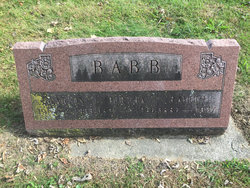
| Birth | : | 1 Jan 1875 Fulton County, Indiana, USA |
| Death | : | 11 Nov 1970 West Lafayette, Tippecanoe County, Indiana, USA |
| Burial | : | San Pierre Public Cemetery, San Pierre, Starke County, USA |
| Coordinate | : | 41.1997490, -86.8865814 |
| Inscription | : | FANNIE M. 1875 - 1970 |
| Description | : | MULBERRY - Mrs. Fannie E. Packer, 95, one of two remaining widows of Civil War veterans residing at the Indiana State Soldiers Home, died there at 8:25 PM Tuesday, Nov. 24, 1970, following an illness of several years. Mrs. Packer, a native of Loyal, lived at Mulberry for many years prior to moving to the Soldiers Home in 1958. She was married to John David Packer, who died in 1935. She was a member of Mulberry Lutheran Church. There are no immediate survivors. Burial will be at the San Pierre Cemetery, San Pierre, IN. --Lafayette Journal & Courier, Wed 11/25/1970 ∼Wife... Read More |
frequently asked questions (FAQ):
-
Where is Fannie E. Albin Packer's memorial?
Fannie E. Albin Packer's memorial is located at: San Pierre Public Cemetery, San Pierre, Starke County, USA.
-
When did Fannie E. Albin Packer death?
Fannie E. Albin Packer death on 11 Nov 1970 in West Lafayette, Tippecanoe County, Indiana, USA
-
Where are the coordinates of the Fannie E. Albin Packer's memorial?
Latitude: 41.1997490
Longitude: -86.8865814
Family Members:
Parent
Spouse
Siblings
Flowers:
Nearby Cemetories:
1. San Pierre Public Cemetery
San Pierre, Starke County, USA
Coordinate: 41.1997490, -86.8865814
2. All Saints Cemetery
San Pierre, Starke County, USA
Coordinate: 41.2034080, -86.8908580
3. Evangelical Association Church Cemetery
San Pierre, Starke County, USA
Coordinate: 41.2194500, -86.9155000
4. Saint Jacob Cemetery
North Judson, Starke County, USA
Coordinate: 41.2043343, -86.7954788
5. Bethlehem Cemetery
Pulaski County, USA
Coordinate: 41.1216810, -86.8617780
6. Noggle Cemetery
Medaryville, Pulaski County, USA
Coordinate: 41.1186030, -86.8912820
7. Pioneer Cemetery
North Judson, Starke County, USA
Coordinate: 41.2155037, -86.7778320
8. Saint John Cemetery
Medaryville, Pulaski County, USA
Coordinate: 41.1170998, -86.8667984
9. Goodway Baptist Church Cemetery
Medaryville, Pulaski County, USA
Coordinate: 41.1135840, -86.8739440
10. Kankakee Township Cemetery
Jasper County, USA
Coordinate: 41.1892430, -87.0032960
11. Highland Cemetery
North Judson, Starke County, USA
Coordinate: 41.2131004, -86.7574997
12. Oak Grove Cemetery
La Crosse, La Porte County, USA
Coordinate: 41.3130989, -86.9113998
13. Saint Marks Lutheran Cemetery
Medaryville, Pulaski County, USA
Coordinate: 41.0853004, -86.9028015
14. Sutton Cemetery
Medaryville, Pulaski County, USA
Coordinate: 41.0903015, -86.8383026
15. Saint Henrys Catholic Cemetery
Medaryville, Pulaski County, USA
Coordinate: 41.0849991, -86.9019012
16. Medaryville Cemetery
Medaryville, Pulaski County, USA
Coordinate: 41.0812149, -86.8831787
17. Wheatfield Cemetery
Wheatfield, Jasper County, USA
Coordinate: 41.1910019, -87.0462036
18. Sorrowful Mother Catholic Cemetery
Wheatfield, Jasper County, USA
Coordinate: 41.1918130, -87.0477340
19. Hershman Cemetery
Jasper County, USA
Coordinate: 41.1178017, -87.0074997
20. White Post Cemetery
Medaryville, Pulaski County, USA
Coordinate: 41.0713997, -86.8731995
21. Stump Family Burial Plot
Medaryville, Pulaski County, USA
Coordinate: 41.0658989, -86.9012451
22. Saint Paul Evangelical Lutheran Cemetery
Denham, Pulaski County, USA
Coordinate: 41.1531105, -86.7126083
23. Denham Cemetery
Denham, Pulaski County, USA
Coordinate: 41.1534590, -86.7120200
24. Independence Cemetery
Baileys Corner, Jasper County, USA
Coordinate: 41.0671997, -86.9496994


