
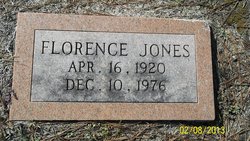

Florence Jones Fairey
| Birth | : | 16 Apr 1920 Colleton County, South Carolina, USA |
| Death | : | 10 Dec 1976 Orangeburg, Orangeburg County, South Carolina, USA |
| Burial | : | Taruheru Cemetery, Gisborne, Gisborne District, New Zealand |
| Coordinate | : | -38.6428900, 177.9802300 |
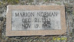
| Description | : | Branchville - Mrs. Florence Jones Fairey, 67, widow of Marion N. Fairey, died Friday at an Orangeburg hospital. The funeral will be 4 p.m. Saunday at Ott Funeral Chapel. Burial will be in Sardis Cemetery. Mrs. Fairey was born in Colleton County. She had lived at Branchville after moving from Smoaks 40 years ago and was a member of Branchville Baptist Church. Surviving are: a son, Norman L. Fairey of Sidell, La.; a daughter, Mrs. Marion F. Knight of Branchville; a brother, Blanco Stevens of Branchville; two sisters, Mrs. Clara M. Myers of Walterboro and Mrs. Aleen Pearson of Bamberg;... Read More |
frequently asked questions (FAQ):
-
Where is Florence Jones Fairey's memorial?
Florence Jones Fairey's memorial is located at: Taruheru Cemetery, Gisborne, Gisborne District, New Zealand.
-
When did Florence Jones Fairey death?
Florence Jones Fairey death on 10 Dec 1976 in Orangeburg, Orangeburg County, South Carolina, USA
-
Where are the coordinates of the Florence Jones Fairey's memorial?
Latitude: -38.6428900
Longitude: 177.9802300
Family Members:
Spouse
Children
Flowers:


Nearby Cemetories:
1. Taruheru Cemetery
Gisborne, Gisborne District, New Zealand
Coordinate: -38.6428900, 177.9802300
2. Makaraka Cemetery
Gisborne, Gisborne District, New Zealand
Coordinate: -38.6482600, 177.9803200
3. Waerenga a hika Urupā
Gisborne, Gisborne District, New Zealand
Coordinate: -38.5954100, 177.9263500
4. Opou Tuarakena Cemetery
Manutuke, Gisborne District, New Zealand
Coordinate: -38.6744759, 177.9095277
5. Opou Station Cemetery
Manutuke, Gisborne District, New Zealand
Coordinate: -38.6779310, 177.9084450
6. Paramanihi Waihirere Cemetery
Gisborne, Gisborne District, New Zealand
Coordinate: -38.5791250, 177.9488450
7. Manutuke Churchyard Urupā
Manutuke, Gisborne District, New Zealand
Coordinate: -38.6815360, 177.9080180
8. Patutahi Cemetery
Gisborne, Gisborne District, New Zealand
Coordinate: -38.6199300, 177.8955600
9. Manutuke Whakato Urupā
Manutuke, Gisborne District, New Zealand
Coordinate: -38.6843390, 177.9073690
10. Wainui
Gisborne District, New Zealand
Coordinate: -38.6950000, 178.0707400
11. Ormond Cemetery
Ormond, Gisborne District, New Zealand
Coordinate: -38.5526480, 177.9279330
12. Pouawa Urupā
Whangara, Gisborne District, New Zealand
Coordinate: -38.6085500, 178.1825900
13. Whangara Urupā
Whangara, Gisborne District, New Zealand
Coordinate: -38.5716800, 178.2310400
14. Tapuae o te Rangi Urupā
Whatatutu, Gisborne District, New Zealand
Coordinate: -38.3791200, 177.8134180
15. Kohimarama Urupā
Tolaga Bay, Gisborne District, New Zealand
Coordinate: -38.3791770, 178.3007610
16. Nuhaka North Cemetery
Morere, Wairoa District, New Zealand
Coordinate: -38.9797100, 177.7944300
17. Tolaga Bay Cemetery
Tolaga Bay, Gisborne District, New Zealand
Coordinate: -38.3643370, 178.3045240
18. Tolaga Bay Urupā
Tolaga Bay, Gisborne District, New Zealand
Coordinate: -38.3629400, 178.3050080
19. Rakauroa Cemetery
Matawai, Gisborne District, New Zealand
Coordinate: -38.4358900, 177.5711400
20. Okuri Marea Urupa
Tolaga Bay, Gisborne District, New Zealand
Coordinate: -38.3055250, 178.2704340
21. Arataiha Urupā
Nuhaka, Wairoa District, New Zealand
Coordinate: -39.0201020, 177.7361770
22. Opoutama Cemetery
Mahia, Wairoa District, New Zealand
Coordinate: -39.0550780, 177.8405420
23. Manawarakau Urupā
Nuhaka, Wairoa District, New Zealand
Coordinate: -39.0371870, 177.7262650
24. Kaiuku Marae Urupā
Mahia, Wairoa District, New Zealand
Coordinate: -39.0823112, 177.9086516