
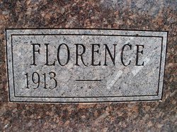
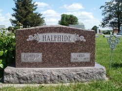
Florence Laura Colegrove Halfhide
| Birth | : | 24 Feb 1913 Kansas, USA |
| Death | : | 10 Dec 2005 Chadron, Dawes County, Nebraska, USA |
| Burial | : | Pawnee City Cemetery, Pawnee City, Pawnee County, USA |
| Coordinate | : | 40.1109009, -96.1608810 |
| Plot | : | Hazel Hill 6- 8- 8 |
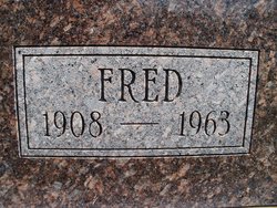
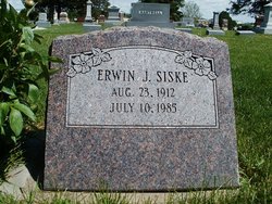
| Description | : | Daughter of Ray & Mary (Campbell) Colegrove. Married Feb.22, 1936 to Fred A. Halfhide. They lived in Pawnee City. Fred died in 1963 after 27 years of marriage. Florence remarried May 1965 to Erwin Siske, who died in 1985 after 20 years of marriage. Nov. 1986 she remarried to Harold Borland, who had also lost two spouses. Florence was a school teacher for much of her life, in Pawnee County rural schools and DuBois where she retired. Mother of Arthur & Nancy. (Pawnee Republican, May 18, 2006.) FLORENCE LAURA BORLAND Florence Laura Colgrove, daughter of Ray and Mary (Campbell) Colegrove was born on a farm in... Read More |
frequently asked questions (FAQ):
-
Where is Florence Laura Colegrove Halfhide's memorial?
Florence Laura Colegrove Halfhide's memorial is located at: Pawnee City Cemetery, Pawnee City, Pawnee County, USA.
-
When did Florence Laura Colegrove Halfhide death?
Florence Laura Colegrove Halfhide death on 10 Dec 2005 in Chadron, Dawes County, Nebraska, USA
-
Where are the coordinates of the Florence Laura Colegrove Halfhide's memorial?
Latitude: 40.1109009
Longitude: -96.1608810
Family Members:
Parent

Spouse
Flowers:


Nearby Cemetories:
1. Pawnee City Cemetery
Pawnee City, Pawnee County, USA
Coordinate: 40.1109009, -96.1608810
2. East Amish Cemetery
Table Rock, Pawnee County, USA
Coordinate: 40.1310000, -96.0854000
3. Evergreen Cemetery
Pawnee County, USA
Coordinate: 40.0485992, -96.1417007
4. Pleasant Valley Cemetery
Pawnee County, USA
Coordinate: 40.0299988, -96.1554794
5. Table Rock Cemetery
Table Rock, Pawnee County, USA
Coordinate: 40.1791400, -96.1037400
6. Prairie Star Pioneer Cemetery
Du Bois, Pawnee County, USA
Coordinate: 40.0293000, -96.1041000
7. Beranek Cemetery
Table Rock, Pawnee County, USA
Coordinate: 40.2042007, -96.1607971
8. Pleasant Ridge Cemetery
Du Bois, Pawnee County, USA
Coordinate: 40.0156000, -96.1494000
9. West Branch Cemetery
Pawnee County, USA
Coordinate: 40.0787940, -96.2797160
10. Saint Anthonys Cemetery
Steinauer, Pawnee County, USA
Coordinate: 40.2075005, -96.2189026
11. Johnson Creek Cemetery
Pawnee City, Pawnee County, USA
Coordinate: 40.0270000, -96.2465000
12. Clear Creek Cemetery
Table Rock, Pawnee County, USA
Coordinate: 40.2193985, -96.1391983
13. Bohemian Cemetery
Table Rock, Pawnee County, USA
Coordinate: 40.1786003, -96.0374985
14. Saint Peters Evangelican Cemetery
Du Bois, Pawnee County, USA
Coordinate: 40.0010000, -96.1095000
15. Dry Branch Pioneer Cemetery
Richardson County, USA
Coordinate: 40.1292000, -96.0100021
16. DuBois Cemetery
Du Bois, Pawnee County, USA
Coordinate: 40.0231018, -96.0488968
17. Bohemian Cemetery
Richardson County, USA
Coordinate: 40.1175003, -95.9955978
18. Saint Johns Cemetery
Table Rock, Pawnee County, USA
Coordinate: 40.2148000, -96.0657000
19. Salems Cemetery
Steinauer, Pawnee County, USA
Coordinate: 40.2166000, -96.2555000
20. McCaffrey Cemetery
Nemaha County, USA
Coordinate: 39.9827100, -96.1474500
21. Madden Cemetery
Axtell, Marshall County, USA
Coordinate: 39.9866800, -96.2490300
22. Friedens United Church of Christ Cemetery
Bern, Nemaha County, USA
Coordinate: 39.9929008, -96.0529480
23. Saint Peters Lutheran Church Cemetery
Steinauer, Pawnee County, USA
Coordinate: 40.2555000, -96.1801000
24. Cincinnati Cemetery
Du Bois, Pawnee County, USA
Coordinate: 40.0042000, -96.0274963