
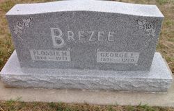
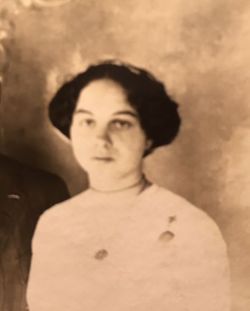

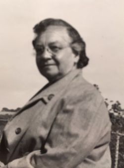

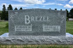
Flossie Maude Johnson Brezee
| Birth | : | 29 Apr 1892 Altamont, Deuel County, South Dakota, USA |
| Death | : | 27 Jun 1971 Clear Lake, Deuel County, South Dakota, USA |
| Burial | : | St. Mary's Churchyard, Horton, Northumberland Unitary Authority, England |
| Coordinate | : | 55.1106200, -1.5706200 |
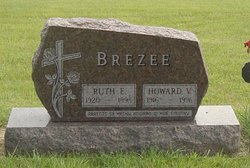
| Description | : | Flossie Maude Johnson was born on the family farm in Glenwood township which was close to the small town of Clear Lake, South Dakota. Flossie M. Johnson married Louis Edward Brezee on March 13, 1912 in Clear Lake, South Dakota. He died in Holyoke, Philips County, Colorado in 1921 leaving his 5 year old son, Howard Vernon Brezee and his young wife. Their daughter was born a few months after his untimely death. Flossie M. Johnson-Brezee married a second time to George Lymann Brezee who was a brother to her first husband, He died in Clear Lake,... Read More |
frequently asked questions (FAQ):
-
Where is Flossie Maude Johnson Brezee's memorial?
Flossie Maude Johnson Brezee's memorial is located at: St. Mary's Churchyard, Horton, Northumberland Unitary Authority, England.
-
When did Flossie Maude Johnson Brezee death?
Flossie Maude Johnson Brezee death on 27 Jun 1971 in Clear Lake, Deuel County, South Dakota, USA
-
Where are the coordinates of the Flossie Maude Johnson Brezee's memorial?
Latitude: 55.1106200
Longitude: -1.5706200
Family Members:
Parent

Spouse
Siblings
Children
Flowers:


Nearby Cemetories:
1. St. Mary's Churchyard
Horton, Northumberland Unitary Authority, England
Coordinate: 55.1106200, -1.5706200
2. St. Cuthbert Churchyard
Bedlington, Northumberland Unitary Authority, England
Coordinate: 55.1303910, -1.5928880
3. St. Nicholas' Churchyard
Cramlington, Northumberland Unitary Authority, England
Coordinate: 55.0856460, -1.5834930
4. Mayfield Cemetery
Cramlington, Northumberland Unitary Authority, England
Coordinate: 55.0837139, -1.5730931
5. Cowpen Roman Catholic Burial Ground
Blyth, Northumberland Unitary Authority, England
Coordinate: 55.1305300, -1.5386300
6. Cowpen Cemetery and Crematorium
Blyth, Northumberland Unitary Authority, England
Coordinate: 55.1311260, -1.5294460
7. Netherton Lane Cemetery
Bedlington, Northumberland Unitary Authority, England
Coordinate: 55.1318960, -1.6106800
8. Blyth Links Cemetery
Blyth, Northumberland Unitary Authority, England
Coordinate: 55.1053800, -1.4997200
9. Saint Cuthbert's Churchyard
Blyth, Northumberland Unitary Authority, England
Coordinate: 55.1265800, -1.5031400
10. St. Paul's Churchyard
Choppington, Northumberland Unitary Authority, England
Coordinate: 55.1494290, -1.6009780
11. St. John's Churchyard
Annitsford, Metropolitan Borough of North Tyneside, England
Coordinate: 55.0676900, -1.5785500
12. St. John the Baptist Catholic Churchyard
Cramlington, Northumberland Unitary Authority, England
Coordinate: 55.0675480, -1.5783300
13. St Peter Churchyard
Cambois, Northumberland Unitary Authority, England
Coordinate: 55.1615300, -1.5604100
14. North Seaton Cemetery
Ashington, Northumberland Unitary Authority, England
Coordinate: 55.1669770, -1.5575500
15. Dudley Cemetery
Dudley, Metropolitan Borough of North Tyneside, England
Coordinate: 55.0566100, -1.6143420
16. St Andrew's Churchyard
Bothal, Northumberland Unitary Authority, England
Coordinate: 55.1731340, -1.6205890
17. Saint Aidens Churchyard
Ashington, Northumberland Unitary Authority, England
Coordinate: 55.1826900, -1.5781400
18. Earsdon Cemetery
Earsdon, Metropolitan Borough of North Tyneside, England
Coordinate: 55.0474600, -1.5007200
19. North Gosforth Cemetery
Gosforth, Metropolitan Borough of Newcastle upon Tyne, England
Coordinate: 55.0407400, -1.6220700
20. St. Alban’s Churchyard
Earsdon, Metropolitan Borough of North Tyneside, England
Coordinate: 55.0461000, -1.5004000
21. Hazelrigg
Newcastle-upon-Tyne, Metropolitan Borough of Newcastle upon Tyne, England
Coordinate: 55.0410640, -1.6249120
22. Whitley Bay Cemetery and Crematorium
Whitley Bay, Metropolitan Borough of North Tyneside, England
Coordinate: 55.0636970, -1.4588430
23. St. Matthew's Churchyard
Dinnington, Metropolitan Borough of Newcastle upon Tyne, England
Coordinate: 55.0533400, -1.6761000
24. St. Mary the Virgin Church
Morpeth, Northumberland Unitary Authority, England
Coordinate: 55.1598990, -1.6917760