
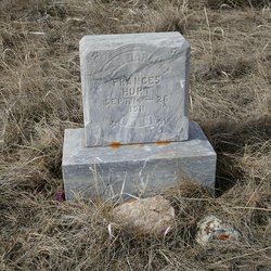
Frances Lillian Hurt
| Birth | : | 14 Sep 1911 Galata, Toole County, Montana, USA |
| Death | : | 26 Sep 1911 Toole County, Montana, USA |
| Burial | : | Grandview Cemetery, Toole County, USA |
| Coordinate | : | 48.7265000, -111.3615000 |
| Description | : | Daughter of Earl Othello Hurt and Laura Therese Bachman. |
frequently asked questions (FAQ):
-
Where is Frances Lillian Hurt's memorial?
Frances Lillian Hurt's memorial is located at: Grandview Cemetery, Toole County, USA.
-
When did Frances Lillian Hurt death?
Frances Lillian Hurt death on 26 Sep 1911 in Toole County, Montana, USA
-
Where are the coordinates of the Frances Lillian Hurt's memorial?
Latitude: 48.7265000
Longitude: -111.3615000
Family Members:
Parent
Siblings


Nearby Cemetories:
1. Grandview Cemetery
Toole County, USA
Coordinate: 48.7265000, -111.3615000
2. Trinity Church Cemetery
Lothair, Liberty County, USA
Coordinate: 48.7263000, -111.2296000
3. Eagle Creek Colony Cemetery
Chester, Liberty County, USA
Coordinate: 48.6976000, -111.2011000
4. Gold Butte Cemetery
Toole County, USA
Coordinate: 48.8793983, -111.3966980
5. Old Indian Cemetery
Liberty County, USA
Coordinate: 48.8680992, -111.2585983
6. Whitlash Cemetery
Liberty County, USA
Coordinate: 48.9085999, -111.2699966
7. Galata Cemetery
Toole County, USA
Coordinate: 48.4655991, -111.3349991
8. Devon Cemetery
Toole County, USA
Coordinate: 48.4693000, -111.4713000
9. Lothair Catholic Cemetery
Lothair, Liberty County, USA
Coordinate: 48.4687000, -111.2484000
10. Lothair Protestant Cemetery
Lothair, Liberty County, USA
Coordinate: 48.4694000, -111.2393100
11. Nutter Ranch Cemetery
Sunburst, Toole County, USA
Coordinate: 48.9668200, -111.6365320
12. Sunnyside Cemetery
Aden, Medicine Hat Census Division, Canada
Coordinate: 49.0286300, -111.3240800
13. Dunkirk Cemetery
Dunkirk, Toole County, USA
Coordinate: 48.4797810, -111.6761860
14. Chester Cemetery
Chester, Liberty County, USA
Coordinate: 48.5219002, -110.9807968
15. Sage Creek Colony Cemetery
Sage Creek Colony, Liberty County, USA
Coordinate: 48.9271000, -110.9735000
16. Sunburst Cemetery
Sunburst, Toole County, USA
Coordinate: 48.8847800, -111.8743800
17. Mountain View Cemetery
Shelby, Toole County, USA
Coordinate: 48.5032200, -111.8675800
18. Valley View Cemetery
Shelby, Toole County, USA
Coordinate: 48.5190000, -111.8863000
19. Joplin Cemetery
Joplin, Liberty County, USA
Coordinate: 48.5576720, -110.7622930
20. Omholt Cemetery
Toole County, USA
Coordinate: 48.3058014, -111.5346985
21. Masinasin Cemetery
Milk River, Lethbridge Census Division, Canada
Coordinate: 49.1302328, -111.6527199
22. Camrose Colony Cemetery
Conrad, Pondera County, USA
Coordinate: 48.3092000, -111.6114000
23. Bethel Cemetery
Hill County, USA
Coordinate: 48.6685982, -110.6406021
24. Saint Olaf Lutheran Cemetery
Toole County, USA
Coordinate: 48.2479000, -111.3182000