
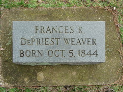
Frances Rebecca DePriest Weaver
| Birth | : | 5 Oct 1844 Oregon County, Missouri, USA |
| Death | : | 1864 Shannon County, Missouri, USA |
| Burial | : | Hawkshaw Methodist Church Cemetery, Hawkshaw, Metropolitan Borough of Bury, England |
| Coordinate | : | 53.6313490, -2.3674190 |
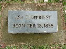
| Description | : | "FRANCES REBEKAH DePRIEST, born Oct 5, 1844, MO; married James Weaver; d about 1864 (she reached over a fence to pick up corn cobs for kindling before her baby was born, ruptured a blood vessel and hemorrhaged to death; she was 20 years old);bur. DePriest-Brown Cemetery." Contributor: Ronald Sommers. ************************************************************** Frances B Depriest in the 1850 United States Federal Census Name: Frances B Depriest Gender: Female Age: 6 Birth Year: abt 1844 Birthplace: Missouri Home in 1850: District 65, Oregon, Missouri, USA Attended School: Y Line Number: 28 Dwelling Number: 11 Family Number: 11 Household Members Age Isaac C Depriest... Read More |
frequently asked questions (FAQ):
-
Where is Frances Rebecca DePriest Weaver's memorial?
Frances Rebecca DePriest Weaver's memorial is located at: Hawkshaw Methodist Church Cemetery, Hawkshaw, Metropolitan Borough of Bury, England.
-
When did Frances Rebecca DePriest Weaver death?
Frances Rebecca DePriest Weaver death on 1864 in Shannon County, Missouri, USA
-
Where are the coordinates of the Frances Rebecca DePriest Weaver's memorial?
Latitude: 53.6313490
Longitude: -2.3674190
Family Members:
Parent
Spouse
Siblings


Nearby Cemetories:
1. Hawkshaw Methodist Church Cemetery
Hawkshaw, Metropolitan Borough of Bury, England
Coordinate: 53.6313490, -2.3674190
2. St Mary Churchyard
Hawkshaw, Metropolitan Borough of Bury, England
Coordinate: 53.6307270, -2.3636210
3. Congregational Churchyard
Affetside, Metropolitan Borough of Bury, England
Coordinate: 53.6175200, -2.3705800
4. Greenmount United Reformed Churchyard
Greenmount, Metropolitan Borough of Bury, England
Coordinate: 53.6254581, -2.3381465
5. Methodist Church Churchyard
Edgworth, Blackburn with Darwen Unitary Authority, England
Coordinate: 53.6424280, -2.3962830
6. St Anne Churchyard
Tottington, Metropolitan Borough of Bury, England
Coordinate: 53.6161499, -2.3409030
7. St. Anne's Churchyard
Chapeltown, Blackburn with Darwen Unitary Authority, England
Coordinate: 53.6371710, -2.4030440
8. St. John's Churchyard
Tottington, Metropolitan Borough of Bury, England
Coordinate: 53.6141180, -2.3400670
9. Edgworth Congregational Chapelyard
Edgworth, Blackburn with Darwen Unitary Authority, England
Coordinate: 53.6476280, -2.3967210
10. Ramsbottom Cemetery
Ramsbottom, Metropolitan Borough of Bury, England
Coordinate: 53.6372986, -2.3271000
11. Emmanuel Churchyard
Holcombe, Metropolitan Borough of Bury, England
Coordinate: 53.6463000, -2.3293400
12. Tottington Road Methodist Church Churchyard
Harwood, Metropolitan Borough of Bolton, England
Coordinate: 53.6079190, -2.3904960
13. Harwood Methodist Church Cemetery
Harwood, Metropolitan Borough of Bolton, England
Coordinate: 53.6028240, -2.3903990
14. St. Maxentius Churchyard
Bradshaw, Metropolitan Borough of Bolton, England
Coordinate: 53.6056800, -2.4014800
15. Rowlands Methodist Churchyard
Summerseat, Metropolitan Borough of Bury, England
Coordinate: 53.6294360, -2.3102920
16. Christ Church Churchyard
Harwood, Metropolitan Borough of Bolton, England
Coordinate: 53.5948860, -2.3821990
17. St. James Churchyard
Bury, Metropolitan Borough of Bury, England
Coordinate: 53.5996770, -2.3214600
18. Christ Church Churchyard
Egerton, Metropolitan Borough of Bolton, England
Coordinate: 53.6237080, -2.4389210
19. Ainsworth Unitarian Chapel Cemetery
Metropolitan Borough of Bury, England
Coordinate: 53.5882700, -2.3590390
20. Ainsworth Methodist Churchyard
Ainsworth, Metropolitan Borough of Bury, England
Coordinate: 53.5877390, -2.3623810
21. Christ Church Churchyard
Walmersley, Metropolitan Borough of Bury, England
Coordinate: 53.6193360, -2.2964630
22. Park Chapel
Walmersley, Metropolitan Borough of Bury, England
Coordinate: 53.6205060, -2.2958590
23. Christ Church Churchyard
Bury, Metropolitan Borough of Bury, England
Coordinate: 53.6194570, -2.2960140
24. Christ Church Churchyard
Ainsworth, Metropolitan Borough of Bury, England
Coordinate: 53.5875690, -2.3589540