
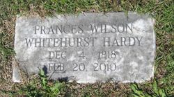

Frances Wilson Whitehurst Hardy
| Birth | : | 4 Dec 1918 Bethel, Pitt County, North Carolina, USA |
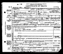
| Death | : | 20 Feb 2010 Tarboro, Edgecombe County, North Carolina, USA |
| Burial | : | Cranstoun Parish Churchyard, Scotland |
| Coordinate | : | 55.8792400, -2.9860300 |
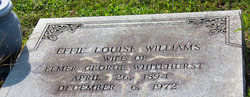
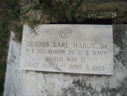
| Description | : | The third of six children born to the late Elmer George and Effie Williams Whitehurst, she was the widow of Dennis Earl Hardy, Sr. (married on November 1, 1936. She was a member of the Bethel United Methodist Church. In addition to her parents and husband, she was preceded in death by a son, Dennis Earl Hardy, Jr. She was survived by her daughter, Shirley Hardy Herald Harris (Edward); grandchildren, Gregory Herald, Ashley Herald Whitley, Parker Hardy and Jamie Hardy Stankowsky; sister, Dorothy Whitehurst Manning; and an extended family of relatives including great-grandchildren and great-great-grandchildren. Her... Read More |
frequently asked questions (FAQ):
-
Where is Frances Wilson Whitehurst Hardy's memorial?
Frances Wilson Whitehurst Hardy's memorial is located at: Cranstoun Parish Churchyard, Scotland.
-
When did Frances Wilson Whitehurst Hardy death?
Frances Wilson Whitehurst Hardy death on 20 Feb 2010 in Tarboro, Edgecombe County, North Carolina, USA
-
Where are the coordinates of the Frances Wilson Whitehurst Hardy's memorial?
Latitude: 55.8792400
Longitude: -2.9860300
Family Members:
Parent
Spouse
Siblings
Flowers:


Nearby Cemetories:
1. Cranstoun Parish Churchyard
Scotland
Coordinate: 55.8792400, -2.9860300
2. Penicuik Old Churchyard
Scotland
Coordinate: 55.8270580, -3.2193700
3. Athelstaneford Parish Church Cemetery
Scotland
Coordinate: 55.9867390, -2.7499130
4. Longformacus Parish Church
Scotland
Coordinate: 55.8080300, -2.4898700
5. Ecclesmachan Cemetery
Scotland
Coordinate: 55.9461400, -3.5096500
6. Largo Cemetery
Scotland
Coordinate: 56.2230510, -2.9332210
7. Abercrombie Old Chapelyard
Scotland
Coordinate: 56.2210500, -2.7725053
8. St. Serf's Priory
Scotland
Coordinate: 56.1876160, -3.3529760
9. Muiravonside Church of Scotland
Scotland
Coordinate: 55.9743440, -3.6742900
10. Cults Cemetery
Scotland
Coordinate: 56.2767906, -3.0565600
11. Chapel Knowe and Cockburn's Tombe
Scotland
Coordinate: 55.4942625, -3.2214799
12. St Cuthbert Churchyard
Carham, Northumberland Unitary Authority, England
Coordinate: 55.6389230, -2.3238090
13. Abdie Churchyard
Scotland
Coordinate: 56.3338200, -3.1993100
14. St Helen's Churchyard
Cornhill-on-Tweed, Northumberland Unitary Authority, England
Coordinate: 55.6464840, -2.2264990
15. Creich Cemetery
Scotland
Coordinate: 56.3798110, -3.0912140
16. Mindrum Churchyard
Mindrum, Northumberland Unitary Authority, England
Coordinate: 55.5937100, -2.2481000
17. Flodden Field Cemetery
Branxton, Northumberland Unitary Authority, England
Coordinate: 55.6287730, -2.1765120
18. St Paul's Churchyard
Branxton, Northumberland Unitary Authority, England
Coordinate: 55.6308820, -2.1726490
19. Tullibody Old Kirkyard
Scotland
Coordinate: 56.1371705, -3.8353321
20. Tullibody Cemetery
Scotland
Coordinate: 56.1375500, -3.8356500
21. All Saints Churchyard
Duddo, Northumberland Unitary Authority, England
Coordinate: 55.6859800, -2.0862900
22. St. Mary the Virgin Chapelyard
Etal, Northumberland Unitary Authority, England
Coordinate: 55.6481100, -2.1150200
23. Berwick-upon-Tweed Cemetery
Berwick-upon-Tweed, Northumberland Unitary Authority, England
Coordinate: 55.7799800, -2.0107500
24. St Michael and All Angels Churchyard
Ford, Northumberland Unitary Authority, England
Coordinate: 55.6301700, -2.0895430