
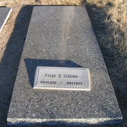
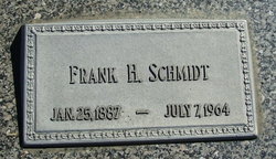
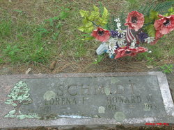
Frank Herman Schmidt
| Birth | : | 25 Jan 1887 Lancaster County, Nebraska, USA |
| Death | : | 7 Jul 1964 |
| Burial | : | Lakeside Cemetery, Port Huron, St. Clair County, USA |
| Coordinate | : | 43.0191994, -82.4357986 |
| Plot | : | NW 200 |
| Description | : | Frank H. Schmidt, longtime farmer of Webster County, died unexpectedly Tuesday, July 7, 1964 at his home at 5 o'clock p.m. at the age of 77 years, 5 months and 13 days. He was born at Hickman, Nebr., and moved to Blue Hill with his parents at the age of 2 and spent his entire life in this community. He was actively engaged in farming until he passed away. He served on the Farmer's Cooperative Elevator Board of Directors for 40 years. He was a charter member of this association. In 1908 he was united in... Read More |
frequently asked questions (FAQ):
-
Where is Frank Herman Schmidt's memorial?
Frank Herman Schmidt's memorial is located at: Lakeside Cemetery, Port Huron, St. Clair County, USA.
-
When did Frank Herman Schmidt death?
Frank Herman Schmidt death on 7 Jul 1964 in
-
Where are the coordinates of the Frank Herman Schmidt's memorial?
Latitude: 43.0191994
Longitude: -82.4357986
Family Members:
Parent

Spouse
Siblings

Children
Flowers:


Nearby Cemetories:
1. Mount Sinai Cemetery
Port Huron, St. Clair County, USA
Coordinate: 43.0167007, -82.4328003
2. Mount Hope Cemetery
Port Huron, St. Clair County, USA
Coordinate: 43.0236015, -82.4385986
3. Allied Veterans Memorial Cemetery
Port Huron, St. Clair County, USA
Coordinate: 43.0248985, -82.4359970
4. Lakeview Cemetery
Sarnia, Lambton County, Canada
Coordinate: 42.9965520, -82.3875890
5. Our Lady of Mercy Cemetery
Sarnia, Lambton County, Canada
Coordinate: 42.9982452, -82.3846283
6. Sunset Memorial Gardens Cemetery
Fort Gratiot Township, St. Clair County, USA
Coordinate: 43.0384540, -82.4893960
7. Lakeshore Presbyterian Columbarium
Fort Gratiot Township, St. Clair County, USA
Coordinate: 43.0608610, -82.4612930
8. Harrington Cemetery
Port Huron Township, St. Clair County, USA
Coordinate: 43.0030840, -82.4949480
9. Our Saviour Lutheran Church Columbarium
Port Huron, St. Clair County, USA
Coordinate: 42.9727670, -82.4263990
10. First Congregational Church Columbarium
Port Huron, St. Clair County, USA
Coordinate: 42.9717420, -82.4278690
11. Grace Episcopal Church Columbarium
Port Huron, St. Clair County, USA
Coordinate: 42.9715990, -82.4260910
12. Woodland Cemetery
Port Huron, St. Clair County, USA
Coordinate: 42.9820000, -82.4790000
13. Blackwell United Church Cemetery
Sarnia, Lambton County, Canada
Coordinate: 43.0209550, -82.3172070
14. Kinney Cemetery
Wadhams, St. Clair County, USA
Coordinate: 43.0018997, -82.5535965
15. Aamjiwnaang First Nations Cemetery
Sarnia, Lambton County, Canada
Coordinate: 42.9311600, -82.4330200
16. Resurrection Cemetery
Sarnia, Lambton County, Canada
Coordinate: 42.9821701, -82.3155746
17. Lakeport Cemetery
Burtchville Township, St. Clair County, USA
Coordinate: 43.1148872, -82.4949417
18. Froomfield Early Settlers Cemetery
Froomfield, Lambton County, Canada
Coordinate: 42.9093900, -82.4536400
19. Froomfield United Cemetery
Froomfield, Lambton County, Canada
Coordinate: 42.9093700, -82.4534440
20. Kimball Township Cemetery
Kimball, St. Clair County, USA
Coordinate: 42.9480360, -82.5624700
21. Ruby Cemetery
Ruby, St. Clair County, USA
Coordinate: 43.0377998, -82.5988998
22. Smith Blackstock Road Cemetery
Kimball, St. Clair County, USA
Coordinate: 42.9058930, -82.5096090
23. Irwin Cemetery
Bunyan, Lambton County, Canada
Coordinate: 42.9586500, -82.2820100
24. Saint Marys Cemetery
Marysville, St. Clair County, USA
Coordinate: 42.9028015, -82.5113983