
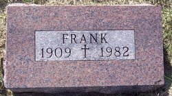

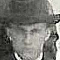
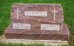
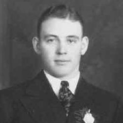
Frank Steffes
| Birth | : | 16 Jun 1909 Carroll County, Iowa, USA |
| Death | : | 9 Apr 1982 Carroll, Carroll County, Iowa, USA |
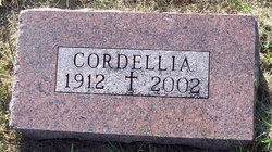
| Burial | : | Sacred Heart Cemetery, Templeton, Carroll County, USA |
| Coordinate | : | 41.9138746, -94.9460994 |
| Description | : | Frank was the son of Henry Steffes and Kate Rupiper. April 12, 1982 - Carroll Daily Times - TEMPLETON — Frank Steffes, 72, a semi-retired farmer, died Friday, April 9, at St. Anthony Regional Hospital in Carroll after a brief illness. He had been a county assessor for Eden and Ewoldt Townships for many years. Rite of the Christian Burial was celebrated at 12:30 p.m. Monday, April 12, at Sacred Heart Church in Templeton with the Rev. Eugene Schumacher officiating. Burial was in the parish cemetery. Serving as active pallbearers were Bruce Steffes, Jerry Fischer, Rick Frazier, Joey Steffes, Kent Steffes,... Read More |
frequently asked questions (FAQ):
-
Where is Frank Steffes's memorial?
Frank Steffes's memorial is located at: Sacred Heart Cemetery, Templeton, Carroll County, USA.
-
When did Frank Steffes death?
Frank Steffes death on 9 Apr 1982 in Carroll, Carroll County, Iowa, USA
-
Where are the coordinates of the Frank Steffes's memorial?
Latitude: 41.9138746
Longitude: -94.9460994
Family Members:
Parent
Spouse
Siblings

Children
Flowers:


Nearby Cemetories:
1. Sacred Heart Cemetery
Templeton, Carroll County, USA
Coordinate: 41.9138746, -94.9460994
2. Elba Cemetery
Templeton, Carroll County, USA
Coordinate: 41.9068985, -94.9131012
3. Sacred Heart Cemetery
Manning, Carroll County, USA
Coordinate: 41.9132500, -95.0540000
4. Gray Cemetery
Gray, Audubon County, USA
Coordinate: 41.8414001, -94.9946976
5. Manning Cemetery
Manning, Carroll County, USA
Coordinate: 41.8990000, -95.0620000
6. Holy Angels Cemetery
Carroll County, USA
Coordinate: 42.0014000, -94.9141998
7. Cameron Cemetery
Audubon County, USA
Coordinate: 41.8236008, -94.9167023
8. Dedham Cemetery
Dedham, Carroll County, USA
Coordinate: 41.8993988, -94.8225021
9. Saint Josephs Cemetery
Dedham, Carroll County, USA
Coordinate: 41.8993988, -94.8210983
10. Saint Augustine Cemetery
Halbur, Carroll County, USA
Coordinate: 42.0066986, -94.9744034
11. Lincoln Township Cemetery
Gray, Audubon County, USA
Coordinate: 41.8198130, -95.0154970
12. Saint Marys Catholic Cemetery
Willey, Carroll County, USA
Coordinate: 41.9783363, -94.8212204
13. Iowa Township Cemetery
Aspinwall, Crawford County, USA
Coordinate: 41.9216995, -95.1113968
14. McCurdy Cemetery
Carroll County, USA
Coordinate: 41.9403000, -94.7649994
15. Viola Center Cemetery
Viola Center, Audubon County, USA
Coordinate: 41.8236008, -94.8016968
16. Old Carrollton Cemetery
Carrollton, Carroll County, USA
Coordinate: 41.9233017, -94.7403030
17. Mount Olivet Cemetery
Carroll, Carroll County, USA
Coordinate: 42.0536340, -94.8595510
18. Carroll City Cemetery
Carroll, Carroll County, USA
Coordinate: 42.0560963, -94.8599856
19. Hayes Township Cemetery
Westside, Crawford County, USA
Coordinate: 42.0083199, -95.1216583
20. Luccocks Grove Cemetery
Audubon County, USA
Coordinate: 41.7619019, -94.8653030
21. Douglas Township Cemetery
Audubon County, USA
Coordinate: 41.7611008, -95.0282974
22. Oak Hill Cemetery
Coon Rapids, Carroll County, USA
Coordinate: 41.9053001, -94.7200012
23. Westside Cemetery
Westside, Crawford County, USA
Coordinate: 42.0602989, -95.0922012
24. Saint Francis Cemetery
Maple River, Carroll County, USA
Coordinate: 42.0969009, -94.9372025