| Birth | : | 23 Nov 1849 Porters, Rock County, Wisconsin, USA |
| Death | : | 30 Dec 1930 Arlington, Fayette County, Iowa, USA |
| Burial | : | Maumee Cemetery, Antwerp, Paulding County, USA |
| Coordinate | : | 41.1889000, -84.7244034 |
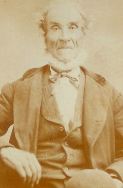
| Description | : | Frank St John was born November 23, 1849 near Porter, Wisconsin on the family homestead. He came to Clayton County, Iowa when he was three years old. He was one of nine children whose parents were Nehemiah and Elmena (Freeman) St John. In 1852 his parents established a farm at the edge of the Clayton-Fayette county line near the town of Arlington. This was his home for nearly eighty years. Frank St John and Marion Ensign were united in marriage at Strawberry Point by the Reverend Stearns on December 3, 1876. He was a... Read More |
frequently asked questions (FAQ):
-
Where is Franklin S. “Frank” St. John's memorial?
Franklin S. “Frank” St. John's memorial is located at: Maumee Cemetery, Antwerp, Paulding County, USA.
-
When did Franklin S. “Frank” St. John death?
Franklin S. “Frank” St. John death on 30 Dec 1930 in Arlington, Fayette County, Iowa, USA
-
Where are the coordinates of the Franklin S. “Frank” St. John's memorial?
Latitude: 41.1889000
Longitude: -84.7244034
Family Members:
Parent
Spouse
Siblings
Flowers:
Nearby Cemetories:
1. Maumee Cemetery
Antwerp, Paulding County, USA
Coordinate: 41.1889000, -84.7244034
2. Riverside Cemetery
Antwerp, Paulding County, USA
Coordinate: 41.1831017, -84.7375031
3. Slough Cemetery
Antwerp, Paulding County, USA
Coordinate: 41.2038994, -84.7144012
4. Banks Cemetery
Paulding County, USA
Coordinate: 41.2028008, -84.7033005
5. Banks Cemetery
Antwerp, Paulding County, USA
Coordinate: 41.1856003, -84.7617035
6. Slough Family Plot
Antwerp, Paulding County, USA
Coordinate: 41.1716440, -84.7746040
7. Bethel Cemetery
Cecil, Paulding County, USA
Coordinate: 41.2238998, -84.6697006
8. Forder Cemetery
Antwerp, Paulding County, USA
Coordinate: 41.2233009, -84.6688995
9. Clark Cemetery
Antwerp, Paulding County, USA
Coordinate: 41.2411003, -84.7514038
10. Diehl Cemetery
Woodburn, Allen County, USA
Coordinate: 41.1721200, -84.8054400
11. Saylor Cemetery
Woodburn, Allen County, USA
Coordinate: 41.1623802, -84.8119507
12. Gordon Cemetery
Paulding County, USA
Coordinate: 41.2318993, -84.6433029
13. Spindler Cemetery
Mark Center, Defiance County, USA
Coordinate: 41.2625008, -84.6697006
14. Vinegar Farm Plot
Paulding, Paulding County, USA
Coordinate: 41.1675410, -84.6029410
15. East Allen County Amish Cemetery
Harlan, Allen County, USA
Coordinate: 41.1844270, -84.8502660
16. Snellenberger Cemetery
Paulding County, USA
Coordinate: 41.0936012, -84.6941986
17. Wiltsie Cemetery
Payne, Paulding County, USA
Coordinate: 41.0894012, -84.7093964
18. Cooper Haines Cemetery
Paulding, Paulding County, USA
Coordinate: 41.1227989, -84.6222000
19. Saint Paul Cemetery
Paulding, Paulding County, USA
Coordinate: 41.1144943, -84.6296768
20. Shell-Sowers Cemetery
Scipio Township, Allen County, USA
Coordinate: 41.2566200, -84.8281380
21. Scipio Cemetery
Scipio Township, Allen County, USA
Coordinate: 41.2496870, -84.8392900
22. Christ Evangelical Lutheran Church Cemetery
Woodburn, Allen County, USA
Coordinate: 41.1365200, -84.8486800
23. Rochester Cemetery
Cecil, Paulding County, USA
Coordinate: 41.2313995, -84.5914001
24. Immaculate Conception Cemetery
Crane Township, Paulding County, USA
Coordinate: 41.2325500, -84.5905100


