
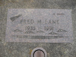
Fred Milton Lane
| Birth | : | 19 Nov 1935 Woodland, Cowlitz County, Washington, USA |
| Death | : | 30 Mar 1991 Vancouver, Clark County, Washington, USA |
| Burial | : | Meahl Cemetery, Robards, Henderson County, USA |
| Coordinate | : | 37.7137860, -87.6146690 |
| Description | : | Fred Milton Lane, 55, of Woodland, died March 30, 1991, in a Vancouver hospital. He was born Nov. 19, 1935, in Woodland, and was raised and educated there. He returned to Woodland in 1985 after living in Alaska many years. He had a 15-year career in the armed forces, serving as a pilot in the Navy, Coast Guard and Marine Corps. He was attached to the Air Sea Rescue Unit in the Coast Guard. In Alaska, he worked 15 years as a bush pilot, and also was a pilot for Alaska Air Lines. His hobbies were hunting, fishing... Read More |
frequently asked questions (FAQ):
-
Where is Fred Milton Lane's memorial?
Fred Milton Lane's memorial is located at: Meahl Cemetery, Robards, Henderson County, USA.
-
When did Fred Milton Lane death?
Fred Milton Lane death on 30 Mar 1991 in Vancouver, Clark County, Washington, USA
-
Where are the coordinates of the Fred Milton Lane's memorial?
Latitude: 37.7137860
Longitude: -87.6146690
Family Members:
Parent

Siblings
Flowers:


Nearby Cemetories:
1. Meahl Cemetery
Robards, Henderson County, USA
Coordinate: 37.7137860, -87.6146690
2. New Sights Cemetery
Robards, Henderson County, USA
Coordinate: 37.7134440, -87.6147710
3. Agnew Cemetery
Cairo, Henderson County, USA
Coordinate: 37.7289009, -87.6219025
4. Denton Cemetery
Henderson, Henderson County, USA
Coordinate: 37.7327995, -87.6168976
5. Busby-Denton Cemetery
Henderson County, USA
Coordinate: 37.7328000, -87.6169000
6. Denton Cemetery
Robards, Henderson County, USA
Coordinate: 37.7159910, -87.5860790
7. Thomas Cemetery
Cairo, Henderson County, USA
Coordinate: 37.7156390, -87.6513370
8. Brown-Konsler Cemetery
Cairo, Henderson County, USA
Coordinate: 37.7242100, -87.6492500
9. Book Cemetery
Robards, Henderson County, USA
Coordinate: 37.7067720, -87.5785500
10. Watson-Thornberry Cemetery
Cairo, Henderson County, USA
Coordinate: 37.7205830, -87.6530830
11. Royster Cemetery
Cairo, Henderson County, USA
Coordinate: 37.6881100, -87.6422600
12. Spencer Cemetery
Henderson, Henderson County, USA
Coordinate: 37.6913986, -87.5772018
13. Gibson Family Farm Cemetery
Henderson County, USA
Coordinate: 37.7136700, -87.6644900
14. Liles Cemetery #1
Cairo, Henderson County, USA
Coordinate: 37.6812050, -87.6497300
15. Liles Cemetery
Cairo, Henderson County, USA
Coordinate: 37.6792350, -87.6525700
16. McMullin Cemetery
Henderson County, USA
Coordinate: 37.6794014, -87.5753021
17. Royster Cemetery
Cairo, Henderson County, USA
Coordinate: 37.7005000, -87.6736800
18. Royster Cemetery #1
Robards, Henderson County, USA
Coordinate: 37.6699100, -87.5849800
19. Gibson Family Cemetery
Corydon, Henderson County, USA
Coordinate: 37.7233600, -87.6794000
20. Busby Cemetery
Robards, Henderson County, USA
Coordinate: 37.6964280, -87.5508640
21. Smith Cemetery
Robards, Henderson County, USA
Coordinate: 37.7028320, -87.5458980
22. Old Salem Cemetery
Robards, Henderson County, USA
Coordinate: 37.6579720, -87.6197220
23. County Farm Cemetery
Corydon, Henderson County, USA
Coordinate: 37.7435040, -87.6854130
24. Royster Cemetery
Robards, Henderson County, USA
Coordinate: 37.6796900, -87.5458900