

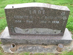
Ruth H Erickson Lane
| Birth | : | 3 Oct 1912 Michigan, USA |
| Death | : | 24 Apr 1998 San Jose, Santa Clara County, California, USA |
| Burial | : | Meahl Cemetery, Robards, Henderson County, USA |
| Coordinate | : | 37.7137860, -87.6146690 |
| Description | : | Ruth Lane, a Woodland, Washington resident for more than 80 years, died April 24 1998 in San Jose, California. She was 85. She was born October 3, 1912 in Michigan. She moved to San Jose two years ago. Mrs Lane loved to garden and enjoyed flowers She was active in the Garden Club, the Dairy Wives and the Hulda Klager Lilac Gardens, all in Woodland, Washington. She also enjoyed reading and ballet. Her husband of 51 years, Emmett ‘‘Pete" Lane preceded her in death, as did a son Fred Lane and a daughter Florine... Read More |
frequently asked questions (FAQ):
-
Where is Ruth H Erickson Lane's memorial?
Ruth H Erickson Lane's memorial is located at: Meahl Cemetery, Robards, Henderson County, USA.
-
When did Ruth H Erickson Lane death?
Ruth H Erickson Lane death on 24 Apr 1998 in San Jose, Santa Clara County, California, USA
-
Where are the coordinates of the Ruth H Erickson Lane's memorial?
Latitude: 37.7137860
Longitude: -87.6146690
Family Members:
Parent

Spouse
Siblings


Children
Flowers:


Nearby Cemetories:
1. Meahl Cemetery
Robards, Henderson County, USA
Coordinate: 37.7137860, -87.6146690
2. New Sights Cemetery
Robards, Henderson County, USA
Coordinate: 37.7134440, -87.6147710
3. Agnew Cemetery
Cairo, Henderson County, USA
Coordinate: 37.7289009, -87.6219025
4. Denton Cemetery
Henderson, Henderson County, USA
Coordinate: 37.7327995, -87.6168976
5. Busby-Denton Cemetery
Henderson County, USA
Coordinate: 37.7328000, -87.6169000
6. Denton Cemetery
Robards, Henderson County, USA
Coordinate: 37.7159910, -87.5860790
7. Thomas Cemetery
Cairo, Henderson County, USA
Coordinate: 37.7156390, -87.6513370
8. Brown-Konsler Cemetery
Cairo, Henderson County, USA
Coordinate: 37.7242100, -87.6492500
9. Book Cemetery
Robards, Henderson County, USA
Coordinate: 37.7067720, -87.5785500
10. Watson-Thornberry Cemetery
Cairo, Henderson County, USA
Coordinate: 37.7205830, -87.6530830
11. Royster Cemetery
Cairo, Henderson County, USA
Coordinate: 37.6881100, -87.6422600
12. Spencer Cemetery
Henderson, Henderson County, USA
Coordinate: 37.6913986, -87.5772018
13. Gibson Family Farm Cemetery
Henderson County, USA
Coordinate: 37.7136700, -87.6644900
14. Liles Cemetery #1
Cairo, Henderson County, USA
Coordinate: 37.6812050, -87.6497300
15. Liles Cemetery
Cairo, Henderson County, USA
Coordinate: 37.6792350, -87.6525700
16. McMullin Cemetery
Henderson County, USA
Coordinate: 37.6794014, -87.5753021
17. Royster Cemetery
Cairo, Henderson County, USA
Coordinate: 37.7005000, -87.6736800
18. Royster Cemetery #1
Robards, Henderson County, USA
Coordinate: 37.6699100, -87.5849800
19. Gibson Family Cemetery
Corydon, Henderson County, USA
Coordinate: 37.7233600, -87.6794000
20. Busby Cemetery
Robards, Henderson County, USA
Coordinate: 37.6964280, -87.5508640
21. Smith Cemetery
Robards, Henderson County, USA
Coordinate: 37.7028320, -87.5458980
22. Old Salem Cemetery
Robards, Henderson County, USA
Coordinate: 37.6579720, -87.6197220
23. County Farm Cemetery
Corydon, Henderson County, USA
Coordinate: 37.7435040, -87.6854130
24. Royster Cemetery
Robards, Henderson County, USA
Coordinate: 37.6796900, -87.5458900