
| Birth | : | 19 May 1881 Fairfield Township, Jackson County, Iowa, USA |
| Death | : | 19 Jun 1940 New Castle, Garfield County, Colorado, USA |
| Burial | : | Highland Cemetery, New Castle, Garfield County, USA |
| Coordinate | : | 39.5875015, -107.5192032 |
| Plot | : | Plot 1, Lot 333 |
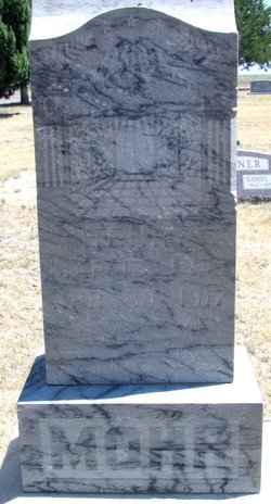
| Inscription | : | Dad Age 59 years 2 months |
| Description | : | Fred was named "Friedrich Heinrich" at birth by his German parents. He later adopted the more Americanized name of "Frederick Henry", and went by "Fred". |
frequently asked questions (FAQ):
-
Where is Frederick Henry “Fred” Mohr's memorial?
Frederick Henry “Fred” Mohr's memorial is located at: Highland Cemetery, New Castle, Garfield County, USA.
-
When did Frederick Henry “Fred” Mohr death?
Frederick Henry “Fred” Mohr death on 19 Jun 1940 in New Castle, Garfield County, Colorado, USA
-
Where are the coordinates of the Frederick Henry “Fred” Mohr's memorial?
Latitude: 39.5875015
Longitude: -107.5192032
Family Members:
Parent
Spouse
Siblings
Children
Flowers:


Nearby Cemetories:
1. Highland Cemetery
New Castle, Garfield County, USA
Coordinate: 39.5875015, -107.5192032
2. Skyline Cemetery
Silt, Garfield County, USA
Coordinate: 39.5520060, -107.6575300
3. Farnum Holt Columbarium
Glenwood Springs, Garfield County, USA
Coordinate: 39.5469640, -107.3299900
4. Union Divide Creek Cemetery
Silt, Garfield County, USA
Coordinate: 39.4508018, -107.6200027
5. Pioneer Cemetery
Glenwood Springs, Garfield County, USA
Coordinate: 39.5392000, -107.3192000
6. Rosebud Cemetery
Glenwood Springs, Garfield County, USA
Coordinate: 39.5168991, -107.3189011
7. Rose Hill Cemetery
Rifle, Garfield County, USA
Coordinate: 39.5381012, -107.7742004
8. Marion Cemetery
Garfield County, USA
Coordinate: 39.3689003, -107.3047028
9. Fisher Cemetery
Carbondale, Garfield County, USA
Coordinate: 39.4791985, -107.1911011
10. Evergreen Cemetery
Carbondale, Garfield County, USA
Coordinate: 39.4077988, -107.2155991
11. Hillcrest Cemetery
Carbondale, Garfield County, USA
Coordinate: 39.3922005, -107.1936035
12. Rulison Cemetery
Rulison, Garfield County, USA
Coordinate: 39.4768000, -107.9357000
13. Dotsero Cemetery
Dotsero, Eagle County, USA
Coordinate: 39.6477600, -107.0672200
14. Blackman Ranch Cemetery
Collbran, Mesa County, USA
Coordinate: 39.2647420, -107.8554350
15. Battlement Cemetery
Parachute, Garfield County, USA
Coordinate: 39.4380989, -108.0291977
16. Cedar Hill Memorial Cemetery
Gypsum, Eagle County, USA
Coordinate: 39.6445990, -106.9600620
17. Russey-Hurlburt Cemetery
Parachute, Garfield County, USA
Coordinate: 39.4522018, -108.0575027
18. Basalt Cemetery
Basalt, Eagle County, USA
Coordinate: 39.3646800, -107.0213100
19. Clover Cemetery
Collbran, Mesa County, USA
Coordinate: 39.2550011, -107.9227982
20. Hillside Cemetery
Redstone, Pitkin County, USA
Coordinate: 39.1843300, -107.2418900
21. Wheatley Cemetery
Pitkin County, USA
Coordinate: 39.3325720, -106.9807170
22. Cedar Crest Cemetery
Collbran, Mesa County, USA
Coordinate: 39.2369003, -107.9589005
23. Saint Benedicts Monastery Cemetery
Snowmass, Pitkin County, USA
Coordinate: 39.2617000, -107.0038000
24. Eagalite Cemetery
Plateau City, Mesa County, USA
Coordinate: 39.2228012, -107.9894028