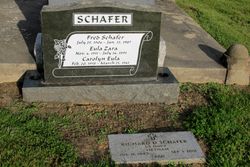
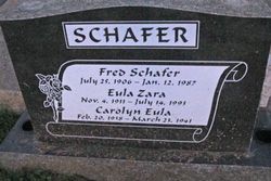
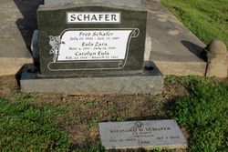
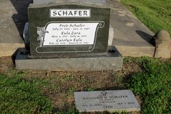
Frederick “Red” Schafer
| Birth | : | 25 Jul 1906 Goff, Nemaha County, Kansas, USA |
| Death | : | 12 Jan 1987 Livermore, Alameda County, California, USA |
| Burial | : | Pleasanton Memorial Gardens Cemetery, Pleasanton, Alameda County, USA |
| Coordinate | : | 37.6466179, -121.8812256 |
| Plot | : | Lot 112 swq, C6, C7 on published map |
| Description | : | Frederick "Red" Schafer Frederick "Red" Schafer, a former Livermore rancher, died Monday, Jan. 12, 1987, at Valley Memorial Hospital in Livermore. He was 80. Schafer, born in Kansas, had been a rancher and farmer all of his adult life. During his 42 years in the Livermore area, he also fitted horseshoes at the race tracks at the Alameda County Fairgrounds in Pleasanton. He had been ill for the past 11 years and retired eight to nine years ago, said his wife Eula. "He was friendly, outgoing and happy," she said. "He was easy to get along with, very independent and... Read More |
frequently asked questions (FAQ):
-
Where is Frederick “Red” Schafer's memorial?
Frederick “Red” Schafer's memorial is located at: Pleasanton Memorial Gardens Cemetery, Pleasanton, Alameda County, USA.
-
When did Frederick “Red” Schafer death?
Frederick “Red” Schafer death on 12 Jan 1987 in Livermore, Alameda County, California, USA
-
Where are the coordinates of the Frederick “Red” Schafer's memorial?
Latitude: 37.6466179
Longitude: -121.8812256
Family Members:
Parent
Spouse
Siblings
Children
Flowers:
Nearby Cemetories:
1. Pleasanton Memorial Gardens Cemetery
Pleasanton, Alameda County, USA
Coordinate: 37.6466179, -121.8812256
2. Saint Augustines Cemetery
Pleasanton, Alameda County, USA
Coordinate: 37.6476250, -121.8811340
3. Holy Cross Orthodox Monastery Burial Site
Castro Valley, Alameda County, USA
Coordinate: 37.6331890, -121.9511560
4. Dublin Cemetery
Dublin, Alameda County, USA
Coordinate: 37.6996040, -121.9384384
5. Oak Knoll Pioneer Memorial Park (Defunct)
Livermore, Alameda County, USA
Coordinate: 37.6770660, -121.7896590
6. Roselawn Cemetery
Livermore, Alameda County, USA
Coordinate: 37.6947000, -121.7734800
7. IOOF Memory Gardens Cemetery
Livermore, Alameda County, USA
Coordinate: 37.6797850, -121.7526100
8. Saint Michaels Cemetery
Livermore, Alameda County, USA
Coordinate: 37.6797790, -121.7519150
9. Dominican Sisters of Mission San Jose Cemetery
Fremont, Alameda County, USA
Coordinate: 37.5342751, -121.9184265
10. Mission San Jose Cemetery
Fremont, Alameda County, USA
Coordinate: 37.5338287, -121.9200745
11. Chapel of the Chimes Memorial Park
Hayward, Alameda County, USA
Coordinate: 37.6110992, -122.0222015
12. Garin Regional Park
Hayward, Alameda County, USA
Coordinate: 37.6365760, -122.0338690
13. Ohlone Indians Cemetery
Fremont, Alameda County, USA
Coordinate: 37.5317001, -121.9344025
14. Irvington Memorial Cemetery
Fremont, Alameda County, USA
Coordinate: 37.5325012, -121.9653015
15. Saint Josephs Cemetery
Fremont, Alameda County, USA
Coordinate: 37.5172005, -121.9175034
16. Centerville Pioneer Cemetery
Fremont, Alameda County, USA
Coordinate: 37.5596504, -122.0080643
17. Lone Tree Cemetery
Hayward, Alameda County, USA
Coordinate: 37.6747017, -122.0483017
18. Saint James Episcopal Church Columbarium
Fremont, Alameda County, USA
Coordinate: 37.5514440, -122.0171910
19. Holy Sepulchre Cemetery
Hayward, Alameda County, USA
Coordinate: 37.6486588, -122.0647125
20. Holy Ghost Cemetery
Fremont, Alameda County, USA
Coordinate: 37.5410995, -122.0132980
21. Mount Saint Joseph Cemetery
Hayward, Alameda County, USA
Coordinate: 37.6685028, -122.0760422
22. Five Pillars Farm Cemetery
Livermore, Alameda County, USA
Coordinate: 37.7262764, -121.7105789
23. Mount Eden Cemetery
Hayward, Alameda County, USA
Coordinate: 37.6384000, -122.1105800
24. Cedar Lawn Memorial Park
Fremont, Alameda County, USA
Coordinate: 37.4646988, -121.9131012

