
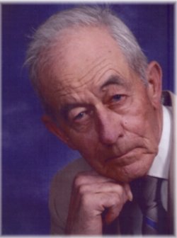
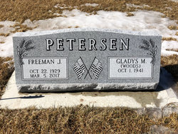


Freeman John Peterson
| Birth | : | 22 Oct 1929 Sheridan County, Nebraska, USA |
| Death | : | 5 Mar 2017 Gordon, Sheridan County, Nebraska, USA |
| Burial | : | Fair View Cemetery, Rushville, Sheridan County, USA |
| Coordinate | : | 42.7155991, -102.4325027 |
| Description | : | Freeman John Petersen, 87, of Gordon, Neb., passed away Sunday, March 5, 2017, in Gordon. He was born south of Rushville, Neb., on Oct. 22, 1929, to John and Martha (Sandoz) Petersen. He attended the public schools of Sheridan County, Nebraska, where he was a lifelong resident. After high school, he worked on the family farm until he joined the Marine Corps where he served from 1951 to 1953 in a Military Police unit at Camp Pendleton, Calif. He worked on the family farm after his military service ended, then worked at the Ford Mercury Dealership as a mechanic and was later... Read More |
frequently asked questions (FAQ):
-
Where is Freeman John Peterson's memorial?
Freeman John Peterson's memorial is located at: Fair View Cemetery, Rushville, Sheridan County, USA.
-
When did Freeman John Peterson death?
Freeman John Peterson death on 5 Mar 2017 in Gordon, Sheridan County, Nebraska, USA
-
Where are the coordinates of the Freeman John Peterson's memorial?
Latitude: 42.7155991
Longitude: -102.4325027
Family Members:
Parent
Siblings

Flowers:


Nearby Cemetories:
1. Saint Marys Cemetery
Rushville, Sheridan County, USA
Coordinate: 42.7174988, -102.4436035
2. Amity Cemetery
Sheridan County, USA
Coordinate: 42.8036003, -102.4389038
3. Preble Cemetery
Sheridan County, USA
Coordinate: 42.6504000, -102.5765000
4. Novotny Cemetery
Hay Springs, Sheridan County, USA
Coordinate: 42.7742004, -102.5963974
5. Mount Hope Cemetery
Gordon, Sheridan County, USA
Coordinate: 42.7113991, -102.2241974
6. Holly Cemetery
Rushville, Sheridan County, USA
Coordinate: 42.8575120, -102.5370990
7. Davis Cemetery
Rushville, Sheridan County, USA
Coordinate: 42.5421000, -102.4118800
8. Gordon Cemetery
Gordon, Sheridan County, USA
Coordinate: 42.7858009, -102.2102966
9. Bomar Cemetery
Hay Springs, Sheridan County, USA
Coordinate: 42.8062000, -102.6459600
10. Saint Aloysius Cemetery
Sheridan County, USA
Coordinate: 42.9015500, -102.4025500
11. Bethel Cemetery
Sheridan County, USA
Coordinate: 42.9011002, -102.3208008
12. St. Mary's Cemetery
Hay Springs, Sheridan County, USA
Coordinate: 42.6721992, -102.7035980
13. Hay Springs Cemetery
Hay Springs, Sheridan County, USA
Coordinate: 42.6702995, -102.7033005
14. Beguin Cemetery
Sheridan County, USA
Coordinate: 42.5107994, -102.4982986
15. Abold Family Cemetery
Rushville, Sheridan County, USA
Coordinate: 42.8863500, -102.6158000
16. Sacred Heart Cemetery
Hay Springs, Sheridan County, USA
Coordinate: 42.5213220, -102.5782690
17. Antelope Cemetery
Hay Springs, Sheridan County, USA
Coordinate: 42.7144970, -102.7727290
18. Highland Cemetery
Hay Springs, Sheridan County, USA
Coordinate: 42.7145500, -102.7727500
19. Dane Cemetery
Cherry County, USA
Coordinate: 42.7924300, -102.0824700
20. White Clay Cemetery
Rushville, Sheridan County, USA
Coordinate: 42.9732820, -102.5667230
21. Beaver Valley Cemetery
Sheridan County, USA
Coordinate: 42.8880997, -102.7517014
22. Saint Peters Cemetery
Sheridan County, USA
Coordinate: 42.4975014, -102.7161026
23. Lavaca Cemetery
Irwin, Cherry County, USA
Coordinate: 42.7332993, -102.0175018
24. Holy Cross Cemetery
Pine Ridge, Oglala Lakota County, USA
Coordinate: 43.0194016, -102.5503006