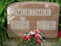
Fuller Henry Mortimer
| Birth | : | 15 Sep 1881 Maidstone, Maidstone Borough, Kent, England |
| Death | : | 23 Sep 1974 Keokuk, Lee County, Iowa, USA |
| Burial | : | St. Peter and St. Paul's Churchyard, Gringley-on-the-Hill, Bassetlaw District, England |
| Coordinate | : | 53.4076320, -0.8944210 |
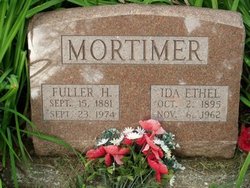
| Description | : | The Daily Gate City Keokuk, Iowa Monday September 23, 1974 Page 10 Column 1 Fuller Mortimer ALEXANDRIA, Mo. -- Fuller Mortimer, 93, Keokuk, died at 4:05 a.m., today, at Keokuk Convalescent Center. His death followed an illness of several months. He was born Sept. 15, 1881, in Maidstone, Kent, England, the son of the late Thomas Henry and Ellen King Mortimer. He married Ethel Logue April 21, 1909,in Keokuk. She preceded him in death Nov. 6, 1962. Mr. Mortimer had been a resident of Alexandria and Keokuk since he was 11 months old. He was employed by the Keokuk and Alexandria Cooper shops during their existence.... Read More |
frequently asked questions (FAQ):
-
Where is Fuller Henry Mortimer's memorial?
Fuller Henry Mortimer's memorial is located at: St. Peter and St. Paul's Churchyard, Gringley-on-the-Hill, Bassetlaw District, England.
-
When did Fuller Henry Mortimer death?
Fuller Henry Mortimer death on 23 Sep 1974 in Keokuk, Lee County, Iowa, USA
-
Where are the coordinates of the Fuller Henry Mortimer's memorial?
Latitude: 53.4076320
Longitude: -0.8944210
Family Members:
Parent
Spouse
Siblings
Children
Flowers:
Nearby Cemetories:
1. Gringley on the Hill Cemetery
Gringley-on-the-Hill, Bassetlaw District, England
Coordinate: 53.4072930, -0.9021230
2. St. Peter's Churchyard
Clayworth, Bassetlaw District, England
Coordinate: 53.3877200, -0.9093960
3. Walkeringham Parish Cemetery
Walkeringham, Bassetlaw District, England
Coordinate: 53.4201430, -0.8463880
4. All Saints Churchyard
Beckingham, Bassetlaw District, England
Coordinate: 53.4037500, -0.8297300
5. Holy Trinity Churchyard
Everton, Bassetlaw District, England
Coordinate: 53.4141740, -0.9614720
6. Everton Cemetery
Everton, Bassetlaw District, England
Coordinate: 53.4088639, -0.9625431
7. All Saints Churchyard
Mattersey, Bassetlaw District, England
Coordinate: 53.3963070, -0.9631660
8. All Saints Churchyard
Misterton, Bassetlaw District, England
Coordinate: 53.4442500, -0.8500830
9. Mattersey Cemetery
Mattersey, Bassetlaw District, England
Coordinate: 53.3986220, -0.9691880
10. St Peter & St Paul Churchyard
North Wheatley, Bassetlaw District, England
Coordinate: 53.3641900, -0.8563900
11. St. Peter's Churchyard
East Stockwith, West Lindsey District, England
Coordinate: 53.4415500, -0.8161400
12. St. Peter's Churchyard
Hayton, Bassetlaw District, England
Coordinate: 53.3494900, -0.9093700
13. Saint Martin's Churchyard
Bole, Bassetlaw District, England
Coordinate: 53.3748200, -0.8093900
14. Blessed Virgin Mary Churchyard
West Stockwith, Bassetlaw District, England
Coordinate: 53.4434410, -0.8117040
15. North Warren Cemetery
Gainsborough, West Lindsey District, England
Coordinate: 53.4105900, -0.7833000
16. St. John the Baptist Churchyard
Clarborough, Bassetlaw District, England
Coordinate: 53.3413200, -0.8981100
17. St Paul Churchyard
Morton, North Kesteven District, England
Coordinate: 53.4137934, -0.7829434
18. Morton-by-Gainsborough Burial Ground
Morton, North Kesteven District, England
Coordinate: 53.4132351, -0.7782703
19. All Saints Churchyard
Gainsborough, West Lindsey District, England
Coordinate: 53.4014800, -0.7763900
20. St. Bartholomew's Churchyard
Sutton cum Lound, Bassetlaw District, England
Coordinate: 53.3573000, -0.9784000
21. St Peter & St Paul Churchyard
Sturton-le-Steeple, Bassetlaw District, England
Coordinate: 53.3500000, -0.8200000
22. Holy Trinity Parish Church
Gainsborough, West Lindsey District, England
Coordinate: 53.3948791, -0.7723334
23. St. John's Churchyard
Gainsborough, West Lindsey District, England
Coordinate: 53.3949589, -0.7722998
24. West Burton old church yard
West Burton, Bassetlaw District, England
Coordinate: 53.3569854, -0.8026078

