
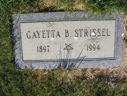
Gayetta B Hayes Strissel
| Birth | : | 17 Dec 1897 Easton, Mason County, Illinois, USA |
| Death | : | 7 Aug 1994 Chester, Liberty County, Montana, USA |
| Burial | : | Rudyard Cemetery, Rudyard, Hill County, USA |
| Coordinate | : | 48.5659500, -110.5390000 |
frequently asked questions (FAQ):
-
Where is Gayetta B Hayes Strissel's memorial?
Gayetta B Hayes Strissel's memorial is located at: Rudyard Cemetery, Rudyard, Hill County, USA.
-
When did Gayetta B Hayes Strissel death?
Gayetta B Hayes Strissel death on 7 Aug 1994 in Chester, Liberty County, Montana, USA
-
Where are the coordinates of the Gayetta B Hayes Strissel's memorial?
Latitude: 48.5659500
Longitude: -110.5390000
Family Members:
Spouse
Children
Flowers:


Nearby Cemetories:
1. Rudyard Cemetery
Rudyard, Hill County, USA
Coordinate: 48.5659500, -110.5390000
2. Hingham Union Cemetery
Hingham, Hill County, USA
Coordinate: 48.5601570, -110.4178980
3. Inverness Cemetery
Hill County, USA
Coordinate: 48.5531340, -110.6688450
4. Bethel Cemetery
Hill County, USA
Coordinate: 48.6685982, -110.6406021
5. Joplin Cemetery
Joplin, Liberty County, USA
Coordinate: 48.5576720, -110.7622930
6. Gildford Hill County Cemetery
Gildford, Hill County, USA
Coordinate: 48.5778008, -110.2957993
7. Cool Spring Colony Cemetery
Rudyard, Hill County, USA
Coordinate: 48.7704000, -110.5860000
8. Milk River Valley Church Graveyard
Hill County, USA
Coordinate: 48.6787180, -110.2261080
9. Cottonwood Lutheran Church Cemetery
Havre, Hill County, USA
Coordinate: 48.4545000, -110.1748000
10. Grace Church Cemetery
Rudyard, Hill County, USA
Coordinate: 48.8269930, -110.6209890
11. Chester Cemetery
Chester, Liberty County, USA
Coordinate: 48.5219002, -110.9807968
12. Saint Wenceslaus Cemetery
Goldstone, Hill County, USA
Coordinate: 48.9002610, -110.5310160
13. Kenilworth Cemetery
Chouteau County, USA
Coordinate: 48.2192001, -110.4188995
14. Erickson Cemetery
Liberty County, USA
Coordinate: 48.3143997, -110.9503021
15. Spring Coulee Cemetery
Hill County, USA
Coordinate: 48.9138985, -110.2035980
16. Box Elder Cemetery
Box Elder, Hill County, USA
Coordinate: 48.3274000, -110.0095000
17. Saint Johns Catholic Cemetery
Havre, Hill County, USA
Coordinate: 48.7625008, -109.9638977
18. Eagle Creek Colony Cemetery
Chester, Liberty County, USA
Coordinate: 48.6976000, -111.2011000
19. Grainbelt Cemetery
Hill County, USA
Coordinate: 48.6828003, -109.8657990
20. Sage Creek Colony Cemetery
Sage Creek Colony, Liberty County, USA
Coordinate: 48.9271000, -110.9735000
21. Lothair Protestant Cemetery
Lothair, Liberty County, USA
Coordinate: 48.4694000, -111.2393100
22. Big Sandy Cemetery
Big Sandy, Chouteau County, USA
Coordinate: 48.1801170, -110.1207500
23. Lothair Catholic Cemetery
Lothair, Liberty County, USA
Coordinate: 48.4687000, -111.2484000
24. Trinity Church Cemetery
Lothair, Liberty County, USA
Coordinate: 48.7263000, -111.2296000