
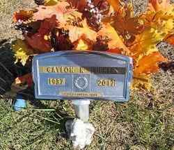
Gaylon Keith Lueker
| Birth | : | 11 Apr 1937 Lost Springs, Marion County, Kansas, USA |
| Death | : | 11 Mar 2017 Abilene, Dickinson County, Kansas, USA |
| Burial | : | Woodbine Cemetery, Woodbine, Dickinson County, USA |
| Coordinate | : | 38.7924995, -96.9636002 |
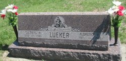
| Description | : | Gaylon K. Lueker, 79, of Junction City; died at Memorial Hospital in Abilene, Saturday, March 11, 2017. He was born April 11, 1937, the son of Clemens A.and Florence K. (Langhofer) Lueker. Visitation will be 6:30 – 8:30 pm, Thursday, March 16th, 2017, at the Zeiner Funeral Home-Herington Chapel. Military committal services will follow at the Woodbine Cemetery. Gaylon was baptized and confirmed at Immanuel Lutheran Church of Shady Brook. He graduated from Woodbine High School with the class of 1955. Following high school he went to work as a meat cutter at the IGA in... Read More |
frequently asked questions (FAQ):
-
Where is Gaylon Keith Lueker's memorial?
Gaylon Keith Lueker's memorial is located at: Woodbine Cemetery, Woodbine, Dickinson County, USA.
-
When did Gaylon Keith Lueker death?
Gaylon Keith Lueker death on 11 Mar 2017 in Abilene, Dickinson County, Kansas, USA
-
Where are the coordinates of the Gaylon Keith Lueker's memorial?
Latitude: 38.7924995
Longitude: -96.9636002
Family Members:
Parent

Flowers:


Nearby Cemetories:
1. Woodbine Cemetery
Woodbine, Dickinson County, USA
Coordinate: 38.7924995, -96.9636002
2. Langhofer-Riffel Cemetery
Woodbine, Dickinson County, USA
Coordinate: 38.7835530, -96.9874660
3. Langhofer Cemetery
Woodbine, Dickinson County, USA
Coordinate: 38.7905530, -96.9921110
4. Lyons Creek German Baptist Cemetery
Woodbine, Dickinson County, USA
Coordinate: 38.7672680, -96.9645600
5. Immanuel Lutheran Cemetery
Shady Brook, Dickinson County, USA
Coordinate: 38.7392890, -96.9842260
6. Saint Paul Cemetery
Shady Brook, Dickinson County, USA
Coordinate: 38.7358017, -96.9816971
7. Fall Cemetery
Herington, Dickinson County, USA
Coordinate: 38.7324440, -96.9642810
8. Riffel Cemetery (Defunct)
Woodbine, Dickinson County, USA
Coordinate: 38.8177986, -97.0342026
9. Lyona Methodist Church Cemetery
Lyona, Dickinson County, USA
Coordinate: 38.8630400, -96.9266500
10. Clarks Creek Cemetery
Latimer, Morris County, USA
Coordinate: 38.7821999, -96.8664017
11. Saint Johns Cemetery
White City, Morris County, USA
Coordinate: 38.8093987, -96.8531036
12. Mount Zion Cemetery
Junction City, Geary County, USA
Coordinate: 38.8762000, -96.9267080
13. Zion Lutheran Cemetery
Latimer, Morris County, USA
Coordinate: 38.7542000, -96.8578033
14. Blanchett Cemetery
Herington, Dickinson County, USA
Coordinate: 38.7000130, -96.9765330
15. Mollhagen Gravesite
Herington, Dickinson County, USA
Coordinate: 38.6979350, -96.9874040
16. Chalker Cemetery
Herington, Dickinson County, USA
Coordinate: 38.7032010, -97.0104170
17. Saint Johns Lutheran Cemetery
Herington, Dickinson County, USA
Coordinate: 38.6957512, -96.9995117
18. Rinehart Cemetery
Enterprise, Dickinson County, USA
Coordinate: 38.9021988, -96.9638977
19. Navarre Cemetery
Navarre, Dickinson County, USA
Coordinate: 38.7957115, -97.1080627
20. Sunset Hill Cemetery
Herington, Dickinson County, USA
Coordinate: 38.6777992, -96.9561005
21. Pilgrim Home Cemetery
Hope, Dickinson County, USA
Coordinate: 38.7257996, -97.0852966
22. Pleasant Hill Cemetery
Enterprise, Dickinson County, USA
Coordinate: 38.8885150, -97.0749560
23. Hope Cemetery
Hope, Dickinson County, USA
Coordinate: 38.6924057, -97.0706329
24. Saint Phillips Cemetery
Hope, Dickinson County, USA
Coordinate: 38.6810989, -97.0507965