
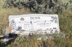
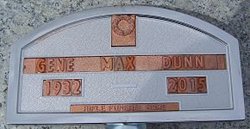
Gene Max Dunn
| Birth | : | 29 Mar 1932 Garfield County, Colorado, USA |
| Death | : | 7 Oct 2015 Silt, Garfield County, Colorado, USA |
| Burial | : | Union Divide Creek Cemetery, Silt, Garfield County, USA |
| Coordinate | : | 39.4508018, -107.6200027 |
| Inscription | : | Dunn Gene M. Mar. 29, 1932 Oct. 7, 2015 Married July 5, 1959 Beloved Husband & Father |
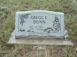
| Description | : | Gene Dunn, of Silt, passed away October 7, 2015 at home surrounded by his family. Gene was born at his grandparents' home on Divide Creek to Howard and Arvilla Dunn. He is survived by his wife, Beth; daughters, Karen (Gary) of Elko, NV; Jennifer Shepard (Ronnie Aldrich) of Silt; grandson, Tyler Dunn of Rifle; granddaughters, Audrina and Alyssa Shepard of Coeur d'Alene, ID; sister, Carmen Wood of Grand Junction; brother-in-law, Doug Sours of Rifle; sister and brother-in-law, Pauline and Gary Haas of Silt, and nieces, nephews, and cousins. He was preceded in death by his son, Gregg Dunn; parents, Howard... Read More |
frequently asked questions (FAQ):
-
Where is Gene Max Dunn's memorial?
Gene Max Dunn's memorial is located at: Union Divide Creek Cemetery, Silt, Garfield County, USA.
-
When did Gene Max Dunn death?
Gene Max Dunn death on 7 Oct 2015 in Silt, Garfield County, Colorado, USA
-
Where are the coordinates of the Gene Max Dunn's memorial?
Latitude: 39.4508018
Longitude: -107.6200027
Family Members:
Parent

Children
Flowers:


Nearby Cemetories:
1. Union Divide Creek Cemetery
Silt, Garfield County, USA
Coordinate: 39.4508018, -107.6200027
2. Skyline Cemetery
Silt, Garfield County, USA
Coordinate: 39.5520060, -107.6575300
3. Rose Hill Cemetery
Rifle, Garfield County, USA
Coordinate: 39.5381012, -107.7742004
4. Highland Cemetery
New Castle, Garfield County, USA
Coordinate: 39.5875015, -107.5192032
5. Rosebud Cemetery
Glenwood Springs, Garfield County, USA
Coordinate: 39.5168991, -107.3189011
6. Farnum Holt Columbarium
Glenwood Springs, Garfield County, USA
Coordinate: 39.5469640, -107.3299900
7. Rulison Cemetery
Rulison, Garfield County, USA
Coordinate: 39.4768000, -107.9357000
8. Pioneer Cemetery
Glenwood Springs, Garfield County, USA
Coordinate: 39.5392000, -107.3192000
9. Marion Cemetery
Garfield County, USA
Coordinate: 39.3689003, -107.3047028
10. Blackman Ranch Cemetery
Collbran, Mesa County, USA
Coordinate: 39.2647420, -107.8554350
11. Clover Cemetery
Collbran, Mesa County, USA
Coordinate: 39.2550011, -107.9227982
12. Evergreen Cemetery
Carbondale, Garfield County, USA
Coordinate: 39.4077988, -107.2155991
13. Battlement Cemetery
Parachute, Garfield County, USA
Coordinate: 39.4380989, -108.0291977
14. Fisher Cemetery
Carbondale, Garfield County, USA
Coordinate: 39.4791985, -107.1911011
15. Hillcrest Cemetery
Carbondale, Garfield County, USA
Coordinate: 39.3922005, -107.1936035
16. Russey-Hurlburt Cemetery
Parachute, Garfield County, USA
Coordinate: 39.4522018, -108.0575027
17. Cedar Crest Cemetery
Collbran, Mesa County, USA
Coordinate: 39.2369003, -107.9589005
18. Eagalite Cemetery
Plateau City, Mesa County, USA
Coordinate: 39.2228012, -107.9894028
19. Hillside Cemetery
Redstone, Pitkin County, USA
Coordinate: 39.1843300, -107.2418900
20. Molina Cemetery
Molina, Mesa County, USA
Coordinate: 39.1886000, -108.0629000
21. Prospect Mountain Ranch Cemetery
Marble, Gunnison County, USA
Coordinate: 39.0927230, -107.2395980
22. Dotsero Cemetery
Dotsero, Eagle County, USA
Coordinate: 39.6477600, -107.0672200
23. Basalt Cemetery
Basalt, Eagle County, USA
Coordinate: 39.3646800, -107.0213100
24. DeBeque Cemetery
Mesa County, USA
Coordinate: 39.3374060, -108.2138900