
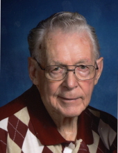
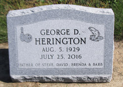
George Dale Herington
| Birth | : | 5 Aug 1929 Rowley, Buchanan County, Iowa, USA |
| Death | : | 25 Jul 2016 Waterloo, Black Hawk County, Iowa, USA |
| Burial | : | Rowley Cemetery, Rowley, Buchanan County, USA |
| Coordinate | : | 42.3716621, -91.8530655 |
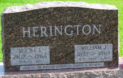
| Description | : | George Dale Herington, 86, of Waterloo, died Monday, July 25, at UnityPoint Health-Allen Hospital. He was born August 5, 1929 in Rowley, son of William and Mabel Metcalf Herington. He married Edna McGuire. They were later divorced. He later married Jackie (Jaceil) Mostek on January 30, 2005 in Independence. George worked at Quaker Oats, Hoxie Fruit Company, McDonalds and Fairview Cemetery. He was a veteran of the U. S. Army. Survivors include: his wife; a daughter, Barb (Steve) Patchin of Wateloo; a son, David Herington of Fort Dodge; a step-daughter, Cynthia Mostek of Waterloo; three step-sons, Mike (Barb) Mostek of Jesup, Tim Mostek... Read More |
frequently asked questions (FAQ):
-
Where is George Dale Herington's memorial?
George Dale Herington's memorial is located at: Rowley Cemetery, Rowley, Buchanan County, USA.
-
When did George Dale Herington death?
George Dale Herington death on 25 Jul 2016 in Waterloo, Black Hawk County, Iowa, USA
-
Where are the coordinates of the George Dale Herington's memorial?
Latitude: 42.3716621
Longitude: -91.8530655
Family Members:
Parent

Spouse

Siblings
Flowers:


Nearby Cemetories:
1. Rowley Cemetery
Rowley, Buchanan County, USA
Coordinate: 42.3716621, -91.8530655
2. Pine Creek Cemetery
Quasqueton, Buchanan County, USA
Coordinate: 42.4172400, -91.7867200
3. Quasqueton Cemetery
Quasqueton, Buchanan County, USA
Coordinate: 42.3994370, -91.7621231
4. Cono Cemetery
Rowley, Buchanan County, USA
Coordinate: 42.3174170, -91.7769370
5. Spencers Grove Cemetery
Benton County, USA
Coordinate: 42.2841988, -91.8655014
6. Hickory Grove Cemetery
Quasqueton, Buchanan County, USA
Coordinate: 42.4207598, -91.7534684
7. Mount Hope Cemetery
Independence, Buchanan County, USA
Coordinate: 42.4571991, -91.8914032
8. State Hospital Cemetery
Independence, Buchanan County, USA
Coordinate: 42.4455986, -91.9253006
9. West Haven Cemetery
Independence, Buchanan County, USA
Coordinate: 42.4588678, -91.8986696
10. Wilson Cemetery
Independence, Buchanan County, USA
Coordinate: 42.4658012, -91.8516998
11. Sacred Heart Cemetery
Walker, Linn County, USA
Coordinate: 42.2938995, -91.7778015
12. Oakwood Cemetery
Independence, Buchanan County, USA
Coordinate: 42.4627991, -91.8927994
13. Walker Cemetery
Walker, Linn County, USA
Coordinate: 42.2840000, -91.7868000
14. Greenwood Cemetery
Brandon, Buchanan County, USA
Coordinate: 42.3123970, -91.9651640
15. Saint Marys Cemetery
Benton County, USA
Coordinate: 42.2616997, -91.8683014
16. Circle Grove Cemetery
Quasqueton, Buchanan County, USA
Coordinate: 42.3386002, -91.7061005
17. Saint Johns Catholic Cemetery
Independence, Buchanan County, USA
Coordinate: 42.4822006, -91.8957977
18. Buchanan County Poor Farm Cemetery
Independence, Buchanan County, USA
Coordinate: 42.4871560, -91.8647280
19. Jefferson Township Cemetery
Brandon, Buchanan County, USA
Coordinate: 42.3139000, -91.9931030
20. Brandon Cemetery
Brandon, Buchanan County, USA
Coordinate: 42.3156300, -91.9945200
21. Buchanan County Home Cemetery
Independence, Buchanan County, USA
Coordinate: 42.4903050, -91.8596350
22. Beachler Cemetery
Brandon, Buchanan County, USA
Coordinate: 42.3045000, -91.9908000
23. Fairview Cemetery
Winthrop, Buchanan County, USA
Coordinate: 42.4692001, -91.7407990
24. Saint Patricks Cemetery
Winthrop, Buchanan County, USA
Coordinate: 42.4653015, -91.7328033