
| Birth | : | 31 Jan 1887 |
| Death | : | 26 Aug 1950 |
| Burial | : | Arlington Memorial Gardens, Mount Healthy, Hamilton County, USA |
| Coordinate | : | 39.2280998, -84.5614014 |
| Plot | : | Block 89, Section 100 |
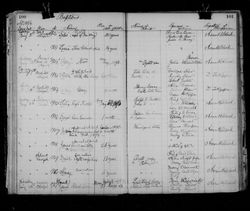
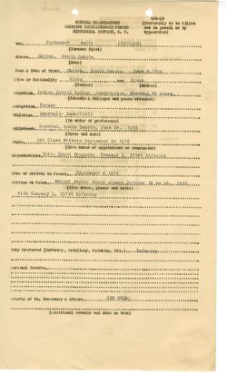
| Description | : | Rosebud Episcopal Mission Church Records 1875-1993, Book DS/II (Dallas Shaw collection), Film #007856516, Image 534 of 554. Record shows George Gunhammer, age 61, died 26 Aug 1950, that his last residence was Rosebud, SD, and that he was buried 29 Aug 1950, Edward O. Moore officiating the funeral. 1900 Meyer County Census shows this family living in House #799: Isidore Gunhammer, 33, head of household, b. 3-1867 in Nebraska. Father's place of birth is listed as unknown and mother's place of birth is listed as Wyoming. He has been married 11 years. White Cow, Rose, 29, wife,... Read More |
frequently asked questions (FAQ):
-
Where is George Gunhammer's memorial?
George Gunhammer's memorial is located at: Arlington Memorial Gardens, Mount Healthy, Hamilton County, USA.
-
When did George Gunhammer death?
George Gunhammer death on 26 Aug 1950 in
-
Where are the coordinates of the George Gunhammer's memorial?
Latitude: 39.2280998
Longitude: -84.5614014
Family Members:
Parent

Siblings
Flowers:


Nearby Cemetories:
1. Arlington Memorial Gardens
Mount Healthy, Hamilton County, USA
Coordinate: 39.2280998, -84.5614014
2. Hoffner Cemetery
Mount Healthy, Hamilton County, USA
Coordinate: 39.2297668, -84.5468903
3. Laboiteaux-Cary Cemetery
North College Hill, Hamilton County, USA
Coordinate: 39.2181015, -84.5500031
4. Compton Cemetery
Colerain Township, Hamilton County, USA
Coordinate: 39.2367700, -84.5760700
5. Mount Pleasant Cemetery
Mount Healthy, Hamilton County, USA
Coordinate: 39.2330200, -84.5430600
6. Saint Marys Cemetery
Mount Healthy, Hamilton County, USA
Coordinate: 39.2329900, -84.5427000
7. Gard-Brown Cemetery
North Bend, Hamilton County, USA
Coordinate: 39.2035200, -84.5553300
8. Springdale Road Baptist Cemetery
Hamilton County, USA
Coordinate: 39.2580986, -84.5717010
9. Gutzwillers Grove Cemetery
Hamilton County, USA
Coordinate: 39.2036018, -84.5875015
10. Barnes Family Cemetery
Colerain Township, Hamilton County, USA
Coordinate: 39.2153600, -84.6018680
11. Jessup Cemetery
Mount Airy, Hamilton County, USA
Coordinate: 39.1970870, -84.5794270
12. New Burlington Cemetery
Springfield Township, Hamilton County, USA
Coordinate: 39.2625008, -84.5468979
13. White Oak Christian Churchyard
Cincinnati, Hamilton County, USA
Coordinate: 39.2212770, -84.6073990
14. Bishop Cemetery (Defunct)
College Hill, Hamilton County, USA
Coordinate: 39.1910210, -84.5489570
15. Olive Branch Methodist Churchyard
Colerain Township, Hamilton County, USA
Coordinate: 39.2193620, -84.6099650
16. Saint James Cemetery
White Oak, Hamilton County, USA
Coordinate: 39.2048000, -84.6012000
17. James Moore Family Cemetery
Wildbrook Acres, Hamilton County, USA
Coordinate: 39.2442741, -84.5157166
18. LaRue-Gardner Family Cemetery
Wyoming Meadows, Hamilton County, USA
Coordinate: 39.2347603, -84.5071411
19. Lingo Family Cemetery
Cincinnati, Hamilton County, USA
Coordinate: 39.1903360, -84.5896670
20. Bevis Cedar Grove Cemetery
Bevis, Hamilton County, USA
Coordinate: 39.2580986, -84.6027985
21. Old Finneytown Cemetery
Finneytown, Hamilton County, USA
Coordinate: 39.1962220, -84.5206120
22. Saint Paul Evangelical Churchyard Cemetery
Colerain Township, Hamilton County, USA
Coordinate: 39.2313576, -84.6247253
23. Convent of the Good Shepherd Cemetery (Defunct)
Carthage, Hamilton County, USA
Coordinate: 39.2055250, -84.5042780
24. Asbury Cemetery
White Oak, Hamilton County, USA
Coordinate: 39.1889420, -84.6053696