
| Memorials | : | 0 |
| Location | : | Carthage, Hamilton County, USA |
| Coordinate | : | 39.2055250, -84.5042780 |
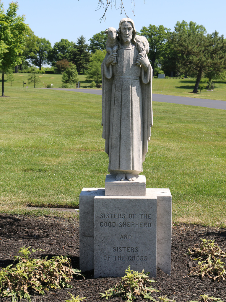
| Description | : | All burials in the cemetery were moved to the Gate of Heaven Cemetery, Montgomery, Hamilton County, Ohio in 1972. The first burial in the cemetery occurred in 1871. The cemetery was 2 acres in size. The cemetery was located in Carthage, now part of the City of Cincinnati, Hamilton County, Ohio, and is # 15163 (Convent of the Good Shepherd Cemetery / Girls Town Cemetery) in “Ohio Cemeteries 1803-2003”, compiled by the Ohio Genealogical Society. |
frequently asked questions (FAQ):
-
Where is Convent of the Good Shepherd Cemetery (Defunct)?
Convent of the Good Shepherd Cemetery (Defunct) is located at North Bend Road Carthage, Hamilton County ,Ohio , 45224USA.
-
Convent of the Good Shepherd Cemetery (Defunct) cemetery's updated grave count on graveviews.com?
0 memorials
-
Where are the coordinates of the Convent of the Good Shepherd Cemetery (Defunct)?
Latitude: 39.2055250
Longitude: -84.5042780
Nearby Cemetories:
1. Old Finneytown Cemetery
Finneytown, Hamilton County, USA
Coordinate: 39.1962220, -84.5206120
2. City Infirmary Cemetery
Hartwell, Hamilton County, USA
Coordinate: 39.2123500, -84.4806700
3. Griffins Station Cemetery
Carthage, Hamilton County, USA
Coordinate: 39.2047000, -84.4770730
4. Saint Clare Convent Cemetery
Mount Healthy, Hamilton County, USA
Coordinate: 39.2206750, -84.4782390
5. LaRue-Gardner Family Cemetery
Wyoming Meadows, Hamilton County, USA
Coordinate: 39.2347603, -84.5071411
6. Longview Hospital Cemetery
Roselawn, Hamilton County, USA
Coordinate: 39.1887730, -84.4691660
7. Beech Grove Cemetery
Springfield Township, Hamilton County, USA
Coordinate: 39.2364006, -84.4916992
8. Bishop Cemetery (Defunct)
College Hill, Hamilton County, USA
Coordinate: 39.1910210, -84.5489570
9. Laboiteaux-Cary Cemetery
North College Hill, Hamilton County, USA
Coordinate: 39.2181015, -84.5500031
10. Gard-Brown Cemetery
North Bend, Hamilton County, USA
Coordinate: 39.2035200, -84.5553300
11. James Moore Family Cemetery
Wildbrook Acres, Hamilton County, USA
Coordinate: 39.2442741, -84.5157166
12. Saint Marys Cemetery
Mount Healthy, Hamilton County, USA
Coordinate: 39.2329900, -84.5427000
13. Mount Pleasant Cemetery
Mount Healthy, Hamilton County, USA
Coordinate: 39.2330200, -84.5430600
14. Hoffner Cemetery
Mount Healthy, Hamilton County, USA
Coordinate: 39.2297668, -84.5468903
15. Saint Mary Cemetery
Saint Bernard, Hamilton County, USA
Coordinate: 39.1664009, -84.4880981
16. Saint John Cemetery
Saint Bernard, Hamilton County, USA
Coordinate: 39.1643982, -84.5053024
17. Spring Grove Cemetery
Cincinnati, Hamilton County, USA
Coordinate: 39.1647900, -84.5231500
18. Arlington Memorial Gardens
Mount Healthy, Hamilton County, USA
Coordinate: 39.2280998, -84.5614014
19. Voorhees Family Burying Ground
Lockland, Hamilton County, USA
Coordinate: 39.2296982, -84.4480972
20. Vine Street Hill Cemetery
Cincinnati, Hamilton County, USA
Coordinate: 39.1516991, -84.5091019
21. Reading Cemetery
Reading, Hamilton County, USA
Coordinate: 39.2296982, -84.4419022
22. Wesleyan Cemetery
Cincinnati, Hamilton County, USA
Coordinate: 39.1599998, -84.5468979
23. First German Protestant Cemetery
Avondale, Hamilton County, USA
Coordinate: 39.1492004, -84.4863968
24. Jessup Cemetery
Mount Airy, Hamilton County, USA
Coordinate: 39.1970870, -84.5794270