
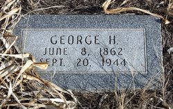
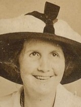
George H. Hagaman
| Birth | : | 8 Jun 1862 Livingston County, Illinois, USA |
| Death | : | 20 Sep 1944 Alliance, Box Butte County, Nebraska, USA |
| Burial | : | St. Michael's Churchyard, Monkton Combe, Bath and North East Somerset Unitary Authority, England |
| Coordinate | : | 51.3559540, -2.3285700 |
| Description | : | Obituary: Alliance Times, Sept. 20, 1944: PONEER RANCHER WAS WELL KNOWN George H. Hagaman, 82, who died Wednesday at his home in Alliance, was one of the early settlers laying the foundation for the ranching industry of the panhandle. Born in Livingston county, Ill; on June 8, 1862, Mr. Hagaman was the youngest of a family of six children, left fatherless when the senior George Hagaman died with Sherman's men on their march to the sea. Orphaned by the death of his mother, when he was eight years old, Mr. Hagaman reached manhood with experience in farm... Read More |
frequently asked questions (FAQ):
-
Where is George H. Hagaman's memorial?
George H. Hagaman's memorial is located at: St. Michael's Churchyard, Monkton Combe, Bath and North East Somerset Unitary Authority, England.
-
When did George H. Hagaman death?
George H. Hagaman death on 20 Sep 1944 in Alliance, Box Butte County, Nebraska, USA
-
Where are the coordinates of the George H. Hagaman's memorial?
Latitude: 51.3559540
Longitude: -2.3285700
Family Members:
Spouse
Children
Flowers:


Nearby Cemetories:
1. St. Michael's Churchyard
Monkton Combe, Bath and North East Somerset Unitary Authority, England
Coordinate: 51.3559540, -2.3285700
2. Union Chapel
Combe Down, Bath and North East Somerset Unitary Authority, England
Coordinate: 51.3594751, -2.3443662
3. Prior Park College
Bath, Bath and North East Somerset Unitary Authority, England
Coordinate: 51.3645990, -2.3442400
4. Jewish Burial Ground
Combe Down, Bath and North East Somerset Unitary Authority, England
Coordinate: 51.3599170, -2.3534670
5. Midford Burial Ground
Bath, Bath and North East Somerset Unitary Authority, England
Coordinate: 51.3394360, -2.3391424
6. St John the Evangelist Cemetery
Bath, Bath and North East Somerset Unitary Authority, England
Coordinate: 51.3696700, -2.3487400
7. Bath Abbey Cemetery
Widcombe, Bath and North East Somerset Unitary Authority, England
Coordinate: 51.3712850, -2.3483060
8. St Thomas à Becket's Church
Widcombe, Bath and North East Somerset Unitary Authority, England
Coordinate: 51.3734250, -2.3465560
9. Unitarian Chapel Burial Ground
Widcombe, Bath and North East Somerset Unitary Authority, England
Coordinate: 51.3704650, -2.3539270
10. St. Mary The Virgin Churchyard
Bathwick, Bath and North East Somerset Unitary Authority, England
Coordinate: 51.3759930, -2.3411930
11. Smallcombe Vale Cemetery
Bathwick, Bath and North East Somerset Unitary Authority, England
Coordinate: 51.3757400, -2.3429400
12. Freshford Cemetery
Freshford, Bath and North East Somerset Unitary Authority, England
Coordinate: 51.3379620, -2.3082970
13. Saint Peters Churchyard
Freshford, Bath and North East Somerset Unitary Authority, England
Coordinate: 51.3400570, -2.3033340
14. Quaker Burial Ground
Widcombe, Bath and North East Somerset Unitary Authority, England
Coordinate: 51.3744350, -2.3498460
15. St. James' Churchyard
South Stoke, Bath and North East Somerset Unitary Authority, England
Coordinate: 51.3497220, -2.3652780
16. St. Mary's Churchyard
Claverton, Bath and North East Somerset Unitary Authority, England
Coordinate: 51.3757560, -2.3061500
17. Claverton Cemetery
Bath, Bath and North East Somerset Unitary Authority, England
Coordinate: 51.3758190, -2.3060720
18. Abbey & St James' Graveyard for the Poor
Widcombe, Bath and North East Somerset Unitary Authority, England
Coordinate: 51.3753550, -2.3545640
19. Old Baptist Burial Ground
Walcot, Bath and North East Somerset Unitary Authority, England
Coordinate: 51.3755070, -2.3544360
20. Baptist Burial Ground
Widcombe, Bath and North East Somerset Unitary Authority, England
Coordinate: 51.3764216, -2.3556947
21. Bath Union Workhouse Graveyard
Bath, Bath and North East Somerset Unitary Authority, England
Coordinate: 51.3584160, -2.3711140
22. Saint Mark's Churchyard
Widcombe, Bath and North East Somerset Unitary Authority, England
Coordinate: 51.3766660, -2.3588010
23. St Mary Magdalen Chapel
Widcombe, Bath and North East Somerset Unitary Authority, England
Coordinate: 51.3760486, -2.3643405
24. Old Orchard Street Catholic Burial Vault
Bath, Bath and North East Somerset Unitary Authority, England
Coordinate: 51.3800370, -2.3579910