
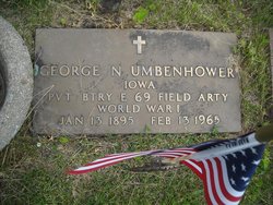
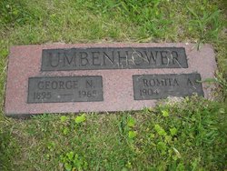
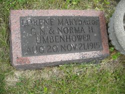
George Nathan Umbenhower
| Birth | : | 13 Jan 1895 Lucas County, Iowa, USA |
| Death | : | 13 Feb 1965 Des Moines, Polk County, Iowa, USA |
| Burial | : | Mountain View Cemetery, Little Current, Manitoulin District, Canada |
| Coordinate | : | 45.9604400, -81.9523100 |
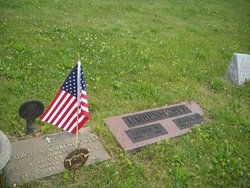
| Plot | : | Row 8 Grave 8 |
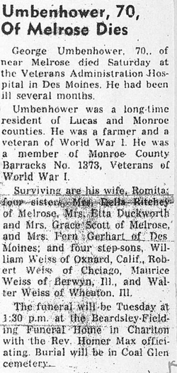
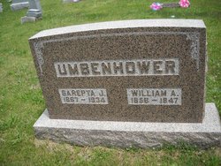
| Description | : | Husband of Norma H. Scott, divorced and Romita Adella Weiss. Son of William Andrew Umbenhower and Sarepta Jane Umbenhower OBITUARY THE CHARITON HERALD-PATRIOT Chariton, Iowa Thursday, February 25, 1965 GEORGE UMBENHOWER George Nathan Umbenhower was born in Lucas county, Iowa, Jan. 13, 1895, to Mr. and Mrs. William Andrew Umbenhower and passed away at the Veterans hospital in Des Moines, Saturday, Feb. 13, 1965. The latter part of his life was lived in and near Chariton. He was united in marriage to Romita Adella Weiss on Oct. 25, 1941 and is survived by his wife, Romita and four sons: William Weiss, Oxnard, Calif.; Robert Weiss, Chicago, Ill.;... Read More |
frequently asked questions (FAQ):
-
Where is George Nathan Umbenhower's memorial?
George Nathan Umbenhower's memorial is located at: Mountain View Cemetery, Little Current, Manitoulin District, Canada.
-
When did George Nathan Umbenhower death?
George Nathan Umbenhower death on 13 Feb 1965 in Des Moines, Polk County, Iowa, USA
-
Where are the coordinates of the George Nathan Umbenhower's memorial?
Latitude: 45.9604400
Longitude: -81.9523100
Family Members:
Parent
Spouse
Siblings
Children
Flowers:


Nearby Cemetories:
1. Mountain View Cemetery
Little Current, Manitoulin District, Canada
Coordinate: 45.9604400, -81.9523100
2. Holy Trinity Anglican Cemetery
Little Current, Manitoulin District, Canada
Coordinate: 45.9677590, -81.9439240
3. Sucker Creek Cemetery
Sucker Creek, Manitoulin District, Canada
Coordinate: 45.9604060, -81.9764140
4. St. Bernard's Catholic Cemetery
Little Current, Manitoulin District, Canada
Coordinate: 45.9789170, -81.9596700
5. Elm View Cemetery
Howland, Manitoulin District, Canada
Coordinate: 45.9045270, -81.9204550
6. Sheguiandah Reserve Cemetery
Sheguiandah, Manitoulin District, Canada
Coordinate: 45.8809640, -81.9049780
7. Green Bay United Church Cemetery
Manitoulin, Manitoulin District, Canada
Coordinate: 45.8603520, -82.0223110
8. Cold Springs Cemetery
Cold Springs, Manitoulin District, Canada
Coordinate: 45.8595060, -82.1087820
9. Birch Island Cemetery
Birch Island, Manitoulin District, Canada
Coordinate: 46.0676300, -81.7714000
10. Whitefish River First Nation Cemetery
Birch Island, Manitoulin District, Canada
Coordinate: 46.0676300, -81.7714000
11. M'Chigeeng Cemetery
West Bay, Manitoulin District, Canada
Coordinate: 45.8163400, -82.1601200
12. Whitefish Falls St. Augustine Anglican Cemetery
Whitefish Falls, Sudbury District, Canada
Coordinate: 46.1142070, -81.7313145
13. Kagawong Cedars Cemetery
Kagawong, Manitoulin District, Canada
Coordinate: 45.9089600, -82.2568300
14. Sagamok New Cemetery
Sagamok, Algoma District, Canada
Coordinate: 46.1582040, -82.1007238
15. Big Lake Cemetery
Manitoulin, Manitoulin District, Canada
Coordinate: 45.7457500, -82.0575900
16. Buzwah Cemetery
Buzwah, Manitoulin District, Canada
Coordinate: 45.7660100, -81.7644500
17. Spanish River First Nations Cemetery
Massey, Sudbury District, Canada
Coordinate: 46.1701900, -82.1068600
18. St. Paul's Anglican Cemetery
Manitowaning, Manitoulin District, Canada
Coordinate: 45.7447912, -81.8061589
19. Lee Valley Cemetery
Lee Valley, Sudbury District, Canada
Coordinate: 46.2015500, -81.9442670
20. St. Christopher's Anglican Cemetery
McGregor Bay, Manitoulin District, Canada
Coordinate: 46.0842340, -81.6429140
21. Old River Road Cemetery
Massey, Sudbury District, Canada
Coordinate: 46.1742260, -82.1342000
22. Zion Lutheran Cemetery
Massey, Sudbury District, Canada
Coordinate: 46.1968900, -82.0623000
23. Sagamok Old Cemetery
Massey, Sudbury District, Canada
Coordinate: 46.2115590, -82.0793450
24. Mindemoya Cemetery
Mindemoya, Manitoulin District, Canada
Coordinate: 45.7473100, -82.1928000