
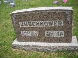
William Andrew Umbenhower
| Birth | : | 17 Feb 1858 Champaign County, Illinois, USA |
| Death | : | 9 Jul 1947 Millerton, Wayne County, Iowa, USA |
| Burial | : | Kagawong Cedars Cemetery, Kagawong, Manitoulin District, Canada |
| Coordinate | : | 45.9089600, -82.2568300 |
| Plot | : | Row 6 Grave 4 |
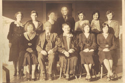
| Description | : | Husband of Sarepta Jane Umbenhower. Son of Isaiah Umbenhower and Matilda Hays OBITUARY THE CHARITON LEADER Chariton, Iowa Tuesday, July 15, 1947 WILLIAM A. UMBENHOWER Mr. William Andrew Umbenhower died at the home of his daughter, Mrs. Morris Scott, of Millerton, after a long illness. He was the son of Isaiah and Matilda Hayes Umbenhower, and was born in Champaign county, Illinois, on February 17, 1858, and passed away July 9, 1947, at the age of 89 years, four months and 22 days. When a small child he moved with his parents by covered wagon to Iowa. His mother took ill on the way and passed away... Read More |
frequently asked questions (FAQ):
-
Where is William Andrew Umbenhower's memorial?
William Andrew Umbenhower's memorial is located at: Kagawong Cedars Cemetery, Kagawong, Manitoulin District, Canada.
-
When did William Andrew Umbenhower death?
William Andrew Umbenhower death on 9 Jul 1947 in Millerton, Wayne County, Iowa, USA
-
Where are the coordinates of the William Andrew Umbenhower's memorial?
Latitude: 45.9089600
Longitude: -82.2568300
Family Members:
Parent
Spouse

Siblings
Children
Flowers:


Nearby Cemetories:
1. Kagawong Cedars Cemetery
Kagawong, Manitoulin District, Canada
Coordinate: 45.9089600, -82.2568300
2. Cold Springs Cemetery
Cold Springs, Manitoulin District, Canada
Coordinate: 45.8595060, -82.1087820
3. M'Chigeeng Cemetery
West Bay, Manitoulin District, Canada
Coordinate: 45.8163400, -82.1601200
4. Long Bay Cemetery
Long Bay, Manitoulin District, Canada
Coordinate: 45.8056680, -82.3795380
5. Gordon Cemetery
Gordon, Manitoulin District, Canada
Coordinate: 45.8757300, -82.4724300
6. Mindemoya Cemetery
Mindemoya, Manitoulin District, Canada
Coordinate: 45.7473100, -82.1928000
7. Green Bay United Church Cemetery
Manitoulin, Manitoulin District, Canada
Coordinate: 45.8603520, -82.0223110
8. Sucker Creek Cemetery
Sucker Creek, Manitoulin District, Canada
Coordinate: 45.9604060, -81.9764140
9. Grimesthorpe Cemetery
Grimsthorpe, Manitoulin District, Canada
Coordinate: 45.7098120, -82.3246620
10. Big Lake Cemetery
Manitoulin, Manitoulin District, Canada
Coordinate: 45.7457500, -82.0575900
11. Mountain View Cemetery
Little Current, Manitoulin District, Canada
Coordinate: 45.9604400, -81.9523100
12. St. Bernard's Catholic Cemetery
Little Current, Manitoulin District, Canada
Coordinate: 45.9789170, -81.9596700
13. Holy Trinity Anglican Cemetery
Little Current, Manitoulin District, Canada
Coordinate: 45.9677590, -81.9439240
14. Elm View Cemetery
Howland, Manitoulin District, Canada
Coordinate: 45.9045270, -81.9204550
15. Providence Bay Cemetery
Providence Bay, Manitoulin District, Canada
Coordinate: 45.6728600, -82.2664600
16. Burpee Mills Cemetery
Burpee and Mills, Manitoulin District, Canada
Coordinate: 45.7685100, -82.5328800
17. Sheguiandah Reserve Cemetery
Sheguiandah, Manitoulin District, Canada
Coordinate: 45.8809640, -81.9049780
18. Sagamok New Cemetery
Sagamok, Algoma District, Canada
Coordinate: 46.1582040, -82.1007238
19. Old River Road Cemetery
Massey, Sudbury District, Canada
Coordinate: 46.1742260, -82.1342000
20. Spanish River First Nations Cemetery
Massey, Sudbury District, Canada
Coordinate: 46.1701900, -82.1068600
21. Mount Calvary Cemetery
Spanish, Algoma District, Canada
Coordinate: 46.1906000, -82.3556000
22. Walford Catholic Cemetery
Walford, Sudbury District, Canada
Coordinate: 46.2051610, -82.2496750
23. Walford Protestant Cemetery
Walford, Sudbury District, Canada
Coordinate: 46.2055010, -82.2495430
24. Fairview Cemetery
Tehkummah, Manitoulin District, Canada
Coordinate: 45.6564280, -82.0034580