
| Birth | : | 1805 Rappahannock County, Virginia, USA |
| Death | : | 1862 McDonald County, Missouri, USA |
| Burial | : | Ensign Cemetery, Ensign, Gray County, USA |
| Coordinate | : | 37.6274986, -100.2339020 |
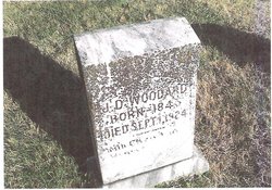
| Description | : | George Washington "Wash" Woodard. Birth: 1805 in Rappahannock County ,VA. Death: 1862 in McDonald Co., Missouri Burial: Roller, Missouri Cemetery Note: 1850 census Rappahannock Co., Va. r#972 Oct.22, line 23-684 Washington Woodard age 45 farmer b.Va. Cely - 49 b.Va. George W. - 19 b.Va. Jordan T. - 16 b.Va. Elizabeth - 12 b.Va. Matilda - 8 b.Va. ... Read More |
frequently asked questions (FAQ):
-
Where is George Washington “Wash” Woodard's memorial?
George Washington “Wash” Woodard's memorial is located at: Ensign Cemetery, Ensign, Gray County, USA.
-
When did George Washington “Wash” Woodard death?
George Washington “Wash” Woodard death on 1862 in McDonald County, Missouri, USA
-
Where are the coordinates of the George Washington “Wash” Woodard's memorial?
Latitude: 37.6274986
Longitude: -100.2339020
Family Members:
Children


Nearby Cemetories:
1. Cave Cemetery
Gray County, USA
Coordinate: 37.5469017, -100.2518997
2. Johnson Cemetery
Ensign, Gray County, USA
Coordinate: 37.7086010, -100.2156130
3. Concord Cemetery
Ford County, USA
Coordinate: 37.5910988, -100.1157990
4. Amish Cemetery
Dodge City, Ford County, USA
Coordinate: 37.6639500, -100.0913300
5. Fairview Cemetery
Montezuma, Gray County, USA
Coordinate: 37.6431007, -100.4147034
6. Morningside Cemetery
Montezuma, Gray County, USA
Coordinate: 37.5762900, -100.4337100
7. McCauley Cemetery
Fowler, Meade County, USA
Coordinate: 37.4609000, -100.2155800
8. First Congregational Church Cemetery
Fowler, Meade County, USA
Coordinate: 37.4606400, -100.2152600
9. German Mission Schlichting Cemetery
Dodge City, Ford County, USA
Coordinate: 37.5030530, -100.0886890
10. Wilburn Cemetery
Fowler, Meade County, USA
Coordinate: 37.4742012, -100.1264038
11. Christ the King Cemetery
Ford County, USA
Coordinate: 37.6493073, -100.0056305
12. Scroggins Mausoleum
Dodge City, Ford County, USA
Coordinate: 37.7403000, -100.0498200
13. North Mennonite Cemetery
Montezuma, Gray County, USA
Coordinate: 37.6204400, -100.4781500
14. Maple Grove Cemetery
Dodge City, Ford County, USA
Coordinate: 37.7612410, -100.0507630
15. Cimarron Cemetery
Cimarron, Gray County, USA
Coordinate: 37.8178200, -100.3411900
16. Boot Hill Cemetery (Defunct)
Dodge City, Ford County, USA
Coordinate: 37.7544800, -100.0222800
17. Evans Cemetery
Gray County, USA
Coordinate: 37.5325012, -100.4777985
18. Homeland Mennonite Cemetery
Gray County, USA
Coordinate: 37.5469790, -100.4868440
19. Cimarron Cemetery Foote Addition
Cimarron, Gray County, USA
Coordinate: 37.8265700, -100.3452900
20. Ridenhour Cemetery
Ford County, USA
Coordinate: 37.8396988, -100.1716995
21. Prairie Grove Cemetery (Defunct)
Dodge City, Ford County, USA
Coordinate: 37.7612600, -100.0129500
22. Fowler Cemetery
Fowler, Meade County, USA
Coordinate: 37.3732986, -100.2018967
23. Kansas Veterans Cemetery at Fort Dodge
Dodge City, Ford County, USA
Coordinate: 37.7315903, -99.9314041
24. Ingalls-Logan Cemetery
Ingalls, Gray County, USA
Coordinate: 37.8417015, -100.4574966