

Gerald Russell “Jerry” Blair
| Birth | : | 22 Sep 1935 Le Roy, Mower County, Minnesota, USA |
| Death | : | 7 Jan 2015 Fort Dodge, Webster County, Iowa, USA |
| Burial | : | Dayton Cemetery, Dayton, Webster County, USA |
| Coordinate | : | 42.2675000, -94.0755000 |
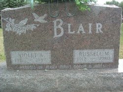
| Description | : | Gerald "Jerry" Bair, 79, of Dayton, Iowa, passed away unexpectedly on Wednesday, January 7, 2015, at Trinity Regional Medical Center in Fort Dodge. Gerald Russell Blair was born on September 22, 1935, in Le Roy, Minnesota, the son of Russell and Violet(Swaney)Blair. He attended country school in Minnesota. The family moved to Dayton Iowa in 1943 to an acreage east of town, and there he finished his schooling. As a young man, Jerry had many jobs, and learned a variety of skills. He especially liked the craftsmanship and quality need to become a cobbler, and had a shoe repair... Read More |
frequently asked questions (FAQ):
-
Where is Gerald Russell “Jerry” Blair's memorial?
Gerald Russell “Jerry” Blair's memorial is located at: Dayton Cemetery, Dayton, Webster County, USA.
-
When did Gerald Russell “Jerry” Blair death?
Gerald Russell “Jerry” Blair death on 7 Jan 2015 in Fort Dodge, Webster County, Iowa, USA
-
Where are the coordinates of the Gerald Russell “Jerry” Blair's memorial?
Latitude: 42.2675000
Longitude: -94.0755000
Family Members:
Parent

Spouse

Siblings

Flowers:


Nearby Cemetories:
1. Dayton Cemetery
Dayton, Webster County, USA
Coordinate: 42.2675000, -94.0755000
2. Christ the King Catholic Cemetery
Dayton, Webster County, USA
Coordinate: 42.2601929, -94.0727539
3. Bass Cemetery
Dayton, Webster County, USA
Coordinate: 42.2966995, -94.0149994
4. Swedish Lutheran Church Cemetery
Dayton, Webster County, USA
Coordinate: 42.2175000, -94.1065000
5. Oak Grove Cemetery
Lehigh, Webster County, USA
Coordinate: 42.3438988, -94.0475006
6. Hardin Township Cemetery
Hardin Township, Webster County, USA
Coordinate: 42.2411003, -93.9708023
7. Linn Cemetery
Pilot Mound, Boone County, USA
Coordinate: 42.2045330, -93.9970230
8. Lawn Cemetery
Boone County, USA
Coordinate: 42.1771011, -94.0867996
9. West Lawn Cemetery
Lehigh, Webster County, USA
Coordinate: 42.3616982, -94.0678024
10. McGuire Bend Cemetery
Dayton, Webster County, USA
Coordinate: 42.3410000, -93.9880000
11. Runyan Cemetery
Pilot Mound, Boone County, USA
Coordinate: 42.1749992, -94.0015030
12. Pilot Mound Cemetery
Pilot Mound, Boone County, USA
Coordinate: 42.1636200, -94.0282600
13. Vegors Cemetery
Webster County, USA
Coordinate: 42.3177986, -93.9421997
14. Lost Grove Cemetery
Harcourt, Webster County, USA
Coordinate: 42.2583008, -94.2331009
15. Hooks Point Cemetery
Hamilton County, USA
Coordinate: 42.2944530, -93.9199090
16. Oakwood Cemetery
Stratford, Hamilton County, USA
Coordinate: 42.2942009, -93.9182968
17. Hartman Cemetery
Lehigh, Webster County, USA
Coordinate: 42.3666397, -93.9835627
18. White Cemetery
Boone County, USA
Coordinate: 42.1777992, -93.9636002
19. Border Plains Cemetery
Border Plains, Webster County, USA
Coordinate: 42.3917000, -94.0448000
20. Ober and Scott Cemetery
Duncombe, Webster County, USA
Coordinate: 42.3841390, -93.9982856
21. Union Cemetery
Boxholm, Boone County, USA
Coordinate: 42.1369019, -94.0852966
22. Renner Cemetery
Boone County, USA
Coordinate: 42.1380420, -94.1256570
23. Otho Cemetery
Otho, Webster County, USA
Coordinate: 42.4025002, -94.1153030
24. Schlicht Cemetery
Fraser, Boone County, USA
Coordinate: 42.1444200, -93.9780100