
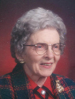
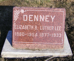
Gertrude Frances “Gertie” Denney Calhoun
| Birth | : | 7 Dec 1905 West Point, Lee County, Iowa, USA |
| Death | : | 15 Sep 2007 Fort Madison, Lee County, Iowa, USA |
| Burial | : | Brooklyn General Cemetery, Brooklyn, Hornsby Shire, Australia |
| Coordinate | : | -33.5471710, 151.1990020 |
| Description | : | The Burlington Hawkeye, Monday, Sept. 17, 2007 Gertrude Calhoun Gertrude "Gertie" Frances Calhoun, 101, of Donnellson and formerly of Burlington, died at 11:05 p.m. Saturday, Sept. 15, 2007, at Fort Madison Community Hospital in Fort Madison. Born Dec. 7, 1905, in rural West Point, she was the daughter of Luther and Elizabeth Herrmann Denney. On Oct. 31, 1929 she married Albert R. "Bert" Calhoun in Fort Madison. He died July 10, 1968. Mrs. Calhoun and her husband operated Ideal Bicycle and Fix-It Shop for 22 years until 1970. She was a member of Zion United Church of Christ, Eagles Aux., Moose Aux., AARP,... Read More |
frequently asked questions (FAQ):
-
Where is Gertrude Frances “Gertie” Denney Calhoun's memorial?
Gertrude Frances “Gertie” Denney Calhoun's memorial is located at: Brooklyn General Cemetery, Brooklyn, Hornsby Shire, Australia.
-
When did Gertrude Frances “Gertie” Denney Calhoun death?
Gertrude Frances “Gertie” Denney Calhoun death on 15 Sep 2007 in Fort Madison, Lee County, Iowa, USA
-
Where are the coordinates of the Gertrude Frances “Gertie” Denney Calhoun's memorial?
Latitude: -33.5471710
Longitude: 151.1990020
Family Members:
Parent

Spouse

Siblings
Flowers:


Nearby Cemetories:
1. Brooklyn General Cemetery
Brooklyn, Hornsby Shire, Australia
Coordinate: -33.5471710, 151.1990020
2. Frances Peat Lone Grave
Mooney Mooney, Central Coast Council, Australia
Coordinate: -33.5333171, 151.1989208
3. Bar Island Cemetery
Hornsby Shire, Australia
Coordinate: -33.5262140, 151.1528610
4. Barrenjoey Head
Palm Beach, Northern Beaches Council, Australia
Coordinate: -33.5802716, 151.3300583
5. Church Point Historic Cemetery
Church Point, Northern Beaches Council, Australia
Coordinate: -33.6450120, 151.2841090
6. Holy Trinity Church Cemetery
Spencer, Central Coast Council, Australia
Coordinate: -33.4293910, 151.1639380
7. Avalon Anglican Columbarium
Avalon, Northern Beaches Council, Australia
Coordinate: -33.6333540, 151.3304900
8. Veteran Hall
Saratoga, Central Coast Council, Australia
Coordinate: -33.4786400, 151.3452750
9. Maloney Gravesite
Glenworth Valley, Central Coast Council, Australia
Coordinate: -33.4039645, 151.1957958
10. Point Clare Cemetery
Point Clare, Central Coast Council, Australia
Coordinate: -33.4344800, 151.3128600
11. Mona Vale Cemetery
Mona Vale, Northern Beaches Council, Australia
Coordinate: -33.6752140, 151.2879720
12. Point Frederick Pioneer Cemetery
Point Frederick, Central Coast Council, Australia
Coordinate: -33.4498830, 151.3417900
13. Mona Vale Anglican Church
Mona Vale, Northern Beaches Council, Australia
Coordinate: -33.6745924, 151.3031547
14. Kincumber South Cemetery
Kincumber South, Central Coast Council, Australia
Coordinate: -33.4880610, 151.3759430
15. Greenway Chapel & Memorial Gardens
Kincumber, Central Coast Council, Australia
Coordinate: -33.4639900, 151.3734500
16. Greengrove Saint Peters Cemetery
Greengrove, Central Coast Council, Australia
Coordinate: -33.3803020, 151.1400300
17. The Old Man's Valley Cemetery
Hornsby, Hornsby Shire, Australia
Coordinate: -33.6994480, 151.0923970
18. Bradys Gully Cemetery
Gosford, Central Coast Council, Australia
Coordinate: -33.4168700, 151.3492720
19. St Paul's Anglican Church Cemetery
Kincumber, Central Coast Council, Australia
Coordinate: -33.4697950, 151.3952220
20. Helys Grave
Wyoming, Central Coast Council, Australia
Coordinate: -33.4031120, 151.3505420
21. Frenchs Forest Cemetery
Davidson, Northern Beaches Council, Australia
Coordinate: -33.7392360, 151.2020750
22. Church of St. Francis and St. Alban
Gordon, Ku-ring-gai Council, Australia
Coordinate: -33.7563700, 151.1522220
23. St. John's Anglican Church Cemetery
Gordon, Ku-ring-gai Council, Australia
Coordinate: -33.7571060, 151.1519580
24. Cherrybrook Uniting Church Cemetery
Cherrybrook, Hornsby Shire, Australia
Coordinate: -33.7304230, 151.0428770