
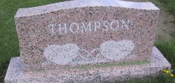
Glenn Harvey Thompson
| Birth | : | 27 Mar 1930 Beaver City Township, Furnas County, Nebraska, USA |
| Death | : | 27 May 2004 Union County, Iowa, USA |
| Burial | : | Ford Cemetery, Ford, Metropolitan Borough of Sefton, England |
| Coordinate | : | 53.4824040, -2.9925980 |
| Plot | : | Section - First, Lot - 174, Space - 1 |
| Description | : | Glenn Harvey Thompson, 74, of Thayer died of complications from Alzheimer's May 27, 2004, at the Afton Care Center. Glenn Thompson, son of Ruby A. (Manley) and Harvey H. Thompson, was born March 27, 1930, in Beaver City, Neb. He attended Talmage and Cromwell schools. On June 5, 1949, he married Norma Carol Lamb in the Evangelical Church at Afton. They settled near Talmage, farming in Talmage and Afton area. In 1959, they moved to Thayer and owned and operated the Hilltop Service Station and Caf & eacute;. They also operated Thompson Trucking service, and he continued working as a... Read More |
frequently asked questions (FAQ):
-
Where is Glenn Harvey Thompson's memorial?
Glenn Harvey Thompson's memorial is located at: Ford Cemetery, Ford, Metropolitan Borough of Sefton, England.
-
When did Glenn Harvey Thompson death?
Glenn Harvey Thompson death on 27 May 2004 in Union County, Iowa, USA
-
Where are the coordinates of the Glenn Harvey Thompson's memorial?
Latitude: 53.4824040
Longitude: -2.9925980
Family Members:
Parent

Siblings

Flowers:


Nearby Cemetories:
1. Ford Cemetery
Ford, Metropolitan Borough of Sefton, England
Coordinate: 53.4824040, -2.9925980
2. Thornton Garden of Rest and Crematorium
Thornton, Metropolitan Borough of Sefton, England
Coordinate: 53.5001850, -2.9951960
3. St Faiths Churchyard
Waterloo, Metropolitan Borough of Sefton, England
Coordinate: 53.4810510, -3.0230370
4. St Peter and St Paul Churchyard
Crosby, Metropolitan Borough of Sefton, England
Coordinate: 53.4858300, -3.0234920
5. St Luke Churchyard
Great Crosby, Metropolitan Borough of Sefton, England
Coordinate: 53.4909310, -3.0240300
6. Bootle Cemetery
Bootle, Metropolitan Borough of Sefton, England
Coordinate: 53.4627680, -2.9787450
7. Aintree Racecourse Grounds
Aintree Village, Metropolitan Borough of Sefton, England
Coordinate: 53.4733880, -2.9549700
8. Harkirk Burial Ground
Little Crosby, Metropolitan Borough of Sefton, England
Coordinate: 53.5016890, -3.0191220
9. Sefton Parish Churchyard
Sefton, Metropolitan Borough of Sefton, England
Coordinate: 53.5044060, -2.9712190
10. Walton Park Cemetery
Walton, Metropolitan Borough of Liverpool, England
Coordinate: 53.4564370, -2.9695960
11. Kirkdale Cemetery
Liverpool, Metropolitan Borough of Liverpool, England
Coordinate: 53.4672530, -2.9479800
12. St. Mary Roman Catholic Churchyard
Little Crosby, Metropolitan Borough of Sefton, England
Coordinate: 53.5076380, -3.0274720
13. St. Mary's Churchyard
Bootle, Metropolitan Borough of Sefton, England
Coordinate: 53.4492620, -3.0006520
14. Rice Lane Jewish Cemetery
Walton, Metropolitan Borough of Liverpool, England
Coordinate: 53.4521700, -2.9590600
15. St Mary the Virgin Churchyard
Walton, Metropolitan Borough of Liverpool, England
Coordinate: 53.4464930, -2.9673330
16. Everton Cemetery
Everton, Metropolitan Borough of Liverpool, England
Coordinate: 53.4555430, -2.9442480
17. Long Lane Jewish Cemetery
Liverpool, Metropolitan Borough of Liverpool, England
Coordinate: 53.4550140, -2.9420480
18. St. Andrew Churchyard
Maghull, Metropolitan Borough of Sefton, England
Coordinate: 53.5104770, -2.9428820
19. St. Alexander Church
Bootle, Metropolitan Borough of Sefton, England
Coordinate: 53.4401090, -2.9922250
20. Ince Blundell Cemetery
Ince Blundell, Metropolitan Borough of Sefton, England
Coordinate: 53.5213570, -3.0208750
21. Melling Churchyard
Melling, Metropolitan Borough of Sefton, England
Coordinate: 53.4953370, -2.9228780
22. St Thomas and the Holy Rood Churchyard
Melling, Metropolitan Borough of Sefton, England
Coordinate: 53.4954510, -2.9227850
23. St Luke Churchyard
Walton, Metropolitan Borough of Liverpool, England
Coordinate: 53.4396910, -2.9671400
24. Kirkdale Goal Cemetery
Kirkdale, Metropolitan Borough of Liverpool, England
Coordinate: 53.4361110, -2.9802780