
| Memorials | : | 1368 |
| Location | : | Everton, Metropolitan Borough of Liverpool, England |
| Coordinate | : | 53.4555430, -2.9442480 |
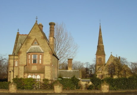
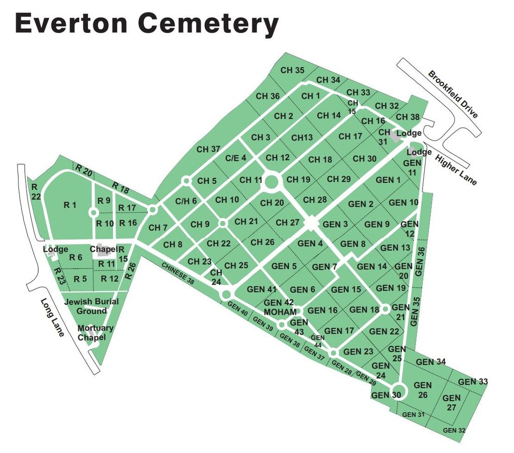
| Description | : | This cemetery is also described (by the Commonwealth War Graves Commission) as Liverpool(Everton) Cemetery. It is in the Fazakerley area, but the address is Everton.Everton and Liverpool are geographically in the County of LANCASHIRE but for administrative purposes, they are now in Merseyside. The cemetery was opened in July 1880 and is used for both Church of England and Roman Catholic burials. Various buildings at the cemetery are Grade II listed buildings. In December 1914, Liverpool became one of the 21 Auxiliary Patrol Bases and in February 1915, the base of the 10th Cruiser Squadron. During the Second World War,... Read More |
frequently asked questions (FAQ):
-
Where is Everton Cemetery?
Everton Cemetery is located at Long Lane Everton, Metropolitan Borough of Liverpool ,Merseyside , L9 9AGEngland.
-
Everton Cemetery cemetery's updated grave count on graveviews.com?
1368 memorials
-
Where are the coordinates of the Everton Cemetery?
Latitude: 53.4555430
Longitude: -2.9442480
Nearby Cemetories:
1. Long Lane Jewish Cemetery
Liverpool, Metropolitan Borough of Liverpool, England
Coordinate: 53.4550140, -2.9420480
2. Rice Lane Jewish Cemetery
Walton, Metropolitan Borough of Liverpool, England
Coordinate: 53.4521700, -2.9590600
3. Kirkdale Cemetery
Liverpool, Metropolitan Borough of Liverpool, England
Coordinate: 53.4672530, -2.9479800
4. Walton Park Cemetery
Walton, Metropolitan Borough of Liverpool, England
Coordinate: 53.4564370, -2.9695960
5. St Mary the Virgin Churchyard
Walton, Metropolitan Borough of Liverpool, England
Coordinate: 53.4464930, -2.9673330
6. West Derby Cemetery
West Derby, Metropolitan Borough of Liverpool, England
Coordinate: 53.4513790, -2.9154630
7. West Derby Jewish Cemetery
Liverpool, Metropolitan Borough of Liverpool, England
Coordinate: 53.4504986, -2.9137393
8. Aintree Racecourse Grounds
Aintree Village, Metropolitan Borough of Sefton, England
Coordinate: 53.4733880, -2.9549700
9. St Luke Churchyard
Walton, Metropolitan Borough of Liverpool, England
Coordinate: 53.4396910, -2.9671400
10. Anfield Cemetery and Crematorium
Anfield, Metropolitan Borough of Liverpool, England
Coordinate: 53.4354680, -2.9578100
11. Bootle Cemetery
Bootle, Metropolitan Borough of Sefton, England
Coordinate: 53.4627680, -2.9787450
12. St Swithins Churchyard
Liverpool, Metropolitan Borough of Liverpool, England
Coordinate: 53.4585631, -2.9012280
13. Kirkdale Goal Cemetery
Kirkdale, Metropolitan Borough of Liverpool, England
Coordinate: 53.4361110, -2.9802780
14. St. Mary's Cemetery
Kirkdale, Metropolitan Borough of Liverpool, England
Coordinate: 53.4323690, -2.9752500
15. St. Alexander Church
Bootle, Metropolitan Borough of Sefton, England
Coordinate: 53.4401090, -2.9922250
16. Green Lane Jewish Cemetery
Liverpool, Metropolitan Borough of Liverpool, England
Coordinate: 53.4234720, -2.9280170
17. St. Mary's Churchyard
Bootle, Metropolitan Borough of Sefton, England
Coordinate: 53.4492620, -3.0006520
18. St. George Churchyard
Everton, Metropolitan Borough of Liverpool, England
Coordinate: 53.4252810, -2.9713940
19. Ford Cemetery
Ford, Metropolitan Borough of Sefton, England
Coordinate: 53.4824040, -2.9925980
20. St. Anthony's Churchyard
Liverpool, Metropolitan Borough of Liverpool, England
Coordinate: 53.4223190, -2.9815350
21. Saint Anne Churchyard
Stanley, Metropolitan Borough of Liverpool, England
Coordinate: 53.4158800, -2.9238300
22. Melling Churchyard
Melling, Metropolitan Borough of Sefton, England
Coordinate: 53.4953370, -2.9228780
23. St. Chad Churchyard
Kirkby, Metropolitan Borough of Knowsley, England
Coordinate: 53.4842890, -2.8930700
24. St Thomas and the Holy Rood Churchyard
Melling, Metropolitan Borough of Sefton, England
Coordinate: 53.4954510, -2.9227850