
| Birth | : | 12 Sep 1930 Wheeling, Ohio County, West Virginia, USA |
| Death | : | 25 Feb 1977 Tuscarawas, Tuscarawas County, Ohio, USA |
| Burial | : | Saint Bridgets Cemetery, Glassboro, Gloucester County, USA |
| Coordinate | : | 39.7023300, -75.1159000 |
| Plot | : | Sec E, Plot #419 |
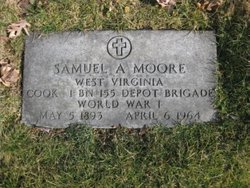
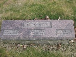
| Description | : | Gloria May Moore was the daughter of Samuel Asbury Moore and Madge Alverta Marshall. She married John Eldon Latimer on March 27, 1948 in Carrollton, Carroll Co., OH. They had four children: June Alberta, Karen Irene, another girl and John Eldon. |
frequently asked questions (FAQ):
-
Where is Gloria May Moore Latimer's memorial?
Gloria May Moore Latimer's memorial is located at: Saint Bridgets Cemetery, Glassboro, Gloucester County, USA.
-
When did Gloria May Moore Latimer death?
Gloria May Moore Latimer death on 25 Feb 1977 in Tuscarawas, Tuscarawas County, Ohio, USA
-
Where are the coordinates of the Gloria May Moore Latimer's memorial?
Latitude: 39.7023300
Longitude: -75.1159000
Family Members:
Parent

Spouse

Siblings
Children
Flowers:


Nearby Cemetories:
1. Saint Bridgets Cemetery
Glassboro, Gloucester County, USA
Coordinate: 39.7023300, -75.1159000
2. Trinity Bible Cemetery
Glassboro, Gloucester County, USA
Coordinate: 39.7003610, -75.1133800
3. Saint Thomas Episcopal Church Cemetery
Glassboro, Gloucester County, USA
Coordinate: 39.7079200, -75.1101500
4. First United Methodist Church Cemetery
Glassboro, Gloucester County, USA
Coordinate: 39.7068900, -75.1081300
5. Manahath Cemetery
Glassboro, Gloucester County, USA
Coordinate: 39.7154236, -75.1141129
6. Land Of Canaan Cemetery
Glassboro, Gloucester County, USA
Coordinate: 39.6741982, -75.1085968
7. Cost Family Cemetery
Pitman, Gloucester County, USA
Coordinate: 39.7307100, -75.1332310
8. Aura Methodist Cemetery
Aura, Gloucester County, USA
Coordinate: 39.6725006, -75.1374969
9. Richwood United Methodist Church Cemetery
Richwood, Gloucester County, USA
Coordinate: 39.7211100, -75.1667700
10. Hillcrest Memorial Park
Hurffville, Gloucester County, USA
Coordinate: 39.7491989, -75.1110992
11. Cedar Green Cemetery
Clayton, Gloucester County, USA
Coordinate: 39.6613998, -75.0852966
12. Bunker Hill Presbyterian Church Cemetery
Gloucester County, USA
Coordinate: 39.7451600, -75.0849200
13. Downer United Methodist Church Cemetery
Williamstown, Gloucester County, USA
Coordinate: 39.6929700, -75.0523200
14. Gloucester County Veterans Memorial Cemetery
Williamstown, Gloucester County, USA
Coordinate: 39.6521279, -75.1163586
15. Bethel Methodist Church Cemetery
Hurffville, Gloucester County, USA
Coordinate: 39.7571983, -75.1110992
16. Hardingville Cemetery
Hardingville, Gloucester County, USA
Coordinate: 39.6632100, -75.1790400
17. Mount Zion Methodist Church Cemetery
Barnsboro, Gloucester County, USA
Coordinate: 39.7547540, -75.1629530
18. Driver Cemetery
Barnsboro, Gloucester County, USA
Coordinate: 39.7631000, -75.1554900
19. Cross Keys Methodist Cemetery
Williamstown, Gloucester County, USA
Coordinate: 39.7124800, -75.0273100
20. Jesse Chew Cemetery
Gloucester County, USA
Coordinate: 39.7736800, -75.1498250
21. Bunker Hill Presbyterian Church Cemetery
Sewell, Gloucester County, USA
Coordinate: 39.7767514, -75.0931293
22. Saint Johns United Methodist Cemetery
Turnersville, Gloucester County, USA
Coordinate: 39.7598300, -75.0487100
23. Chickory Chapel Cemetery
Gloucester County, USA
Coordinate: 39.6244011, -75.1318970
24. Mullica Hill Friends Cemetery
Mullica Hill, Gloucester County, USA
Coordinate: 39.7315712, -75.2244415