
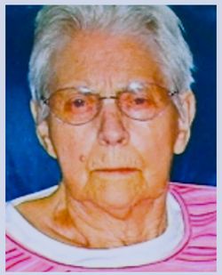

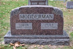
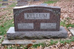
Grace Modderman Kellum
| Birth | : | 26 May 1910 Jefferson Township, Butler County, Iowa, USA |
| Death | : | 9 Jun 2006 Shell Rock, Butler County, Iowa, USA |
| Burial | : | Warwick General Cemetery, Warwick, Southern Downs Region, Australia |
| Coordinate | : | -28.2100890, 152.0044080 |
| Description | : | daughter of Simon & Tena Nieuwbeeta Modderman Grace Kellum, 96, of Waverly, Iowa, died Friday morning, June 9, 2006, at the Shell Rock Health Care Center, Shell Rock, Iowa, of natural causes. Grace was born on May 26, 1910, in Jefferson Township, Butler County, Iowa, the daughter of Simon and Tena (Nieuwbeerta) Modderman. Grace attended country school 3 miles west of Shell Rock. On November 20, 1930, Grace was united in marriage to Sam Kellum in Allison, Iowa, and to this union two sons, Duane and Robert were born. The couple farmed all their married life in... Read More |
frequently asked questions (FAQ):
-
Where is Grace Modderman Kellum's memorial?
Grace Modderman Kellum's memorial is located at: Warwick General Cemetery, Warwick, Southern Downs Region, Australia.
-
When did Grace Modderman Kellum death?
Grace Modderman Kellum death on 9 Jun 2006 in Shell Rock, Butler County, Iowa, USA
-
Where are the coordinates of the Grace Modderman Kellum's memorial?
Latitude: -28.2100890
Longitude: 152.0044080
Family Members:
Parent

Spouse
Siblings
Children
Flowers:


Nearby Cemetories:
1. Warwick General Lawn Cemetery
Warwick, Southern Downs Region, Australia
Coordinate: -28.2106310, 152.0039087
2. Warwick War Cemetery
Warwick, Southern Downs Region, Australia
Coordinate: -28.2089620, 152.0033530
3. Eden Gardens Memorial Park
Warwick, Southern Downs Region, Australia
Coordinate: -28.2229690, 152.0031130
4. St Marks Anglican Church Columbarium Wall
Warwick, Southern Downs Region, Australia
Coordinate: -28.2161000, 152.0347600
5. Lone Grave Warwick
Warwick, Southern Downs Region, Australia
Coordinate: -28.2316590, 151.9833180
6. Warwick-Conway Family Homestead Cemetery
Warwick, Southern Downs Region, Australia
Coordinate: -28.1258400, 152.0395700
7. Swan Creek Anglican Cemetery
Swan Creek, Southern Downs Region, Australia
Coordinate: -28.1974400, 152.1364830
8. Glengallan Station
Warwick, Southern Downs Region, Australia
Coordinate: -28.1027016, 152.0585067
9. Yangan Presbyterian Church Cemetery
Yangan, Southern Downs Region, Australia
Coordinate: -28.1972310, 152.2142130
10. Yangan General and Anglican Cemetery
Emu Vale, Southern Downs Region, Australia
Coordinate: -28.2059990, 152.2207110
11. Allora Cemetery
Allora, Southern Downs Region, Australia
Coordinate: -28.0199230, 151.9750720
12. Pratten Cemetery
Pratten, Southern Downs Region, Australia
Coordinate: -28.0858450, 151.7790540
13. Dalveen-Mitchell Family Homestead Cemetery
Dalveen, Southern Downs Region, Australia
Coordinate: -28.4423200, 151.9604000
14. Maryvale Homestead Cemetery
Warwick, Southern Downs Region, Australia
Coordinate: -28.0669430, 152.2405230
15. Maryvale Cemetery
Maryvale, Southern Downs Region, Australia
Coordinate: -28.0607800, 152.2474610
16. Killarney Lawn Cemetery
Killarney, Southern Downs Region, Australia
Coordinate: -28.3475760, 152.2742790
17. Strath Elbess Cemetery
Dalveen, Southern Downs Region, Australia
Coordinate: -28.4883070, 151.9692850
18. Clifton General Cemetery
Clifton, Toowoomba Region, Australia
Coordinate: -27.9389150, 151.9120790
19. Headington Hill Lutheran Cemetery
Allora, Southern Downs Region, Australia
Coordinate: -27.9037210, 152.0020290
20. Back Plains Cemetery
Back Plains, Toowoomba Region, Australia
Coordinate: -27.9121770, 151.7970240
21. Spicers Gap
Boonah, Scenic Rim Region, Australia
Coordinate: -28.0733318, 152.4255524
22. Nobby Cemetery
Nobby, Toowoomba Region, Australia
Coordinate: -27.8322200, 151.8662000
23. Leyburn Cemetery
Leyburn, Southern Downs Region, Australia
Coordinate: -28.0085654, 151.5913366
24. Lone Grave Leyburn
Leyburn, Southern Downs Region, Australia
Coordinate: -28.0189540, 151.5842910