
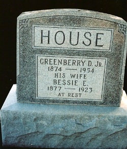
Greenberry Dillard House Jr.
| Birth | : | 27 Nov 1874 |
| Death | : | 1954 |
| Burial | : | Walpole St Andrew, Walpole, Kings Lynn and West Norfolk Borough, England |
| Coordinate | : | 52.7349520, 0.2227630 |
| Plot | : | Section 3, Row 5.5, Grouping 6 |
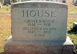
| Description | : | Greenberry Dillard House, leading farmer of Burkittsvilla District, Frederick County, MD., son of Grove and Melissa (Dillard) House, was born on the place which he now owns, November 27, 1875. The parents of Mr. House are both living. His grandfather, Greenberry House, who married Mary Grove, is one of the oldest and best known citizens of Frederick County. When Greenberry D. House was eight years old, he became a pupil in the public school near his home, and continued to attend his winter terms until he reached the age of nineteen. He then spent two terms under Professor Shank, at... Read More |
frequently asked questions (FAQ):
-
Where is Greenberry Dillard House Jr.'s memorial?
Greenberry Dillard House Jr.'s memorial is located at: Walpole St Andrew, Walpole, Kings Lynn and West Norfolk Borough, England.
-
When did Greenberry Dillard House Jr. death?
Greenberry Dillard House Jr. death on 1954 in
-
Where are the coordinates of the Greenberry Dillard House Jr.'s memorial?
Latitude: 52.7349520
Longitude: 0.2227630
Family Members:
Parent

Spouse

Children

Flowers:


Nearby Cemetories:
1. Walpole St Andrew
Walpole, Kings Lynn and West Norfolk Borough, England
Coordinate: 52.7349520, 0.2227630
2. Walpole St Andrew - Extension
Walpole, Kings Lynn and West Norfolk Borough, England
Coordinate: 52.7314600, 0.2162800
3. St. Peter's Churchyard
Walpole, Kings Lynn and West Norfolk Borough, England
Coordinate: 52.7284200, 0.2219100
4. St. John's Churchyard
Terrington St John, Kings Lynn and West Norfolk Borough, England
Coordinate: 52.7183750, 0.2778270
5. St. Matthew's Churchyard
Sutton Bridge, South Holland District, England
Coordinate: 52.7682100, 0.1903100
6. Terrington Saint Clement Methodist Cemetery
Terrington St Clement, Kings Lynn and West Norfolk Borough, England
Coordinate: 52.7589440, 0.2899360
7. Tilney St. Lawrence Churchyard
Tilney St Lawrence, Kings Lynn and West Norfolk Borough, England
Coordinate: 52.7089510, 0.2923460
8. St. Mary Churchyard
Tydd St Mary, South Holland District, England
Coordinate: 52.7456600, 0.1404600
9. St Clement Churchyard
Terrington St Clement, Kings Lynn and West Norfolk Borough, England
Coordinate: 52.7593100, 0.2975600
10. Tilney All Saints Churchyard
Tilney All Saints, Kings Lynn and West Norfolk Borough, England
Coordinate: 52.7366790, 0.3214680
11. St Mary's Church Islington
Tilney All Saints, Kings Lynn and West Norfolk Borough, England
Coordinate: 52.7268530, 0.3246890
12. All Saints Churchyard
Walsoken, Kings Lynn and West Norfolk Borough, England
Coordinate: 52.6721700, 0.1816130
13. St. Giles' Churchyard
Tydd St Giles, Fenland District, England
Coordinate: 52.7269470, 0.1118120
14. Mount Pleasant Cemetery
Wisbech, Fenland District, England
Coordinate: 52.6719840, 0.1644770
15. Marshland St. James Cemetery
Marshland St James, Kings Lynn and West Norfolk Borough, England
Coordinate: 52.6604540, 0.2465520
16. St Augustine Churchyard
Wisbech, Fenland District, England
Coordinate: 52.6679000, 0.1633300
17. Long Sutton Cemetery
Long Sutton, South Holland District, England
Coordinate: 52.7848300, 0.1272300
18. St. Mary's Churchyard
Long Sutton, South Holland District, England
Coordinate: 52.7844700, 0.1221800
19. Long Sutton Baptist Churchyard
Long Sutton, South Holland District, England
Coordinate: 52.7837460, 0.1204960
20. St Peter & St Paul Churchyard
Wisbech, Fenland District, England
Coordinate: 52.6639880, 0.1626020
21. St Margaret's Churchyard
Clenchwarton, Kings Lynn and West Norfolk Borough, England
Coordinate: 52.7569690, 0.3548660
22. Gorefield Congregational Churchyard
Gorefield, Fenland District, England
Coordinate: 52.6865500, 0.0968700
23. St Paul Churchyard
Gorefield, Fenland District, England
Coordinate: 52.6873400, 0.0944700
24. St. Edmund Churchyard
Emneth, Kings Lynn and West Norfolk Borough, England
Coordinate: 52.6438200, 0.1989100